History / Search
38123 passages in 1427 source items for “The Island of Broken Bricks”
Collection
All
🏹 Indigenous Peoples & Archaeology
📜 Colonial & Dutch Records
📖 Westchester County Histories
🏘️ Croton Local History
🏛️ Government Documents
No passages matched all of those words — showing passages that match any of them, best matches first.
brickcollecting.com
…1700 -- death of Stephanus Van Cortlandt. Son Philip Van Cortlandt became Second Lord of the Manor. His wife was Catherine de Peyster. After the father's death, the 83,000 acre estate was gradually broken up.
Show 8 of 132 matching passages
Croton on Hudson Bricks §102
— …1700 -- death of Stephanus Van Cortlandt. Son Philip Van Cortlandt became Second Lord of the Manor. His wife was Catherine de Peyster. After the father's death, the 83,000 acre estate was gradually broken up.
Croton on Hudson Bricks §86
— Cruger's to York Island, may be seen from this hill. Before it lies Haverstraw Bay, the widest expanse of the Hudson, with all its historic and legendary associations, which limited space forbids us to portray. Here the fresh and…
Croton on Hudson Bricks §39
— Talcott, a machinist and later his son-in-law and Richard Walker who assumed responsibility for the transportation of the bricks. (Ed Note: Scroll down for more information on Richard Talcott.) Advertising for the bricks stressed "their fine edge and
Croton on Hudson Bricks §63
— extraordinarily successful businessman. After lower Manhattan was destroyed by a fire, there was high demand for brick to rebuild. Robert Underhill seized the opportunity by manufacturing bricks in a new firm, Underhill Talcott Brick Co. Robert had
Croton on Hudson Bricks §131
— SHOP Visitors' Comments/Collections/Brix Pix | Our Collection HOME
Croton on Hudson Bricks §130
— https://www.davidrumsey.com https://quod.lib.umich.edu https://www.threerivershms.com/hudsonch17.htm https://cdl.library.cornell.edu/moa/moa_search.html Hudson River Brickmaking | Brick History/How Bricks Were Made Links | Contact Form | IBCA | BOOK
Croton on Hudson Bricks §0
— TALES FROM CROTON POINT:A BRIEF HISTORY of CROTON-ON-HUDSON Hudson River Brickmaking | Brick History/How Bricks Were Made Links | Brick BLog | IBCA | THE OLD BRICK STORE Visitors' Comments/Collections/Brix Pix | Our Collection/Brick Finder Site Index
Croton on Hudson Bricks §109
— bricks on his 165 acres. Richard built a mansion called Interwasser near the southern tip of Croton Point. 1835 New York City voted to construct a 40 mile brick-lined gravity-fed aqueduct from the Croton River into Manhattan. 1837…
Tower, Fayette B. Illustrations of the Croton Aqueduct. New York: Wiley and Putnam, 1843.
…of
hardness that they present a cherry red, or brownish color,
and give a clear ringing sound when struck ; and when
broken, must present a compact and uniform texture. All
bricks brought upon the work which are soft and of…
Show 8 of 237 matching passages
Illustrations of the Croton Aqueduct §104
— …of
hardness that they present a cherry red, or brownish color,
and give a clear ringing sound when struck ; and when
broken, must present a compact and uniform texture. All
bricks brought upon the work which are soft and of…
Illustrations of the Croton Aqueduct §105
— …of
hardness that they present a cherry red, or brownish color,
and give a clear ringing sound when struck ; and when
broken, must present a compact and uniform texture. All
bricks brought upon the work which are soft and of…
Illustrations of the Croton Aqueduct §152
— …the rock, which over the whole island, presents a singularly
broken and uneven formation. In almost every instance of
excavation, the rock was found above the proposed bottom
of the Reservoir, and the difficulty of preventing leakage
along the surface…
Illustrations of the Croton Aqueduct §197
— …that bricks harden the softest water, and give it an aluminous impregnation. The old wells must, therefore, furnish much purer water than the more
recent, as the soluble particles are gradually washed away. It contains a greater
proportion of earthy…
Illustrations of the Croton Aqueduct §198
— …that bricks harden the softest water, and give it an aluminous impregnation. The old wells must, therefore, furnish much purer water than the more
recent, as the soluble particles are gradually washed away. It contains a greater
proportion of earthy…
Illustrations of the Croton Aqueduct §153
— the rock, which over the whole island, presents a singularly
broken and uneven formation. In almost every instance of
excavation, the rock was found above the proposed bottom
of the Reservoir, and the difficulty of preventing leakage
along the surface…
Illustrations of the Croton Aqueduct §101
— …In forming the concrete a mortar is made by mixing three
parts of sand with one of hydraulic lime, and then mixing
about three parts of stone, broken to a size allowing them to
pass through a ring an inch…
Illustrations of the Croton Aqueduct §24
— …No bricks were used in the construction of the channelway of the Aqueduct.
Ventilators were constructed along the course of the
Aqueduct 2 feet square, and rising above the ground 2 or 3
feet. The Aqueduct when it was above…
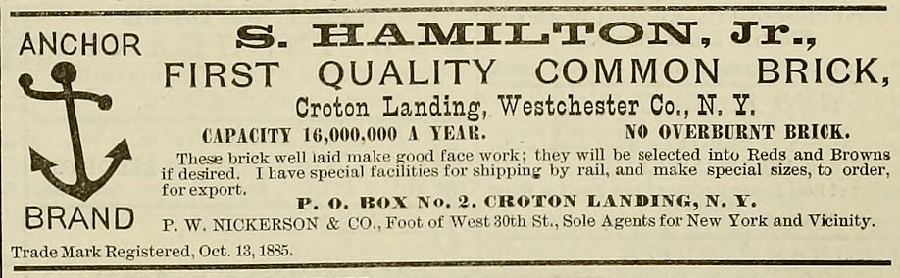
crotonhistory.org — https://crotonhistory.org/2012/03/17/anchor-brand-bricks-at-croton-landing-1889/
Anchor Brand Bricks at Croton Landing, 1889
[Article content from crotonhistory.org - see URL for full text and images]
Date: Various
Source: crotonhistory.org — https://crotonhistory.org/2012/03/17/anchor-brand-bricks-at-croton-landing-1889/
License: Used with…
crotonhistory.org
17, 2013
Show 3 matching passages
Anchor Brand Bricks At Croton Landing 1889 §1
— (Opens in new window) X Share on Pinterest (Opens in new window) Pinterest Share on Tumblr (Opens in new window) Tumblr Share on LinkedIn (Opens in new window) LinkedIn Like Loading... Related Tagged Croton Landing Published March 17, 2012 February
Anchor Brand Bricks At Croton Landing 1889 §0
— “No Overburnt Brick” An ad from the Real Estate Record and Builders’ Guide , July 6, 1889. Share this: Print (Opens in new window) Print Email a link to a friend (Opens in new window) Email Share on Facebook (Opens in…
crotonhistory.org
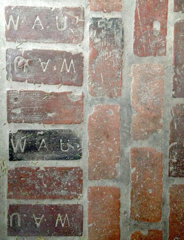
…Underhill, who used the clay deposits to make bricks on the north end of Croton Point while his brother, Richard T. Underhill developed his famous vineyards on the southern end. The house also features other Underhill bricks, stamped with
Show 3 matching passages
History Underfoot §1
— …Underhill, who used the clay deposits to make bricks on the north end of Croton Point while his brother, Richard T. Underhill developed his famous vineyards on the southern end. The house also features other Underhill bricks, stamped with
History Underfoot §0
— While visiting a home in the Harmon area the owners proudly pointed out the Croton Point bricks used in the floor of what had originally been a large covered porch. Well-worn from more than a century of use, many…
History Underfoot §2
— the letters IXL (a clever bit of self-promotion meaning “I excel . . . at brickmaking”), and stonework by masons who worked on the New Croton Dam. For additional information about the Underhill brickyard, see this article written by Robert
crotonhistory.org
If you’re walking on Elliott Way, south of the Yacht Club, you’ll see some red bricks scattered among the rip rap along the shore. These all appear to be what were called Croton Point bricks, made at the…
Show 6 matching passages
History On The River §0
— If you’re walking on Elliott Way, south of the Yacht Club, you’ll see some red bricks scattered among the rip rap along the shore. These all appear to be what were called Croton Point bricks, made at the…
History On The River §1
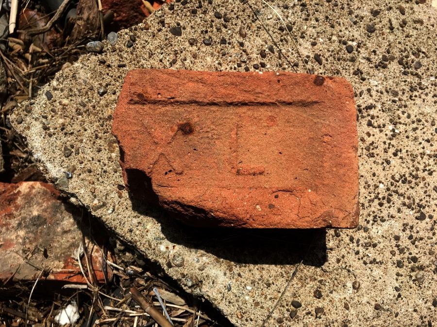
— end of the point. Some Underhill bricks were stamped with his initials (WAU) but others, like the partial example shown above, were stamped IXL, a clever bit of self-promotion meaning “ I excel ” at brickmaking. During the height of the…
History On The River §2
— …brickyards on the shores of Haverstraw Bay and in Croton there were five in the area between what is now Half Moon Bay and the end of Croton Landing Park. 1 For some nice examples of WAU bricks see this
History On The River §5
— A. Underhill Published April 9, 2017 April 9, 2017
History On The River §3
— post, History Underfoot . United States Coast Survey. Hudson River No. VI, Topographical Survey by F.H. Gerdes. August, 1854. ↩︎ Share this: Print (Opens in new window) Print Email a link to a friend (Opens in new window) Email Share on…
History On The River §4
— (Opens in new window) Facebook Share on X (Opens in new window) X Share on Pinterest (Opens in new window) Pinterest Share on Tumblr (Opens in new window) Tumblr Share on LinkedIn (Opens in new window) LinkedIn Like Loading... Related…
crotonhistory.org
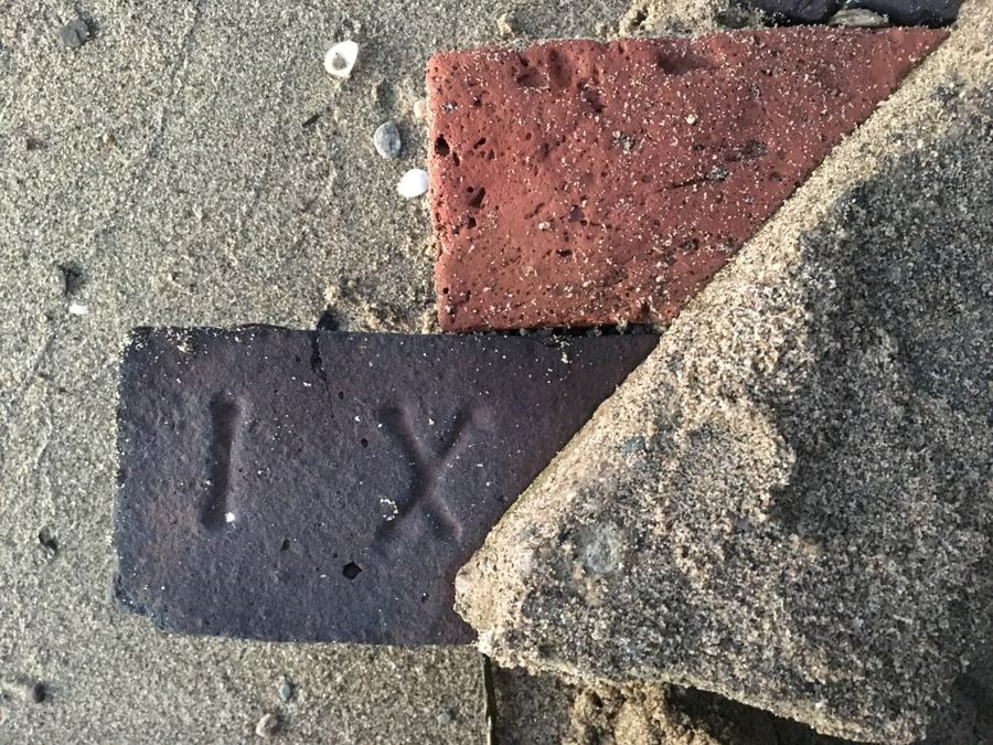
During a walk along the beach on the north side of Croton Point we spotted some old bricks, encased in a piece of concrete. “IX” could be seen stamped on one of them and “XL” on the other. As we…
Show 8 of 10 matching passages
History On The Beach §0
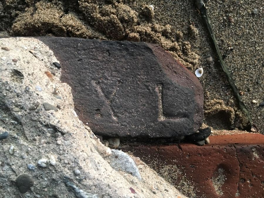
— During a walk along the beach on the north side of Croton Point we spotted some old bricks, encased in a piece of concrete. “IX” could be seen stamped on one of them and “XL” on the other. As we…
History On The Beach §4
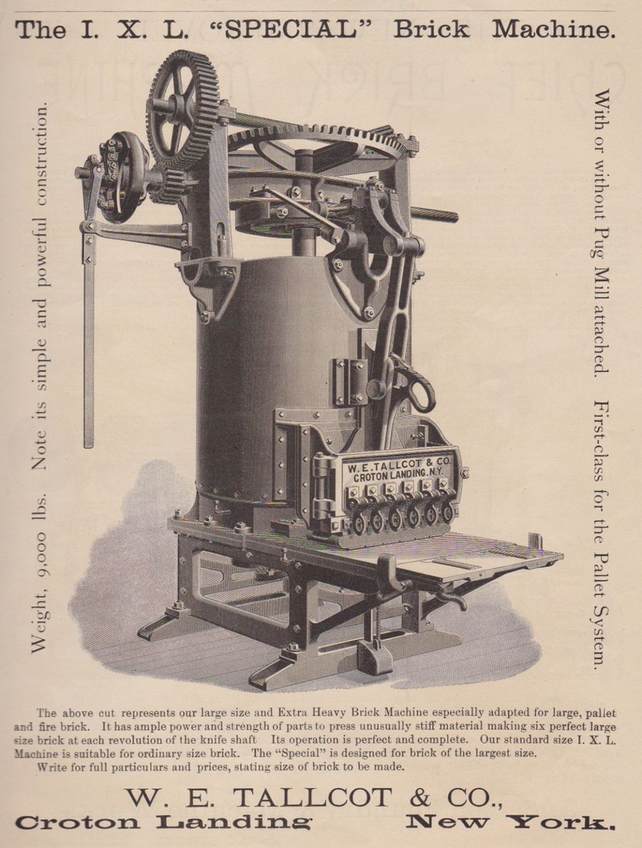
— bricks. The manufacturer of this machine was William Edward Tallcot, who was born in 1852. William’s father, Richard D. Tallcott, owned a brick manufacturing company at Croton Landing and the family was related by marriage to the Underhills. Map…
History On The Beach §1
— …Underhill Brickyard on the northern end of the point, close to where we found them. Some bricks were stamped with Underhill’s initials (WAU) but others, like these, were stamped with the letters IXL—a clever bit of self-promotion
History On The Beach §2
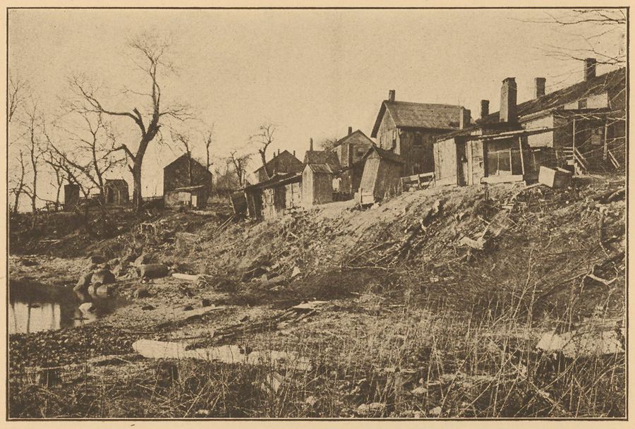
— …Since both bricks look burned, we suspect they were among the rejects that once littered the area. Perhaps they were later picked up and used in the foundation of one of the cabins that were built along the north
History On The Beach §7
— up the fields and pressing the soil into bricks, until it looks as though the place had stood a siege, and the enemy had exploded mines all round its borders.” Read more here . Share this: Print (Opens in new window…
History On The Beach §5
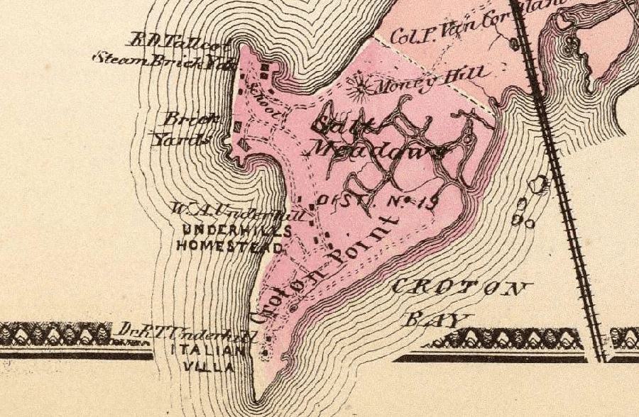
— Croton Point in 1868 from the “ Atlas of New York and vicinity from actual surveys by and under the direction of F.W. Beers ,” showing the R. D. Tallcot Steam Brickyards on the northern tip. We can walk along the…
History On The Beach §3
— shore in the early 20th century. Some of the cabins and outhouses on Croton Point when Westchester County purchased the land. Here’s a 19th century advertisement from The Clay-Worker for the “I. X. L. ‘SPECIAL’ Brick Machine” that…
History On The Beach §6
— when we find bits of Croton’s history, but what we see is only what’s been left after massive changes to the landscape. A visitor in 1890 described Croton as a “quiet hamlet, whose inhabitants have been for several…
O'Callaghan, E.B., ed. The Documentary History of the State of New York, Vol. III. Albany: Weed, Parsons and Co., 1850.
…I am told by the people here, that
pieces of broken bricks are found in all the lands they plough.
Sept. 1** -- I have this day rode a mile and a half into the
woods to examine the remains of…
Show 8 of 2255 matching passages
Documentary History of the State of New York, Vol. III §2077
— …I am told by the people here, that
pieces of broken bricks are found in all the lands they plough.
Sept. 1** -- I have this day rode a mile and a half into the
woods to examine the remains of…
Documentary History of the State of New York, Vol. III §38
— …Nevertheless we contrived to get to the borders of
the lake of the Entouhonorons and at the place where we had
concealed oiu- canoes which we found safe ; for we feared lest
the enemy might have broken them.
Vol. III…
Documentary History of the State of New York, Vol. III §945
— …525
fountain of jusUce was once more cleansed l>y the removal oT Piiinorh, Ihe cor
rupl chief justice, &c." "On i wo Dccjisi.ns tlie Ihimes uf civ il ili-broken out afresh; one…
Documentary History of the State of New York, Vol. III §120
— …Lysbet de Roode, from Dantzick, Wife of John Saline, and child. Sara Teunis.
Ditto ; In the Broken Heart. Lysbeth Jansen van Wie, near Goch. The Wife of Govert van Oy, and two children. Jan Jansen, from Amsterdam.
Claes Gerritsen, son…
Documentary History of the State of New York, Vol. III §2037
— …Gave to
the people 2 addresses,
Tuesday 14th. -- Preached to an audience of 60 persons of
almost all denominations, and appointed a lecture to the N. E.
3^ to-morrow. This town is in a broken state -- about halfif are…
Documentary History of the State of New York, Vol. III §1878
— …And in the year 1756, being
persuaded by General Shirley to accompany him in his way to
Oswego, as an interpreter, which he undertook with a broken
state of health, he sickened and died ; and was buried at
Skenectady.
Martin…
Documentary History of the State of New York, Vol. III §184
— But as many Swedes and Finns to the number at least of vOO
were dwelling two or three miles up the river above Fort
Clirlsrina, the Swedish governor insisted in the Capitulation t? -.at
one Lut'ieran minister should be…
Documentary History of the State of New York, Vol. III §2158
— …The
boiler is even supphed with a safety valve, though part of it has
been broken off."
crotonhistory.org — https://crotonhistory.org/2013/12/08/history-underfoot/
History Underfoot
History Underfoot
A homeowner in Harmon showcased Croton Point bricks integrated into their porch flooring, many bearing the stamp "WAU" (William A. Underhill's initials). These well-preserved bricks, worn by over a century of use, represent the…
Ruttenber, E.M. Footprints of the Red Men: Indian Geographical Names in the Valley of Hudson's River, the Valley of the Mohawk, and on the Delaware. Published in the Proceedings of the New York State Historical Association, Vol. VI. 1906.
…A record description
reads: "There is much broken land here."
Manette, so written of record -- "near Mannato hill," about
thirty miles from Brooklyn and midway between the north and
south sides of the island -- has been interpreted from its equivalent…
Show 8 of 781 matching passages
Footprints of the Red Men: Indian Geographical Names §489
— …A record description
reads: "There is much broken land here."
Manette, so written of record -- "near Mannato hill," about
thirty miles from Brooklyn and midway between the north and
south sides of the island -- has been interpreted from its equivalent…
Footprints of the Red Men: Indian Geographical Names §455
— …them, " Sachem
of Pammananuck,"
to the island. proves nothing in regard to the application of that name
74 INDIAN GEOGRAPHICAL NAMES.
the entrance of this bay are situated several islands, or broken land,
on which a nation of savages have…
Footprints of the Red Men: Indian Geographical Names §350
— …The " island or hummock " came to be the site of the
noted Macomb mansion. The name has not been satisfactorily translated. Mr. Riker
wrote, "Where the stream closes," or is broken off, recognizing
the locative of the name. Ziesberger wrote…
Footprints of the Red Men: Indian Geographical Names §676
— At the foot of the fall the current is divided
by a small island which is said to bear on its flat rock surface a petrifaction having the appearance of a big snake, which may have been
regarded by the…
Footprints of the Red Men: Indian Geographical Names §267
— …Among the supplies was a large number of boxes of chocolate
which had been broken open and their contents strewed upon the
ground, which dissolving in the fervid heat of the summer sun,
mingled with the pools and rivulets of…
Footprints of the Red Men: Indian Geographical Names §319
— …the dominion
of the laws of vegetation, spread out in one vast, continuous interminable forest," broken here and there by the opened patches of cornlands and the wigwams and villages of the redmen ; secondly, to
ascertain the meanings of the…
Footprints of the Red Men: Indian Geographical Names §342
— Meitates means
'■' Small island " as a whole ; Monach'nong means a " Place on the
island," or less than the whole, as shown by the claims of the Indians in 1670, that they had not previously sold all the island. (Col…
Footprints of the Red Men: Indian Geographical Names §506
— Manah=ackaquasu=U'anock, given as the name of Shelter
Island, is a composition of two names, as shown by the record entry, "All that their i.^Iand of Aliaquacu-'wainuck, otherwise called
Manhansack." Ahaqua.zn-zvamnck is no doubt…
crotonhistory.org — https://crotonhistory.org/2017/10/04/history-on-the-beach/
History on the Beach
During a beach walk along Croton Point's north shore, the author discovered old bricks embedded in concrete, stamped with "IX" and "XL" markings. These artifacts originated from William A. Underhill's brickyard at the point…
King, Charles. A Memoir of the Construction, Cost, and Capacity of the Croton Aqueduct. New York: Charles King, 1843.
This kind of masonry was bound, at every four feet of its height, by
two courses of "great bricks," each brick being 22 inches square, and two inches thick. The angles of the piers, formed of small square slabs of…
Show 8 of 765 matching passages
A Memoir of the Construction, Cost, and Capacity of the Croton Aqueduct §106
— This kind of masonry was bound, at every four feet of its height, by
two courses of "great bricks," each brick being 22 inches square, and two inches thick. The angles of the piers, formed of small square slabs of…
A Memoir of the Construction, Cost, and Capacity of the Croton Aqueduct §94
— …When this square was set, the
sides of the caisson were taken off, and another layer of bricks was then laid, and so
Another caisson, and so on. The bricks used in this construction were one foot nine inches
PRELIMINARY…
A Memoir of the Construction, Cost, and Capacity of the Croton Aqueduct §93
— …When this square was set, the
sides of the caisson were taken off, and another layer of bricks was then laid, and so
Another caisson, and so on. The bricks used in this construction were one foot nine inches
A Memoir of the Construction, Cost, and Capacity of the Croton Aqueduct §566
— …This precaution
has had a very salutary influence on the character of the work the cement in all cases
;
where it is exposed to view, in its exterior, or broken up for examination, or otherwise,
has appeared highly satisfactory. In…
A Memoir of the Construction, Cost, and Capacity of the Croton Aqueduct §565
— …A course
of plastering was also put over the roofing arch. The concrete masonry was formed by
mixing one part hydraulic cement, three parts clean sand, and three parts fine broken
stone ;
in some cases fine pebbles were in part…
A Memoir of the Construction, Cost, and Capacity of the Croton Aqueduct §89
— The inside facing of the walls, and the bottom hollowed in the form of an arc of a circle,
were covered with a coat of cement about two inches in thickness, composed of quicklime,
fine sand, and pulverised bricks. This…
A Memoir of the Construction, Cost, and Capacity of the Croton Aqueduct §88
— …The inside facing of the walls, and the bottom hollowed in the form of an arc of a circle,
were covered with a coat of cement about two inches in thickness, composed of quicklime,
fine sand, and pulverised bricks. This…
A Memoir of the Construction, Cost, and Capacity of the Croton Aqueduct §103
— …In the aqueducts not built in the earth, the walls are from 22 to 24 inches thick,
the exterior faces formed of reticulated work, the lozenges being from 3 to 6 inches
square, without any course of bricks. The arch…
crotonhistory.org — https://crotonhistory.org/2017/10/04/history-on-the-beach/
History on the Beach
During a beach walk along Croton Point's north shore, the author discovered old bricks embedded in concrete, stamped with "IX" and "XL" markings. These artifacts originated from William A. Underhill's brickyard at the point…
crotonhistory.org — https://crotonhistory.org/2017/04/09/history-on-the-river/
History on the River
Along Elliott Way near the Yacht Club, red bricks scatter among the shoreline rocks—remnants of the William A. Underhill Brickyard that operated on Croton Point's northern end. These "Croton Point bricks" carried maker's…
crotonhistory.org — https://crotonhistory.org/2017/04/09/history-on-the-river/
History on the River
Along Elliott Way near the Yacht Club, red bricks scatter among the shoreline rocks—remnants of the William A. Underhill Brickyard that operated on Croton Point's northern end. These "Croton Point bricks" carried maker's…
crotonhistory.org — https://crotonhistory.org/2017/10/04/history-on-the-beach/
History on the Beach
During a beach walk along Croton Point's north shore, the author discovered old bricks embedded in concrete, stamped with "IX" and "XL" markings. These artifacts originated from William A. Underhill's brickyard at the point…
crotonhistory.org — https://crotonhistory.org/2017/10/04/history-on-the-beach/
History on the Beach
During a beach walk along Croton Point's north shore, the author discovered old bricks embedded in concrete, stamped with "IX" and "XL" markings. These artifacts originated from William A. Underhill's brickyard at the point…
crotonhistory.org — https://crotonhistory.org/2017/10/04/history-on-the-beach/
History on the Beach
During a beach walk along Croton Point's north shore, the author discovered old bricks embedded in concrete, stamped with "IX" and "XL" markings. These artifacts originated from William A. Underhill's brickyard at the point…
Shonnard, Frederic, and W.W. Spooner. History of Westchester County, New York, from its Earliest Settlement to the Year 1900. New York: The New York History Company, 1900.
…objects on the manor.
one of the prominent
was
The portion of the chimney taken down
relaid with the bricks, Ave feet breast, sixteen
inches deep, to the same height as before, and
a new partition built, fifteen feet long…
Show 8 of 1308 matching passages
History of Westchester County, New York, from its Earliest Settlement to the Year 1900 §327
— …objects on the manor.
one of the prominent
was
The portion of the chimney taken down
relaid with the bricks, Ave feet breast, sixteen
inches deep, to the same height as before, and
a new partition built, fifteen feet long…
History of Westchester County, New York, from its Earliest Settlement to the Year 1900 §95
— Nyack signifies " a point of land," and is the equivalent of the Long Island
Nyack ("Kings County) Noyac (Suffolk County). Kiwigtignock. -- Var., Keioightegnack, He-weghtiquack. An elbow of the Croton River. Whquae-tigu-ack, " land at head of the cove…
History of Westchester County, New York, from its Earliest Settlement to the Year 1900 §328
— The remainder of the bricks
that came out of the chimney-tor. strange to
say, there was a remainder, and a large one.
and with them he
Minnerly bought
too-Mr.
tilled in a new house, twenty-two feet front…
History of Westchester County, New York, from its Earliest Settlement to the Year 1900 §94
— …Nyack signifies " a point of land," and is the equivalent of the Long Island
Nyack ("Kings County) Noyac (Suffolk County). Kiwigtignock. -- Var., Keioightegnack, He-weghtiquack. An elbow of the Croton River. Whquae-tigu-ack, " land at head of the cove…
History of Westchester County, New York, from its Earliest Settlement to the Year 1900 §599
— …in the situation of those who were obliged to make bricks without
straw."
Early on the morning of the 11th of April the rival forces began
to gather at White Plains. The supporters of the announced business of the day…
History of Westchester County, New York, from its Earliest Settlement to the Year 1900 §325
— …of Mount
the Town
John A. Todd,
1(52
HISTORY
WESTCHESTER
COUNTY
view of Dr. Cole's, Tarrytown and the country round about belongto the oldest settled localities of the county. Of course the fact of the
presence of a…
History of Westchester County, New York, from its Earliest Settlement to the Year 1900 §1200
— The Westchester County delegates to the
ih,
m
w Od
Democratic Stale convention were Thomas
larve\
Torter,
the
ml
Jo]
of
Smith, Gilherl S. Lyon, and Abraham Hyatt.
,', fro
-embly
Iw;
m .it li
in esti
J.
v distil.
and…
History of Westchester County, New York, from its Earliest Settlement to the Year 1900 §326
— …very substantially built, " the bricks, and indeed all the building materials," says
was then esMrs.' Lamb, " being imported from Holland at what
teemed aprodigal expenditure. The great massive door, which still
swings in the center of the southern front, was…
illustrations_aqueduct_raw.txt
…of hardness that they present a cherry red, or brownish color, and give a clear ringing sound when struck ; and when broken, must present a compact and uniform texture. All bricks brought upon the work which are soft and of…
Show 8 of 66 matching passages
illustrations_aqueduct_raw §28
— …of hardness that they present a cherry red, or brownish color, and give a clear ringing sound when struck ; and when broken, must present a compact and uniform texture. All bricks brought upon the work which are soft and of…
illustrations_aqueduct_raw §27
— …The surface of the Fountain Reservoir is 166| feet above the level of mean tide at the city of New-York ; and the difference of level between that and the surface of the Re- ceiving Reservoir on the island of…
illustrations_aqueduct_raw §55
— …bricks harden the softest water, and give it an aluminous im- pregnation. The old wells must, therefore, furnish much purer water than the more recent, as the soluble particles are gradually washed away. It contains a greater proportion of earthy…
illustrations_aqueduct_raw §42
— …the rock, which over the whole island, presents a singularly broken and uneven formation. In almost every instance of excavation, the rock was found above the proposed bottom of the Reservoir, and the difficulty of preventing leakage along the surface…
illustrations_aqueduct_raw §6
— …No bricks were used in the construction of the channel- way of the Aqueduct. Ventilators were constructed along the course of the Aqueduct 2 feet square, and rising above the ground 2 or 3 feet. The Aqueduct when it was…
illustrations_aqueduct_raw §14
— …at the same height and level with the head of the springs." " The cisterns or conservatories which they made for these waters, at the top of the mountain, were about 12 feet deep ; the passage was broken through the rocks…
illustrations_aqueduct_raw §24
— …The distance being about forty miles, over a country extremely broken and uneven, and following a direction, for a portion of this distance, parallel with the Hudson River, encountering the streams which 73 empty into it and form deep valleys…
illustrations_aqueduct_raw §5
— …The whole length of this bridge is about 900 feet. The bridge of Gard having been broken down at the two extremities, at a period very remote and uncertain, it is thought that this destruction may be attributed to the…
Macdonald, John. Interview with Mandeville, James, 1760-1848; (1845-09-23). Experiencing the Neutral Ground of the American Revolution: The McDonald Interviews, WCHS item 1226. Transcription courtesy of the Westchester County Historical Society (No copyright - United States).
…The bony part of the
nose being broken Odell carried
the mark of this wound with
him through life. He escaped by
pulling up his horse suddenly and
striking at the same time moment
at one of his pursuers a…
Show 8 matching passages
Interview with Mandeville, James §5
— …The bony part of the
nose being broken Odell carried
the mark of this wound with
him through life. He escaped by
pulling up his horse suddenly and
striking at the same time moment
at one of his pursuers a…
Interview with Mandeville, James §6
— …One of Kipp's
men, the notorious Shube Merritt
stripped me of my boots and uniform. We, the prisoners were taken first to
Morrisania, then, on Saturday night
to the Island (Randall's) opposite
Randall's, and put in the…
Interview with Mandeville, James §3
— …This party by
a circuitous march occupied the ground
north of Orsers while the other party
(of about fifteen or twenty) advanced
upon us to the attack under cover
of the orchard which extended down
the banks of the North…
Interview with Mandeville, James §4
— The
horses alarmed and wounded kicked,
plunged, and broke from their fastenings
in great confusion, and running
north for home, were (many of them)
captured by the party which advanced
and cut off our retreat when they
heard the firing…
Interview with Mandeville, James §7
— We were
detained prisoners till the 27th or 28th
of April, that is, three months. Odell rode during most of the
war a very fine grey horse presented
to him by Governor Van Courtland,
which he lost in the surprise…
Interview with Mandeville, James §2
— The
party from Salem and Stephentown
wishing to take the nearest road
home were anxious to leave us when
we reached (approached) the Croton
and we agreed to go to Orser's house
on the banks of the North River…
Interview with Mandeville, James §0
— …We went down the North River road
to Dobbs Ferry, then turning east got
upon the Tuckeyhoe road, and crossing
Hunt's Bridge entered West Farms
by way of East Chester about midnight
- Hufeland Index Page 165 -
(Ten or twelve…
Interview with Mandeville, James §1
— …The
party from Salem and Stephentown
wishing to take the nearest road
home were anxious to leave us when
we reached (approached) the Croton
and we agreed to go to Orser's house
on the banks of the North River…
Bacon, Edgar Mayhew. The Hudson River from Ocean to Source: Historical, Legendary, Picturesque. New York: G.P. Putnam's Sons, 1903.
It is stated with authorit}^ however,
that the idea of associating bricks with hats did not
originate in Fishkill. Carthage lies about four miles to the north of Fishkill Landing. It was formerly known as Low Point,
to distinguish it…
Show 8 of 607 matching passages
The Hudson River from Ocean to Source (Bacon, 1903) §408
— It is stated with authorit}^ however,
that the idea of associating bricks with hats did not
originate in Fishkill. Carthage lies about four miles to the north of Fishkill Landing. It was formerly known as Low Point,
to distinguish it…
The Hudson River from Ocean to Source (Bacon, 1903) §340
— …Murderers Creek which runs by the Butter Hill divides
the Counties of Orange and Ulster, there are a few Houses at
the Mouth of the Creek. The soil in these Parts is broken,
stony and few places proper for the…
The Hudson River from Ocean to Source (Bacon, 1903) §575
— Robert, 290
Battle of Long Island. 151, 326 Boreas River, 551
Battle of White Plains, 332 Boreel Building, New York, 35
Bausan, Italian warship, 51 Bossen Bouwerie, 61
Baxter, 188 Boston, 167, 290
Bayard family and residence, 61 Boston and…
The Hudson River from Ocean to Source (Bacon, 1903) §41
— …Beneath and within the looming walls
are traditions and memories; the tragedies, the romances, and the comedies of that older day.
Every year, the "tale of bricks is doubled" in Manhattan, and the huge buildings that stretch from the
Battery…
The Hudson River from Ocean to Source (Bacon, 1903) §407
— …The latter village lies at the
mouth of Wappenger's (or Wappingi's) Creek, so named
from the Indians who once owned the land on the
east shore from this vicinity south to the island of
Manhattan.
The Hudson River from Ocean to Source (Bacon, 1903) §384
— …Crtiger's Island, on the contrary, enjoys the
distinction of never having been visited by death, even
down to the present day. Above the Highlands, on the western shore of the
river, the northern slope of vStorm King declines into…
The Hudson River from Ocean to Source (Bacon, 1903) §385
— …Crtiger's Island, on the contrary, enjoys the
distinction of never having been visited by death, even
down to the present day. Above the Highlands, on the western shore of the
river, the northern slope of vStorm King declines into…
The Hudson River from Ocean to Source (Bacon, 1903) §381
— …In that curious journal of a voyage up the Hudson in 1769 which we have
the good fortune to publish in this volume, the reader
will notice that the name " Broken Neck Hill" appears,
and a glance at the camel…
en.wikipedia.org
History [ edit ] In the 1800s the Underhill family owned the land that is now Croton Point Park. Grapes, watermelons, and apples were grown. A brickyard was also on the property. A few buildings built with these bricks are still standing…
Show 8 matching passages
Croton Point §4
— History [ edit ] In the 1800s the Underhill family owned the land that is now Croton Point Park. Grapes, watermelons, and apples were grown. A brickyard was also on the property. A few buildings built with these bricks are still standing…
Croton Point §5
— …The park is also home to several historic sites such as a set of wine cellars from an old manor. Fishing in the Hudson River from Croton Point Park, 1973 A substantial portion of the land on which the park…
Croton Point §6
— …A 1931 map shows the landfill area as marsh. [ 1 ] Events [ edit ] The park hosts a number of
Croton Point §2
— 73.89306°W / 41.18222; -73.89306 From Wikipedia, the free encyclopedia (Redirected from Croton Point ) Park Croton Point Park Croton Point Park is a Westchester County park in the village of Croton-on-Hudson . The park has several public
Croton Point §0
— Toggle the table of contents Croton Point Park 3 languages Cebuano עברית Latina Edit links Article Talk English Read Edit View history Tools Tools move to sidebar hide Actions Read Edit View history General What links here Related changes Upload…
Croton Point §7
— events each year, including the annual Hudson River Sloop Clearwater festival, the Croton Point Shindig, and Hudson River Eagle Fest. References [ edit ] ^ Map by Dalton Fowler External links [ edit ] Wikimedia Commons has media related to Croton
Croton Point §9
— Parks in Westchester County, New York Nature centers in New York (state) Beaches of Westchester County, New York Hudson River School sites Hidden categories: Pages using gadget WikiMiniAtlas Articles with short description Short description is
Croton Point §8
— …Parks on the Hudson River
Macdonald, John. Interview with Tuttle, Elizabeth Archer; (1846-10-09). Experiencing the Neutral Ground of the American Revolution: The McDonald Interviews, WCHS item 1133. Transcription courtesy of the Westchester County Historical Society (No copyright - United States).
…out to York
Island, and came back for duty only in
the daytime, returning to York Island
at night. Maccaboy, I think, bore no
commission, and was a bad man. It was
said he was a broken officer. (This can…
crotonhistory.org
several generations industriously digging up the fields and pressing the soil into bricks, until it looks as though the place had stood a siege, and the enemy had exploded mines all round its borders. Here I found the first post…
Show 8 of 18 matching passages
Crotons Old Post Road Inn 1890 §11
— several generations industriously digging up the fields and pressing the soil into bricks, until it looks as though the place had stood a siege, and the enemy had exploded mines all round its borders. Here I found the first post…
Crotons Old Post Road Inn 1890 §9
— growing in the road because a new street had “been cut through the bluff down by the river.” Seventy-seven years later all of Croton became a byway when the construction of Route 9 destroyed the village’s waterfront along…
Crotons Old Post Road Inn 1890 §7
— . . throughly enjoyable.” The story he tells about the history of the Van Cortlandt family and the manor house is unremarkable, but as he continues on his journey he gives us a rare treat—a vivid description of the “quiet hamlet…
Crotons Old Post Road Inn 1890 §0
— Illustrated title of C. Hills Warren’s article. In January, 1890, Frank Leslie’s Popular Monthly published an article by C. Hills Warren that looked back nostalgically at the history of the Albany Post Road. 1 By that time the…
Crotons Old Post Road Inn 1890 §5
— and Old Mill in Sleepy Hollow and the capture of Major André. When he gets to Croton he makes “a call” at Van Cortlandt Manor—“one of the pleasantest incidents of my journey”—and enjoys the hospitality of James Stevenson…
Crotons Old Post Road Inn 1890 §12
— two-story wooden structure, somewhat the worse for wear, with a double piazza running the whole length of the front, in the style popular with builders of country taverns in the last century. A wide hall from the front door…
Crotons Old Post Road Inn 1890 §16
— about the old house now. The grass is growing in the road before the door; for a new street has been cut through the bluff down by the river, and even the line of telegraph-poles that follows the post…
Crotons Old Post Road Inn 1890 §6
— …Van Cortlandt Manor in 1890. “All the country hereabout is historic ground,” he notes, “the scenery of the Hudson Valley is beautiful, and this happy blending of the historical with the picturesque made a tramp over the old road .
Scharf, J. Thomas, ed. History of Westchester County, New York, including Morrisania, Kings Bridge, and West Farms, which have been annexed to New York City, Vol. II. Philadelphia: L.E. Preston & Co., 1886.
…Tin- Benton series was fractured when this
island was funned, it was the newest of the
rock so broken. And the Niobrara chalk rockwas the first laid after the faulting of the
world's crustal shell. In the rapidly shallow…
Show 8 of 2132 matching passages
History of Westchester County, New York, Vol. II §21
— …Tin- Benton series was fractured when this
island was funned, it was the newest of the
rock so broken. And the Niobrara chalk rockwas the first laid after the faulting of the
world's crustal shell. In the rapidly shallow…
History of Westchester County, New York, Vol. II §1750
— …On the tableland north of
Bayard, he broke an axle. He got off the
wagon, looked ruefully at the broken part and
said : "Now, what do you think of that? Here
I am fourteen miles from nowhere, with a
broken…
History of Westchester County, New York, Vol. II §1751
— Here
I am fourteen miles from nowhere, with a
broken axle and not a bit of baling wire to
mend it." In those days the baling wire that
came around baled hay, was used for almost
universal repair work, a…
History of Westchester County, New York, Vol. II §353
— …Only fragmentary incidents here and there, that have fiction and inaccuracy as a basis or for filling, it gives but
little idea of the magnitude of the business. Naturally from the broken stories -- the material at hand -- this part will…
History of Westchester County, New York, Vol. II §354
— …Only fragmentary incidents here and there, that have fiction and inaccuracy as a basis or for filling, it gives but
little idea of the magnitude of the business. Naturally from the broken stories -- the material at hand -- this part will…
History of Westchester County, New York, Vol. II §112
— …the green stockade posts of Fort
Laramie, showing signs of decay, it was rebuilt. There were at that time some Mexicans sojourning in this part of the wilderness, and they
were employed to build it of adobe bricks. A
solid…
History of Westchester County, New York, Vol. II §1855
— …But the
weight is almost twice that of other brick. Transportation being a big item in building
materials the weight makes these bricks prohibitive for use outside of the immediate neighborhood.
Concrete manufacturing in its many forms
is naturally a…
History of Westchester County, New York, Vol. II §34
— …And this is
the story imperfectly told in broken English,
as it had come to him through fourteen generations of ancestry:
brickcollecting.com — https://brickcollecting.com/croton.htm
…Underhill Brickyard
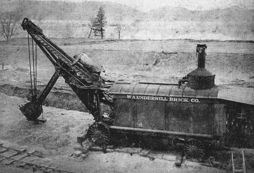
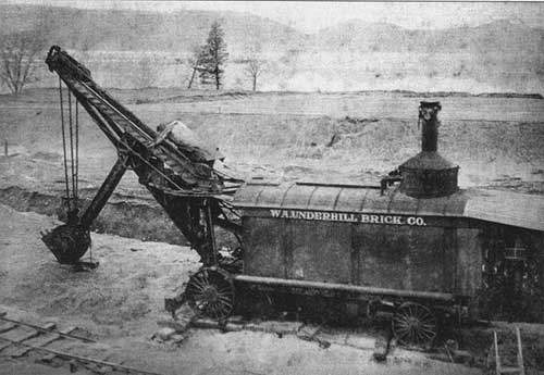
A steam shovel used for excavating clay at the William A. Underhill brickyard on Croton Point. By 1883, 13 brickyards were operating in the area, producing 64,000 bricks daily.
Date: c. 1890-1910
Location: Croton Point, Croton…
Scharf, J. Thomas, ed. History of Westchester County, New York, including Morrisania, Kings Bridge, and West Farms, which have been annexed to New York City, Vol. I. Philadelphia: L.E. Preston & Co., 1886.
…On the other side of the county, skirting Long
Island Sound, a widely ditfereiit panorama is presented,
but one which also has individual charms and beauties of its own. The shore line is broken into many
promontories or i)eninsulas…
Show 8 of 4798 matching passages
History of Westchester County, New York, Vol. I §3001
— …On the other side of the county, skirting Long
Island Sound, a widely ditfereiit panorama is presented,
but one which also has individual charms and beauties of its own. The shore line is broken into many
promontories or i)eninsulas…
History of Westchester County, New York, Vol. I §4322
— It is in contemplation by the city authorities to discontinue this bridge and King's Bridge, and erect
either a tunnel or one large bridge at the upper end
of Manhattan Island, but as yet the plans for this
change…
History of Westchester County, New York, Vol. I §1723
— …young gentlemen from
" the Island of Jamaica, one from Montreal, four
" children of gentlemen now in England, committed
" to his care, among others from New York and the
" country. That he apprehends his school to be
" broken up and his…
History of Westchester County, New York, Vol. I §4079
— The elevation of Fort W'ashington, the greatest on Manhattan Island, is two hundred and sixty-four feet.
3 So called after Jonas Bronck, the earliest white settler and proprietor
of "Bronck's Land," now Morriaania, Twenty-third Ward, New…
History of Westchester County, New York, Vol. I §4307
— …On the 23d a lively fight took place just hefore dusk in the broken groiuid near the south side of
the fort, probably on the Dykman farm. An ensign
and one man of the New York Militia were killed
and…
History of Westchester County, New York, Vol. I §263
— " And, whereas, it is the Company's intention first
to settle the Island of the Manhattes, it shall provisionally be the staple of all produce and wares
accruing on the North river and the country thereabout, before they can be…
History of Westchester County, New York, Vol. I §4078
— …It
has also been known as Mill Creek and Yonkers Hirer.
■-The highest ground within the limits of New York City. The elevation of Fort W'ashington, the greatest on Manhattan Island, is two hundred and sixty-four feet.
3…
History of Westchester County, New York, Vol. I §3279
— …Pryer, " he called out, 'doctor, I
have a broken arm.' Proceeding to examine the arm
very tenderly, fearful of giving pain, I said, 'are you
sure it is broken? ' 'Oh, yes,' said he, ' see here,' and
he shook the elbow…
Higgins, Alvin McCaslin. The Story of Croton. Paper read before the Ossining Historical Society, 1938. Published posthumously in The Quarterly Bulletin of the Westchester County Historical Society, Vol. 16, No. 3 (1940), pp. 49-63.
…In 1768, when the Methodist missionary, Thomas Ware, crossed
over from Long Island to Westchester to promote the Wesleyan faith,
he said, "there was not a Methodist on the east side of the Hudson
above New York,'' although the great…
Show 8 of 40 matching passages
The Story of Croton §21
— …In 1768, when the Methodist missionary, Thomas Ware, crossed
over from Long Island to Westchester to promote the Wesleyan faith,
he said, "there was not a Methodist on the east side of the Hudson
above New York,'' although the great…
The Story of Croton §20
— …Underhill began the
manufacture of brick there over a hundred years ago, and for more
than fifty years, enameled bricks for tiling and wainscoting made on
Croton Point were in great demand. Then the clay stratum was exhausted. For fifteen…
The Story of Croton §32
— …General Washington's spies on Long Island and
in New York. Brooklyn, N. Y., the Long Island Hist. Soc., 1939.
302 p. (Gift of Mr. D. Irving Mead.)
Poundridge, New York, Presbyterian Church. Marriages performed by
Reverend William Patterson, 1837…
The Story of Croton §5
— …the Hudson, to make a treaty with the Indians; then to
Connecticut to fix the boundary line; then out to Jamaica to treat with
the English who demanded Long Island. Olaf was the burgomaster of
New York when the English…
The Story of Croton §22
— In 1768, when the Methodist missionary, Thomas Ware, crossed
over from Long Island to Westchester to promote the Wesleyan faith,
he said, "there was not a Methodist on the east side of the Hudson
above New York,'' although the great…
The Story of Croton §6
— …the Hudson, to make a treaty with the Indians; then to
Connecticut to fix the boundary line; then out to Jamaica to treat with
the English who demanded Long Island. Olaf was the burgomaster of
New York when the English…
The Story of Croton §39
— …The objects of the Society as recited in the original articles of incorporation were: To obtain and preserve information pertaining to the history of the
United States of America, of the State of New York, and especially of the
County…
The Story of Croton §29
— COUNTY SOLDIERS' GRAVES LOCATED
A project under the direction of Mr. Thomas F. Hammond,
designed to locate the graves of Westchester County men who have
served in the thirty-two wars of this country and undertaken as a
joint project…
Bolton, Reginald Pelham. Indian Paths in the Great Metropolis. Indian Notes and Monographs, Vol. II, No. 7. New York: Museum of the American Indian, Heye Foundation, 1922.
…called, was the first
highway laid out through the length of
the island," and the remark is also made
that "the topographical character of the
AND MONOGRAPHS
INDIAN PATHS
island in this vicinity was of a broken or
rocky character…
Show 8 of 261 matching passages
Indian Paths in the Great Metropolis §54
— …called, was the first
highway laid out through the length of
the island," and the remark is also made
that "the topographical character of the
AND MONOGRAPHS
INDIAN PATHS
island in this vicinity was of a broken or
rocky character…
Indian Paths in the Great Metropolis §243
— See Post-road
Kips bay, 66, 67
Kissing Bridge, 66
Knoll, The, 80
Kolch hill, 44, 45, 47
Kolch pond, 44, 53, 54, 220
Konaande Kongh, Konaandekong, 63, 68, 70,
71, 221
Konstabelsche hook, 96. See Berrians neck
Kreischerville, 194…
Indian Paths in the Great Metropolis §248
— …See Macomb's Dam Park
Nut island, 238. See Governors island Nutten island
Nutten island, 238. See Governors island. Nut island
Oakwood, 195, 234
Observatory place, 66
Ocean parkway, 163
Oestdorp, 122. See Westchester
Old Boston Post-road, 120 See…
Indian Paths in the Great Metropolis §152
— …The eastern
island was at first known as Gysbert's
eylandt, and both were known as late as
1824 as Schryers hook.
The island was doubtless reached from
the mainland by a path which led direct
from the site of…
Indian Paths in the Great Metropolis §172
— That legend recorded the
pursuit by the natives of "Manetto,"
the Evil Spirit, through Westchester county
to the Sound shore, where, escaping to
City island, he stepped across to a safe
retreat on Long Island by the use of the…
Indian Paths in the Great Metropolis §78
— It has been
stated that oyster-shells were to be seen
upon the island, but of course they may
have been carried there in the extension of
its area.
By this means the path left the Island
of Manhattan. Only…
Indian Paths in the Great Metropolis §195
— …Furman, Gabriel, Antiquities of Long
Island.
24. RlNNEGACONCK, RlNNEGOCONCK. The
Delaware lenniga-xunk, or Bark-house
hill, is a satisfactory and distinctive
description, according with the native
settlement on the hill, the traces of which
were above described. -- M. R…
Indian Paths in the Great Metropolis §199
— …In
Transactions of the Long Island Historical
Society, vol. i, Brooklyn, 1867.
Strong, Thos. M., History of Flatbush, New
York, 1842.
Thompson, B. F., History of Long Island, 2d
ed., New York, 1843.
Tooker, William Wallace, The Indian Place
Names…