History / Search
255 passages in 38 source items for “Below the Dam”
Collection
All
🏹 Indigenous Peoples & Archaeology
📜 Colonial & Dutch Records
📖 Westchester County Histories
🏘️ Croton Local History
🏛️ Government Documents
crotonhistory.org
community known as The Bowery. Below is another view of the Bowery, looking north toward the dam, which can be seen in the distance. The label on the card incorrectly refers to the “Quaker Bridge Dam”, which was one of…
Show 3 matching passages
Bowery Bridge Below New Croton Dam §1
— community known as The Bowery. Below is another view of the Bowery, looking north toward the dam, which can be seen in the distance. The label on the card incorrectly refers to the “Quaker Bridge Dam”, which was one of…
Bowery Bridge Below New Croton Dam §0
— The wooden work bridge, built across the Croton River near today’s Route 129. The bridge was used to move men and supplies from the docks at Croton Landing up to the New Croton Dam worksite. The buildings along the…
Bowery Bridge Below New Croton Dam §2
— before the Cornell farm site was chosen. Share this: Print (Opens in new window) Print Email a link to a friend (Opens in new window) Email Share on Facebook (Opens in new window) Facebook Share on X (Opens in new…
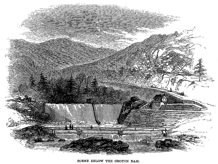
Harper's New Monthly Magazine / Wikimedia Commons
Scene Below the Croton Dam — Harper's Magazine (1860)
Engraving from T. Addison Richards' article 'The Croton Aqueduct' in Harper's New Monthly Magazine, December 1860. Shows the dramatic scenery below the Old Croton Dam with water cascading over the…
crotonhistory.org
enlarge it and then click the arrow icons to cycle through the images. View looking north Close-up of John Fish Detail showing the machine shops below the dam The machine shops below the dam (where the park is today…
Show 5 matching passages
New Croton Dam Construction Circa 1902 §5
— enlarge it and then click the arrow icons to cycle through the images. View looking north Close-up of John Fish Detail showing the machine shops below the dam The machine shops below the dam (where the park is today…
New Croton Dam Construction Circa 1902 §8
— river below the dam Other visitors to the dam Detail showing the man higher up the stairs looking through a pair of binoculars Detail showing the railroad tracks through the tunnel, used to bring stone to the face of the…
New Croton Dam Construction Circa 1902 §7
— suspension bridge Looking south at the construction area below the dam Detail showing stones stacked up next to the railroad tracks Detail showing another view of the machine shops Detail showing some construction buildings on the other side of the
New Croton Dam Construction Circa 1902 §10
— …Large chunks of stone on flat railcars, waiting to be transported through the tunnel to the face of the dam. This is probably the house of Aaron Cornell, along the original bank of the Croton River. The road below the…
New Croton Dam Construction Circa 1902 §3
— involved in the construction as a subcontractor but so far a search of online and offline sources has turned up nothing. If you have any information please send us an email . The scanned images below have been adjusted in Photoshop…
crotonfriendsofhistory.org
have been carried across the dam and bridge, from abutment to abutment, with fine architectural effect. Original bridge with spillway below. These, however, are minor defects and do not prevent the Croton Dam from ranking, not only as one of…
Show 6 matching passages
Water Over the Dam §25
— have been carried across the dam and bridge, from abutment to abutment, with fine architectural effect. Original bridge with spillway below. These, however, are minor defects and do not prevent the Croton Dam from ranking, not only as one of…
Water Over the Dam §29
— Croton Gorge Park below. One of the unique features is the s-shaped curve spillway, designed to be used as a waste channel for water coming over the top of the dam. New Croton Dam spillway. The last stone of…
Water Over the Dam §42
— Croton Dam and Reservoir, 2013. The structure was officially declared completed, including the road across the top and the park with fountain below, and turned over to the City of New York on New Year’s Day 1907. The design…
Water Over the Dam §28
— lowest point of the foundation 131 feet below the bed of the Croton River, ground level to top of dam 166 feet, total height 297 feet, thickness of the base 206 feet, thickness at the top 18 feet, and width…
Water Over the Dam §40
— chapel located along today’s Route 129 below the dam during the construction period. The Reverend mailed the trowels from Vatican City where he was residing at the time. January 17, 1906 – officials placing final stone on the spillway. The…
Water Over the Dam §41
— …When the waters have risen to the top of the new dam, the crest of the old dam will be 33 feet below the surface.” New
en.wikipedia.org
…At the time of its completion, it was the tallest dam in the world. [ 3 ] Its foundation extends 130 feet (40 m) below the bed of the river, and the dam contains
crotonhistory.org
…Click the image to enlarge it. New Croton Dam spillway, February, 1934. Click the image to enlarge it. Ice on the spillway of the New Croton Dam, February, 1934. Click the image to enlarge it. Croton River below the
crotonhistory.org
Supply—Present Condition of Work on the Great Croton River Dam.” Christopher Tompkins, author of The Croton Dams and Aqueduct , said this image is “especially noteworthy for its accuracy in depicting the excavation.” Below is the top section of the
crotonhistory.org
online courtesy of the Detroit Public Library, National Automotive History Collection. Bridge below the New Croton Dam, May 13, 1913. Courtesy of the Detroit Public Library, National Automotive History Collection. A number of other photos were taken
Show 2 matching passages
Drive To The New Croton Dam 1913 §3
— online courtesy of the Detroit Public Library, National Automotive History Collection. Bridge below the New Croton Dam, May 13, 1913. Courtesy of the Detroit Public Library, National Automotive History Collection. A number of other photos were taken
Drive To The New Croton Dam 1913 §4
— the same day but unfortunately most show the car on unidentifiable country roads. One exception is an image taken at the Croton Lake Station of the “Old Put”—the New York Central Railroad, Putnam Division—shown below. 2 The company…
crotonhistory.org
…Below are details from the image, showing the immense scale of the structure—made entirely of hand-hewn stone which was cut, moved and placed without the aid of modern construction equipment. The image comes from the George P.
brickcollecting.com
that a new Croton Dam should be built. (It was to be located about three miles below the old dam on the Croton River. It would cover an area of land 20 miles long) 1892 construction began on the new…
Show 2 matching passages
Croton on Hudson Bricks §113
— that a new Croton Dam should be built. (It was to be located about three miles below the old dam on the Croton River. It would cover an area of land 20 miles long) 1892 construction began on the new…
Croton on Hudson Bricks §59
— …Robert Underhill made his first move towards success by leasing water rights below a dam built along the river just above the Hudson. Along with the water rights,
King, Charles. A Memoir of the Construction, Cost, and Capacity of the Croton Aqueduct. New York: Charles King, 1843.
…about one
Brayton, the son of one of the dam contractors, perceiving
" Mr. Albert
o'clock, the danger to the people below the dam on the opposite side, by the continued
rise of the water at the dam, and believing…
Show 8 of 32 matching passages
A Memoir of the Construction, Cost, and Capacity of the Croton Aqueduct §511
— …about one
Brayton, the son of one of the dam contractors, perceiving
" Mr. Albert
o'clock, the danger to the people below the dam on the opposite side, by the continued
rise of the water at the dam, and believing…
A Memoir of the Construction, Cost, and Capacity of the Croton Aqueduct §576
— At 300 feet below the main dam, a second dam is in progress, which is to be 9 feet
high, constructed of timber, stone and gravel, which will set the water back over
the
of the main and form a…
A Memoir of the Construction, Cost, and Capacity of the Croton Aqueduct §512
— …about one
Brayton, the son of one of the dam contractors, perceiving
" Mr. Albert
o'clock, the danger to the people below the dam on the opposite side, by the continued
rise of the water at the dam, and believing…
A Memoir of the Construction, Cost, and Capacity of the Croton Aqueduct §513
— …These are all the losses which have
come to our knowledge on the Crotori River, and all the losses to everybody above and
below the dam, including the dam, are considerably inside of $75,000."
No other parts of the…
A Memoir of the Construction, Cost, and Capacity of the Croton Aqueduct §472
— …The aqueduct proceeds
from the Sing Sing tunnel, crossing both the aforesaid street and creek, from north to
south.
3d. An archway over the Highland turnpike, now highway, about eleven miles
below the Croton dam, of 20 feet span, and…
A Memoir of the Construction, Cost, and Capacity of the Croton Aqueduct §522
— …the apron at the toe of the dam, and thereby breaking the
force of the fall, by its action on a body of water, there has been constructed, at a point
300 feet below the main dam, a secondary dam…
A Memoir of the Construction, Cost, and Capacity of the Croton Aqueduct §359
— …the dam, yet we fear, that, in locking vessels up, more or less of the
salt water below the dam will follow them, and although the quantity may be comparatively small, the constant repetition of the operation, by the hundreds…
A Memoir of the Construction, Cost, and Capacity of the Croton Aqueduct §523
— …the apron at the toe of the dam, and thereby breaking the
force of the fall, by its action on a body of water, there has been constructed, at a point
300 feet below the main dam, a secondary dam…
Lossing, Benson John. The Hudson, from the Wilderness to the Sea. New York: Virtue & Yorston, 1866. Internet Archive identifier: hudsonfromwilder00lossi. Illustrated travel-history of the Hudson River valley by the writer and artist Benson J. Lossing, whose chapter on Teller's / Croton Point is a primary source for Senasqua place-name etymology, Sarah Teller's 1682 purchase, and the Underhill vineyard.
…These form a striking feature in the scene below the dam.
From the lock may be obtained an excellent view of the river below.
LOCK AT STATE DAM, TROY.
with the last of the bridges that then spanned the Hudson…
Show 8 of 20 matching passages
The Hudson, from the Wilderness to the Sea §158
— …These form a striking feature in the scene below the dam.
From the lock may be obtained an excellent view of the river below.
LOCK AT STATE DAM, TROY.
with the last of the bridges that then spanned the Hudson…
The Hudson, from the Wilderness to the Sea §119
— …The dam forms an elbow
in the middle of the stream, and is about 1,400
feet in length. Below it are considerable
rapids ; just above it is a bridge, which has a
carriage-way for the public use, and…
The Hudson, from the Wilderness to the Sea §93
— …miles below,
a day or two longer, for the purpose of visiting objects of interest in their
vicinity, a description of which will be given as we proceed with our
notes. A brief notice of the State Dam and Great…
The Hudson, from the Wilderness to the Sea §35
— …another similar shore a few miles below, were the only deposits of limestone that we saw in all that region.
At the outlet of Rich's Lake were the ruins of a dam and lumber
LUMBER DAM AND SLUICE
sluicj…
The Hudson, from the Wilderness to the Sea §405
— …Not having
time to visit the fountain reservoir, I have availed myself of the pencil
services of a friend, in giving a sketch of the dam from a point just
below it.
The Croton aqueduct runs parallel with the Iludson…
The Hudson, from the Wilderness to the Sea §359
— …the
evidence of coffers of specie below. This augur with its bits of silver was
THE HUDSON.
exhibited, and the story believed. A stock company was formed. Shares
were readily taken. The speculator was chief manager. A coffer dam
was…
The Hudson, from the Wilderness to the Sea §157
— …The dam also furnishes water power to a number of mills
on the Troy shore below it, into which grain is taken from vessels lying
at the docks, by means of "elevators" worked by the water wheels.
The Hudson, from the Wilderness to the Sea §2
— Elephant Island
Lumber Dam and Sluice
Initial Letter-- The Wayside Fountain
Eapids at the Head of Harris's Lake
Sandford Lake
The Iron Dam
Adirondack Village
Departure for Tahawus
First Bridge over the Hudson
Bark Cabin at Calamity Pond
Henderson…
Hill, William R. Modifications of the Plan of the New Croton Dam. Paper read before the American Water Works Association, St. Louis, Missouri, June 8, 1904. Pamphlet T 462, Cornell University Library.
A channel for the overflow is excavated in the rock back of the wall leading down to the river below the dam . The main stone dam , according to the original plan , was to be 600 feet long , extending from the…
Show 8 of 76 matching passages
Modifications of the Plan of the New Croton Dam §4
— A channel for the overflow is excavated in the rock back of the wall leading down to the river below the dam . The main stone dam , according to the original plan , was to be 600 feet long , extending from the…
Modifications of the Plan of the New Croton Dam §23
— A channel for the overflow is excavated in the rock back of the wall leading down to the river below the dam . The main stone dam , according to the original plan , was to be 600 feet long , extending from the…
Modifications of the Plan of the New Croton Dam §45
— A channel for the overflow is excavated in the rock back of the wall leading down to the river below the dam . The main stone dam , according to the original plan , was to be 600 feet long , extending from the…
Modifications of the Plan of the New Croton Dam §12
— …A channel for the overflow is excavated in the rock back of the wall leading down to the river below the dam . The main stone dam , according to the original plan , was to be 600 feet long , extending from the…
Modifications of the Plan of the New Croton Dam §33
— …A channel for the overflow is excavated in the rock back of the wall leading down to the river below the dam . The main stone dam , according to the original plan , was to be 600 feet long , extending from the…
Modifications of the Plan of the New Croton Dam §55
— …A channel for the overflow is excavated in the rock back of the wall leading down to the river below the dam . The main stone dam , according to the original plan , was to be 600 feet long , extending from the…
Modifications of the Plan of the New Croton Dam §5
— The lower portion of the inner slope to a height of 16 feet below the crest of the spillway , to be paved with stone , 18 inches thick , laid dry , upon 12 inches of broken stone , and on the upper part…
Modifications of the Plan of the New Croton Dam §14
— The lower portion of the inner slope to a height of 16 feet below the crest of the spillway , to be paved with stone , 18 inches thick , laid dry , upon 12 inches of broken stone , and on the upper part…
Tower, Fayette B. Illustrations of the Croton Aqueduct. New York: Wiley and Putnam, 1843.
…is a view taken from a point below the dam
and shows the relative positions of the dam and the gate
chamber at the head of the Aqueduct. The original channel of the River where the dam is built,
;
was…
Show 8 of 19 matching passages
Illustrations of the Croton Aqueduct §123
— …is a view taken from a point below the dam
and shows the relative positions of the dam and the gate
chamber at the head of the Aqueduct. The original channel of the River where the dam is built,
;
was…
Illustrations of the Croton Aqueduct §87
— This dam was proposed to
be built about 2 feet above the level of high tide, thereby
keeping all the salt water below ; and above the dam would
be the fresh water for supplying the city, which must be
pumped…
Illustrations of the Croton Aqueduct §138
— …The water is set back at this place by a dam for a mill a
short distance below, giving the stream an appearance of
more magnitude than it really possesses. This point is 25
miles from the dam. The wall…
Illustrations of the Croton Aqueduct §124
— …is a view taken from a point below the dam
and shows the relative positions of the dam and the gate
chamber at the head of the Aqueduct. The original channel of the River where the dam is built,
;
was…
Illustrations of the Croton Aqueduct §129
— …This secondary dam is
formed of round timber, brush wood, and gravel ; it may be
seen in the picture directly under the bridge which extends
across below the main structure. On the upstream side of the masonry of the dam…
Illustrations of the Croton Aqueduct §99
— At the place where it was determined to build the dam
across the Croton River, the surface of the natural flow of
water was about 38 feet below the elevation required as a
head for the water to flow into…
Illustrations of the Croton Aqueduct §115
— …of the hill against
which the masonry of the dam is built, a distance of over
200 feet. This tunnel descends into the Reservoir, so that
the centre of it at the mouth is about 12 feet below the sur…
Illustrations of the Croton Aqueduct §98
— …At the place where it was determined to build the dam
across the Croton River, the surface of the natural flow of
water was about 38 feet below the elevation required as a
head for the water to flow into…
Scharf, J. Thomas, ed. History of Westchester County, New York, including Morrisania, Kings Bridge, and West Farms, which have been annexed to New York City, Vol. II. Philadelphia: L.E. Preston & Co., 1886.
Pathfinder Dam and Reservoir
The Pathfinder dam and reservoir is located about three miles below the junction of
the Sweetwater with the North Platte near
the old Overland Trail, and is named in
honor of John C. Fremont, who was…
Show 8 of 9 matching passages
History of Westchester County, New York, Vol. II §1363
— Pathfinder Dam and Reservoir
The Pathfinder dam and reservoir is located about three miles below the junction of
the Sweetwater with the North Platte near
the old Overland Trail, and is named in
honor of John C. Fremont, who was…
History of Westchester County, New York, Vol. II §1781
— …below any possible seams
in the formation. In this trench was built a
concrete core for the dam. The length of the
dam is 4,000 feet and the maximum fill is
sixty-five feet. The top oi the dam…
History of Westchester County, New York, Vol. II §1780
— …below any possible seams
in the formation. In this trench was built a
concrete core for the dam. The length of the
dam is 4,000 feet and the maximum fill is
sixty-five feet. The top oi the dam…
History of Westchester County, New York, Vol. II §1362
— …Pathfinder Dam and Reservoir
The Pathfinder dam and reservoir is located about three miles below the junction of
the Sweetwater with the North Platte near
the old Overland Trail, and is named in
honor of John C. Fremont, who was…
History of Westchester County, New York, Vol. II §1463
— by the opening of the fall term. Electric power
is supplied from up the valley, but with the
completion of the huge government project below the Pathfinder dam it is thought that current may be taken in charge by the…
History of Westchester County, New York, Vol. II §1364
— Just below the mouth of Whalen canyon, and about eight miles up the river from
the site of old Fort Laramie, is a diversion
dam of concrete 325 feet long with an extreme height of 35 feet, and from the…
History of Westchester County, New York, Vol. II §1462
— …Electric power
is supplied from up the valley, but with the
completion of the huge government project below the Pathfinder dam it is thought that current may be taken in charge by the city. The
erection of a $75,000…
History of Westchester County, New York, Vol. II §521
— …And just below the ranch house in the creek are still some
rocks that were piled there in the indifferent
but substantial manner of lazy cowboys, to
form a sort of a dam for raising the water level
in the…
Bolton, Robert Jr. The History of the Several Towns, Manors, and Patents of the County of Westchester, from its First Settlement to the Present Time, Vol. I. New York: Charles F. Roper, 1881. Revised posthumous edition.
The course of the Bronx immediately below the mill is said to have
been formerly changed by a large beaver dam, which those industrious
animals had erected near die foot of Mr. Underbill's garden. Beaver
Pond lies directly north…
Show 5 matching passages
The History of the Several Towns, Manors, and Patents of the County of Westchester (1881 revised edition, Vol. I) §646
— The course of the Bronx immediately below the mill is said to have
been formerly changed by a large beaver dam, which those industrious
animals had erected near die foot of Mr. Underbill's garden. Beaver
Pond lies directly north…
The History of the Several Towns, Manors, and Patents of the County of Westchester (1881 revised edition, Vol. I) §62
— …came the dreaded Mohawk, above which towers the mighty Dundenburg, in olden times abounding in game which the Indians hunted for
pleasure and subsistence, which, together with the beautiful valleys of
the Myanos and the Muscoota or Beaver Dam and…
The History of the Several Towns, Manors, and Patents of the County of Westchester (1881 revised edition, Vol. I) §76
— …Another mill seems to have
become necessary at this time, for in November 1701, "the town by a
maigor vote doth agree that their corn mill shall be set upon beucr dam
Riuerat the first conueniant place below davids broock…
The History of the Several Towns, Manors, and Patents of the County of Westchester (1881 revised edition, Vol. I) §645
— …25 1
carry the mill throughout the year, which enables it to grind at all seasons.
The course of the Bronx immediately below the mill is said to have
been formerly changed by a large beaver dam, which those industrious…
The History of the Several Towns, Manors, and Patents of the County of Westchester (1881 revised edition, Vol. I) §77
— Another mill seems to have
become necessary at this time, for in November 1701, "the town by a
maigor vote doth agree that their corn mill shall be set upon beucr dam
Riuerat the first conueniant place below davids broock…
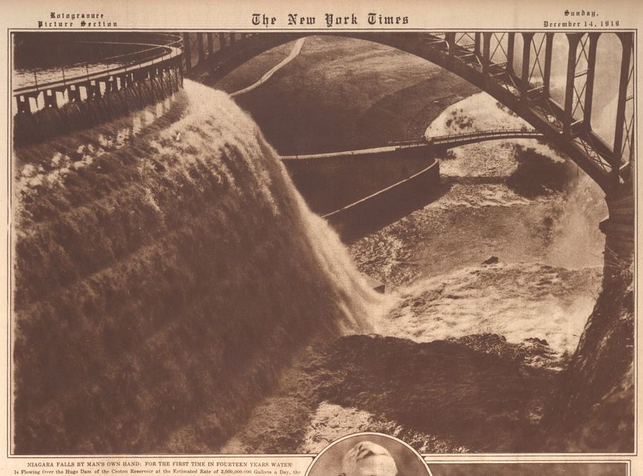
crotonhistory.org — https://crotonhistory.org/2016/02/17/niagara-falls-by-mans-own-hand/
…the first time in fourteen years water is flowing over the huge dam of the Croton Reservoir at the estimated rate of 2,000,000,000 gallons a day, the vast tide dropping to the Croton River, 150 feet below…
crotonhistory.org
…the first time in fourteen years water is flowing over the huge dam of the Croton Reservoir at the estimated rate of 2,000,000,000 gallons a day, the vast tide dropping to the Croton River, 150 feet below…
O'Callaghan, E.B., ed. The Documentary History of the State of New York, Vol. IV. Albany: Weed, Parsons and Co., 1851.
P, A Sluice and Dam to raise a head of water to float Batteaus
to Fort Bull.
Q. A wood Dam made by a Prodigious number of trees thrown
there Promiscuously by Freshes
R. The Oswegagie Indian Path.
be 2…
Show 4 matching passages
Documentary History of the State of New York, Vol. IV §979
— P, A Sluice and Dam to raise a head of water to float Batteaus
to Fort Bull.
Q. A wood Dam made by a Prodigious number of trees thrown
there Promiscuously by Freshes
R. The Oswegagie Indian Path.
be 2…
Documentary History of the State of New York, Vol. IV §978
— …The Middle Creek, has its head at a spring and joins the
above Creek a little below the Fort.
I. The Saw Mill Dam
K. The Mill Race
L. The Waste Race
M. The Road from the Mahawk River over…
Documentary History of the State of New York, Vol. IV §975
— …Bult. . /
Springs. @ A Wood Dam made bya Frodigtous es | 74ts Interwal is stoma ay
Ho The Midd le Creck. has tshead ata Spring, Number of trees: thrown there Fro - |
and joins the ahove Creck a tittle below merscuously by lreshes.
Documentary History of the State of New York, Vol. IV §976
— …Dam made bya Frodigtous es | 74ts Interwal is stoma ay
Ho The Midd le Creck. has tshead ata Spring, Number of trees: thrown there Fro - |
and joins the ahove Creck a tittle below merscuously by lreshes.
the Fort. R. The…
Scharf, J. Thomas, ed. History of Westchester County, New York, including Morrisania, Kings Bridge, and West Farms, which have been annexed to New York City, Vol. I. Philadelphia: L.E. Preston & Co., 1886.
…The Renwicks then brought suit in the Superior Court to recover from Morris the damages for
his alleged trespass, but on the trial the judge charged
the jury that the dam as built was a public nuisance
and that any…
Show 4 matching passages
History of Westchester County, New York, Vol. I §4332
— …The Renwicks then brought suit in the Superior Court to recover from Morris the damages for
his alleged trespass, but on the trial the judge charged
the jury that the dam as built was a public nuisance
and that any…
History of Westchester County, New York, Vol. I §3737
— …neighborhood, and
on the day of his death he had wandered to the old
mill, and was sitting upon the dam with his pole,
when, by some mischance, he fell from his position to
the rocks below, dying shortly thereafter…
History of Westchester County, New York, Vol. I §3736
— …neighborhood, and
on the day of his death he had wandered to the old
mill, and was sitting upon the dam with his pole,
when, by some mischance, he fell from his position to
the rocks below, dying shortly thereafter…
History of Westchester County, New York, Vol. I §4348
— …the King's road
below the hill on P''ordham Manor to the highway
leading to the Fordham Meeting-house. The meetinghouse which was the old J)utch Church formerly
stood at the junction of the Macomb's Dam road…
illustrations_aqueduct_raw.txt
…is a view taken from a point below the dam and shows the relative positions of the dam and the gate chamber at the head of the Aqueduct. The original channel of the River where the dam is built, X…
Show 8 of 12 matching passages
illustrations_aqueduct_raw §34
— …is a view taken from a point below the dam and shows the relative positions of the dam and the gate chamber at the head of the Aqueduct. The original channel of the River where the dam is built, X…
illustrations_aqueduct_raw §23
— …This dam was proposed to be built about 2 feet above the level of high tide, thereby keeping all the salt water below ; and above the dam would be the fresh water for supplying the city, which must be pumped…
illustrations_aqueduct_raw §38
— …The water is set back at this place by a dam for a mill a short distance below, giving the stream an appearance of more magnitude than it really possesses. This point is 25 miles from the dam. The wall…
illustrations_aqueduct_raw §35
— …This secondary dam is formed of round timber, brush wood, and gravel ; it may be seen in the picture directly under the bridge which extends across below the main structure. On the upstream side of the masonry of the dam…
illustrations_aqueduct_raw §32
— …The bottom of the water-way of the Aqueduct at the gate chamber where it enters the Receiving Reservoir, is 7.86 feet below the level of top water line in the Reservoir, thus when the Reservoir is full the…
illustrations_aqueduct_raw §36
— dam, an em- bankment of earth is filled in, extending 275 feet from the masonry at the base, and extending from the masonry with a slope of 1 foot in 5 on the top. The whole work about the dam…
illustrations_aqueduct_raw §37
— …the dam. This stream enters the Hudson River about two miles below Tarrytown. The distance from the mouth of the stream to the line of Aqueduct is only a quarter of a mile. Plate XVI. is a view of the…
illustrations_aqueduct_raw §41
— …ley, which is about 35 miles from the Croton dam. This valley is four fifths of a mile wide where the Aqueduct meets it, and the depression is 102 feet below the plane of Aqueduct grade. Here was an opportunity…
Various (1971)
— original
…Since both of these sites lay below the proposed flood level of the river it was decided to excavate them before the completion of the dam. The Witchs Walk Sites, as they came to be called, are located on the…
Bolton, Robert Jr. The History of the Several Towns, Manors, and Patents of the County of Westchester, from its First Settlement to the Present Time, Vol. II. New York: Charles F. Roper, 1881.
…The cost of which is estimated at . . . " .
£350
eo
£1,650
Pines Bridge crosses the lake about one mile above the dam. Ou
the south side of the Croton is a small settlement bearing the name of
Crotonville -- which contains…
O'Callaghan, E.B., ed. The Documentary History of the State of New York, Vol. III. Albany: Weed, Parsons and Co., 1850.
…At some distance
below this dam and lock, a canal may be led from the river on
the south side, secured with guard gates, and run througli low
lands, and well slieltered along the foot of tlie hills and re…
Show 5 matching passages
Documentary History of the State of New York, Vol. III §1982
— …At some distance
below this dam and lock, a canal may be led from the river on
the south side, secured with guard gates, and run througli low
lands, and well slieltered along the foot of tlie hills and re…
Documentary History of the State of New York, Vol. III §1216
— …Carrying a
Peece of ye old Damm with it, and came down with such force
yt had like to Carry both Saw Mill & Corn miU & Dam and all,
for ye Ise being Strong below ye Dam, stopd ye water w…
Documentary History of the State of New York, Vol. III §1217
— Carrying a
Peece of ye old Damm with it, and came down with such force
yt had like to Carry both Saw Mill & Corn miU & Dam and all,
for ye Ise being Strong below ye Dam, stopd ye water w…
Documentary History of the State of New York, Vol. III §1983
— At some distance
below this dam and lock, a canal may be led from the river on
the south side, secured with guard gates, and run througli low
lands, and well slieltered along the foot of tlie hills and re…
Documentary History of the State of New York, Vol. III §1980
— …the river, from the deep water just above the mouth of
Schohara Creek, and on the north side of the river, until it shall
descend the river as far as to gain height sufficient to enter the
bank below the…
Ruttenber, E.M. Footprints of the Red Men: Indian Geographical Names in the Valley of Hudson's River, the Valley of the Mohawk, and on the Delaware. Published in the Proceedings of the New York State Historical Association, Vol. VI. 1906.
…On the 9th of August ^Clinton's forces embarked and the dam
was cut. The opening of the dam made very high water, flooding
the flats down the river and frightening the Indians, who thoug'ht
the Great Spirit was…
Show 3 matching passages
Footprints of the Red Men: Indian Geographical Names §44
— …On the 9th of August ^Clinton's forces embarked and the dam
was cut. The opening of the dam made very high water, flooding
the flats down the river and frightening the Indians, who thoug'ht
the Great Spirit was…
Footprints of the Red Men: Indian Geographical Names §570
— …in the town of Chester,
^ Van Dam Patent (1709) and Mompesson Patent (1709-12). The late
Hon. George W. Tuthill wrote me in 1858 : "On the northwestern bank of
Murderers' Creek, about half a mile below Washingtonville, stands the dwelling…
Footprints of the Red Men: Indian Geographical Names §750
— …weir or dam for impounding fish. Such dams or fishing places became boundmarks in some cases. The name was corrupted to Nomin-ack, as the name of a church
and of a fort three or four miles below what is…
Macdonald, John. Interview with Horton, John, 1780-1854; (1848-12-14). Experiencing the Neutral Ground of the American Revolution: The McDonald Interviews, WCHS item 848. Transcription courtesy of the Westchester County Historical Society (No copyright - United States).
…The bridge built by
the British at the battle of White Plains
was below Azariah Horton's Saw Mill
the Bronx. Poplar and other trees were
felled for the purpose of constructing it.
The
heavy stone wall at the head…
old_croton_aqueduct_raw.txt
distance of about three miles carrying away m its course, Quaker bridge, Holman 's mills, and the old piers of the old Croton bridge.... All the bridges below the dam were carried away, and above the dam. Pines Bridge, and…
Show 8 of 9 matching passages
old_croton_aqueduct_raw §31
— distance of about three miles carrying away m its course, Quaker bridge, Holman 's mills, and the old piers of the old Croton bridge.... All the bridges below the dam were carried away, and above the dam. Pines Bridge, and…
old_croton_aqueduct_raw §17
— …Ogee Shape of the Weir Overflow figure 25. below left: Lt. Theophilus Schramke. Croton Dam Design — Cross Section of Ogee Curve, engraving In Description of the Sen' York Croton Aqueduct in English, German and French, 1846 Courtesy William Lee Frost…
old_croton_aqueduct_raw §30
— …All the bridges below the dam were carried away, and above the dam. Pines Bridge, and we are informed Wood's Bridge also — leaving no crossing over the Croton from its mouth to Golden's bridge ....■^^ The newspaper account provides…
old_croton_aqueduct_raw §10
— …much below on the other (figure 13). No great varia- tion would have been possible. Jervis also concurred with the loca- tion of the dam at Garretson's Mill, seven miles upstream from the Croton's junction with the Hudson…
old_croton_aqueduct_raw §44
— …Tower, View above the Croton Dam, From Illustrations of the Croton Aqueduct, 1843 Engraved by William James Bennett; 5V2X 10 V2 Inches (Image) Ossining Historical Society Museum Fayette B. Tower, View below the Croton Dam, From Illustrations of the Croton…
old_croton_aqueduct_raw §18
— …the arch to a series of brick arches just below the line of the Aqueduct. Thus, any water leaking from the Aqueduct would pass into the void area and exit from the masonry work before it could do any dam…
old_croton_aqueduct_raw §11
— …Farley figure 15, below: Robert Havell. Jr., View of Croton Dam. engraved by Henry Jordan & Frederick Halpin, frontispiece from Charles King's A Memoir of the Construction, Costs and Capacity of the Croton Aqueduct .... New York. 1843 The Hudson River…
old_croton_aqueduct_raw §33
— …Steinberg, "Dam Breaking in the 19th Century Merrimack Valley: Water, Social Conflict, and the Waltham Valley," The Journal of Social History v.24 (Fall 1990). #1, 31. The argument is more fully developed in Steinberg's Nature Incorporated: Industrialization and…
Shonnard, Frederic, and W.W. Spooner. History of Westchester County, New York, from its Earliest Settlement to the Year 1900. New York: The New York History Company, 1900.
…the
night of the 7th of January, 1841, in consequence of a sudden and
great rise in the water of the Groton, the portion of the dam comprised in the earthen embankment gave way, and the whole country
below was…
Show 8 of 10 matching passages
History of Westchester County, New York, from its Earliest Settlement to the Year 1900 §1136
— …the
night of the 7th of January, 1841, in consequence of a sudden and
great rise in the water of the Groton, the portion of the dam comprised in the earthen embankment gave way, and the whole country
below was…
History of Westchester County, New York, from its Earliest Settlement to the Year 1900 §1131
— …The line was divided into four divisions, the first extending from the Croton ten and one-half miles
to below Sing Sing, the second ten miles farther to Hastings, the
third ten miles to Fordham Church, and the fourth ten…
History of Westchester County, New York, from its Earliest Settlement to the Year 1900 §1120
— Brown's plan was to dam the Bronx about half a mile below
Williams's Bridge. Calculating, however, that the elevation
the
Bronx at that point was not sufficient to admit of drawing the of
water
to the city by…
History of Westchester County, New York, from its Earliest Settlement to the Year 1900 §1137
— …the
night of the 7th of January, 1841, in consequence of a sudden and
great rise in the water of the Groton, the portion of the dam comprised in the earthen embankment gave way, and the whole country
below was…
History of Westchester County, New York, from its Earliest Settlement to the Year 1900 §551
— …About 1700 he dammed Tippet's
Brook, thus creating the present Van Cortlandt Lake; and probably
not long afterward he erected below the dam the Van Cortlandt mill,
which until as recent a date as 1889 (when it came into…
History of Westchester County, New York, from its Earliest Settlement to the Year 1900 §1125
— They marked out a route from Macomb's
Dam to the Bronx River, which they declared to be the proper one
for the long desired supply, and added: "The Croton cannot be
brought in by this route, and cannot ever…
History of Westchester County, New York, from its Earliest Settlement to the Year 1900 §1124
— …They marked out a route from Macomb's
Dam to the Bronx River, which they declared to be the proper one
for the long desired supply, and added: "The Croton cannot be
brought in by this route, and cannot ever…
History of Westchester County, New York, from its Earliest Settlement to the Year 1900 §1119
— …Weston, the engineer of the canal companies
of the State, was employed to thoroughly inquire into the matter. Dr. Brown's plan was to dam the Bronx about half a mile below
Williams's Bridge. Calculating, however, that the elevation…
Bolton, Robert Jr. A History of the County of Westchester, from its First Settlement to the Present Time, Vol. II. New York: Alexander S. Gould, 1848.
…The following report of the engineers is entitled :
" Estimate of expense to make the Croton river navigable for boats of two
tons."
The falls at Croton river with a lock, £350
The falls below the Old bridge, 250
Small rapid…
Show 2 matching passages
A History of the County of Westchester, Vol. II §805
— …The following report of the engineers is entitled :
" Estimate of expense to make the Croton river navigable for boats of two
tons."
The falls at Croton river with a lock, £350
The falls below the Old bridge, 250
Small rapid…
A History of the County of Westchester, Vol. II §806
— The following report of the engineers is entitled :
" Estimate of expense to make the Croton river navigable for boats of two
tons."
The falls at Croton river with a lock, £350
The falls below the Old bridge, 250
Small rapid…
croton_waterworks_raw.txt
…Current Designation(s) Sign MUSCOOT DAM 1905 Plate 15-, New Croton Aqueduct Current Designation(s) MILL RIVER WASTE WEIR 1837-1841 Plate 22-6, Old Croton Aqueduct Spanning a depression 72 feet below grade, the Mill River Culvert’s 172…
Show 8 of 9 matching passages
croton_waterworks_raw §53
— …Current Designation(s) Sign MUSCOOT DAM 1905 Plate 15-, New Croton Aqueduct Current Designation(s) MILL RIVER WASTE WEIR 1837-1841 Plate 22-6, Old Croton Aqueduct Spanning a depression 72 feet below grade, the Mill River Culvert’s 172…
croton_waterworks_raw §47
— …Type Significance(s) Interpretation Sign Current Designation(s) Interpretation Current Designation(s) AMAWALK GATEHOUSE 1889-1896 Plate 9-, New Croton Aqueduct Located south of the main dam, the gatehouse receives water from the tower and sends it to the fountain…
croton_waterworks_raw §52
— …Old Croton Aqueduct Residing 105 feet below the Old Croton Aqueduct’s grade, Manhattan Valley, two miles south of High Bridge, was traversed by an inverted siphon of cast iron pipes. MIDDLE BRANCH DAM 1874-1878 Plate 4-, New Croton…
croton_waterworks_raw §49
— …11 COAL WHARF c 1890s (Demolished) Plate 29, New Croton Aqueduct Type A wharf on the Harlem River below Shaft Number 25 that received coal shipments to power the engines in the pump house and Shaft Number 25. Type Significance…
croton_waterworks_raw §58
— …a bed 40 feet below the Old Croton Aqueduct conduit. 42 Sign Current Designation(s) TITICUS DAM 1890-1895 Plate 7-, New Croton Aqueduct The Titicus Dam stretches 1,519 feet. The masonry portion, including the spillway, is 732 feet…
croton_waterworks_raw §44
— …Old Croton Dam: Completed by John B. Jervis in 1842, but later submerged underwater after the construction of the New Croton Dam in 1905; Now located about thirty feet below the water's surface in the new dam. P Panic…
croton_waterworks_raw §1
— …The Great Fire of 1835 and the cholera epidemic of 1832 (a victim of whom is illustrated below) were two of the most catastrophic instances of these periodic phenomena; occurring on the eve of the construction of the Croton system…
croton_waterworks_raw §51
— …as the Highland Turnpike, nearly eleven miles south of the Old Croton Dam. Type Sign Current Designation(s) Type Current Designation(s) Interpretation Structure Guide Rugged in landscape, the original park wrapped around the High Service Reservoir. At the turn…