History / Search
37927 passages in 1431 source items for “Blue Mountain, before the trail map”
Collection
All
🏹 Indigenous Peoples & Archaeology
📜 Colonial & Dutch Records
📖 Westchester County Histories
🏘️ Croton Local History
🏛️ Government Documents
No passages matched all of those words — showing passages that match any of them, best matches first.
Scharf, J. Thomas, ed. History of Westchester County, New York, including Morrisania, Kings Bridge, and West Farms, which have been annexed to New York City, Vol. II. Philadelphia: L.E. Preston & Co., 1886.
…the territory around about Sixty-six mountain, as one of danger and death, long before
the mountain was named. A spot upon the
map of the world when conflict and homicide
seemed inevitable and frequent. It was shunned by the…
Show 8 of 2111 matching passages
History of Westchester County, New York, Vol. II §368
— …the territory around about Sixty-six mountain, as one of danger and death, long before
the mountain was named. A spot upon the
map of the world when conflict and homicide
seemed inevitable and frequent. It was shunned by the…
History of Westchester County, New York, Vol. II §369
— The fame of the mountain does not extend
far across the wide reaches of western prairie,
except along the Texas trail, where from the
Panhandle of the Lone Star state to Assinnaboine, the cow-punchers knew of the Daters
and…
History of Westchester County, New York, Vol. II §367
— …Ingraham, and others have said that
the mountain was named before the Daters
appeared in this country. The thrilling events
that led to the naming of mountain forms another chapter in the history of the west. It
was one of…
History of Westchester County, New York, Vol. II §379
— …They took refuge in the hills and fought long
and hard. It was days before the remnant of
the sixty-six were overcome near a spring on
the north side of the mountain, and here it
was that Ed. Stemler…
History of Westchester County, New York, Vol. II §376
— …I had heard of it before, but had never
heard the story in its entirety until the side
partner of "Shanghai" Pierce, dropped a few
words that put me on the trail.
It was after the Union Pacific was builded…
History of Westchester County, New York, Vol. II §584
— …the canyons, and this creek crossing, with its
cooling little grove of mountain ash, was a
stopping place after the long hard, hot drive,
over the tablelands from Sidney.
The Sidney-Black Hills trail struck the valley of the North…
History of Westchester County, New York, Vol. II §377
— I had heard of it before, but had never
heard the story in its entirety until the side
partner of "Shanghai" Pierce, dropped a few
words that put me on the trail.
It was after the Union Pacific was builded…
History of Westchester County, New York, Vol. II §383
— …years before, is an explanation satisfactory to many old plainsmen, who have heard
Voices out of the past, when alone in the silence of the prairie.)
THE RIDE OF DAN DILLON AND OTHERS-- THE START OF THE TENAS TRAIL
A…

Historical Map
[Historical Map] Frontispiece of Indian Paths showing trail map of greater New York area

Historical Map
[Historical Map] Page from Bolton 1922 showing indigenous trail routes through Westchester

Historical Map
[Historical Map] Page from Bolton 1922 with trail descriptions near Croton area
Bolton, Reginald Pelham. Indian Paths in the Great Metropolis. Indian Notes and Monographs, Vol. II, No. 7. New York: Museum of the American Indian, Heye Foundation, 1922.
…the Bergen peninsula was best situated
to foot travel toward the mountain
regions north and west.
117. Marechkawick or Mareyckawick( Map
VIII, A). The headquarters of the
chieftaincy of that name, probably situated on the main trail from the ferry…
Show 8 of 261 matching passages
Indian Paths in the Great Metropolis §225
— …the Bergen peninsula was best situated
to foot travel toward the mountain
regions north and west.
117. Marechkawick or Mareyckawick( Map
VIII, A). The headquarters of the
chieftaincy of that name, probably situated on the main trail from the ferry…
Indian Paths in the Great Metropolis §2
— Van Cortlandt avenue, once the
Indian Shore path 116
INDIAN NOTES
ILLUSTRATIONS
XIII. Acqueanounck, the Hutchinson
river, where the Shore path
crossed 120
XIV. The old Eastchester and Westchester road, once the Indian
trail from the Siwanoy settlements 122
XV…
Indian Paths in the Great Metropolis §224
— …the Bergen peninsula was best situated
to foot travel toward the mountain
regions north and west.
117. Marechkawick or Mareyckawick( Map
VIII, A). The headquarters of the
chieftaincy of that name, probably situated on the main trail from the ferry…
Indian Paths in the Great Metropolis §187
— …and the sea coast with the
mountain regions of upper New Jersey in
which the Lenni Lenape made their home. This great pathway was so well known a
INDIAN NOTES
BOLTON-- INDIAN PATHS IN THE GREAT METROPOLIS
Original map of…
Indian Paths in the Great Metropolis §201
— …Hudson River, The, between New York and
Albany. Goodrich, 1824. Hudson River, Topographical map of the.
Lloyd, 1864. Hudson River Valley, The. Atlas. Watson,
1891. Indian Trails. Map in Charles A. Hanna's
The Wilderness Trail, New York, 1911. Manhattan…
Indian Paths in the Great Metropolis §135
— …If the natives were accustomed to visit Greenpoint, this old track
doubtless followed their woodland trail. It was certainly the first path trodden by the
white men in that district.
INDIAN NOTES
VI-- THE HOME-LANDS OF THE
CANARSEE
(Map…
Indian Paths in the Great Metropolis §13
— …the "war-path," which has passed into
colloquial reference, was more likely the
trail of the wild animal of the forest, or
some little-used passage by mountain and
water-course, than the trodden path through
villages, where the camp…
Indian Paths in the Great Metropolis §111
— …trail, which
connected the settlements on the East
•
AND MONOGRAPHS
INDIAN PATHS
River shore and necks in the southeastern
part of the Borough with the Eastchester
station and the Shore path (Map VII, B, D). Jenkins says, "Before the days…
croton_waterworks_raw.txt
…One of our plans to visually connect the entire Croton System is through the painting of a temporary blue line through the streets of New York City and on the Croton trail through the Bronx and Westchester County to show…
Show 8 of 60 matching passages
croton_waterworks_raw §27
— …One of our plans to visually connect the entire Croton System is through the painting of a temporary blue line through the streets of New York City and on the Croton trail through the Bronx and Westchester County to show…
croton_waterworks_raw §28
— …These sequential site numbers will emphasize the continuity of the Croton trail, and encourage people to explore other sites along the trail as well. A map with all of the numbered sites will be located on our website, and the…
croton_waterworks_raw §39
— …The Friends of the Old Croton Aqueduct have also published a map detailing the route of the Croton Aqueduct trail and attractions along the way. An ongoing project is the restoration and adaptive reuse of the keeper’s house in…
croton_waterworks_raw §38
— …The Friends of the Old Croton Aqueduct have also published a map detailing the route of the Croton Aqueduct trail and attractions along the way. An ongoing project is the restoration and adaptive reuse of the keeper’s house in
croton_waterworks_raw §20
— …While the intended audiences for these interpretation methods include visitors (to the trail in Westchester and the Bronx as well as other particularly significant sites in Manhattan) as well as the people living around the system, local populations remain largely…
croton_waterworks_raw §37
— …The trail begins on the south side of the New Croton Dam, farthest from the spillway, and works its way down following the path the aqueduct took from the dam to New York City. The trail offers a scenic walk…
croton_waterworks_raw §21
— …Although all have been demolished in New York City, many are extant along the Old Croton Aqueduct Trail in Westchester County. These ventilators may be used as part of a circuit-training course, with an associated map or signage developed…
croton_waterworks_raw §40
— …Mellon Foundation supplies funding for projects related to conservation and the environment, which could be useful in restoring the historic landscape of the Croton trail and its many parks and natural features. A few other sources of funding that have…
Bolton, Reginald Pelham. Indian Paths in the Great Metropolis. New York: Museum of the American Indian, Heye Foundation, 1922.
…the Bergen peninsula was best situated
to foot travel toward the mountain
regions north and west.
117. Marechkawick or Mareyckawick( Map
VIII, A). The headquarters of the
chieftaincy of that name, probably situated on the main trail from the ferry…
Show 8 of 106 matching passages
Indian Paths in the Great Metropolis §79
— …the Bergen peninsula was best situated
to foot travel toward the mountain
regions north and west.
117. Marechkawick or Mareyckawick( Map
VIII, A). The headquarters of the
chieftaincy of that name, probably situated on the main trail from the ferry…
Indian Paths in the Great Metropolis §78
— …the Bergen peninsula was best situated
to foot travel toward the mountain
regions north and west.
117. Marechkawick or Mareyckawick( Map
VIII, A). The headquarters of the
chieftaincy of that name, probably situated on the main trail from the ferry…
Indian Paths in the Great Metropolis §18
— …Its line was adopted as one,, of
the village streets, and as such was long
known as "the Indian trail" (see Map IV). Riker records the discovery, in 1855, at
a point between 120th and 121st streets,
on the same…
Indian Paths in the Great Metropolis §58
— …Hudson River, The, between New York and
Albany. Goodrich, 1824. Hudson River, Topographical map of the. Lloyd, 1864. Hudson River Valley, The. Atlas. Watson,
1891. Indian Trails. Map in Charles A. Hanna's
The Wilderness Trail, New York, 1911. Manhattan…
Indian Paths in the Great Metropolis §66
— …A principal station of
the Reckgawawanc chieftaincy which
was probably situated near the outlet
of the Neperah river, not far from Getty
square, being thus close to the line of the
Hudson River trail.
21. Eastchester (Map VII, A). A…
Indian Paths in the Great Metropolis §80
— …The name indicates
it as a sort of boundary place where the
territory of the Weckquaesgeek and
Siwanoy met.
121. Seton falls (Map VII, A). Near the
bend of Rattlesnake creek, on the Seton
estate, there is a cave, near…
Indian Paths in the Great Metropolis §28
— …necks in the southeastern
part of the Borough with the Eastchester
station and the Shore path (Map VII, B, D). Jenkins says, "Before the days of theOestdorp (Westchester) settlers it was a trail
or path used by the Siwanoy." 18…
Indian Paths in the Great Metropolis §47
— …From Pompton an old roadway, possibly
the successor of a trail, followed the course
of the Ramapo river along the base of the
southern Ramapo mountains, by which
route the traveler would have reached
Suffern most conveniently.There two
known…
en.wikipedia.org
…Lake Nimham in the town of Kent is named after him. The Nimham Mountain Fire Tower , an 83' tall historic steel tower atop Nimham Mountain is named after him. A marker on Gypsy Trail Road at the entrance to the…
Show 8 of 67 matching passages
Daniel Nimham §44
— …Lake Nimham in the town of Kent is named after him. The Nimham Mountain Fire Tower , an 83' tall historic steel tower atop Nimham Mountain is named after him. A marker on Gypsy Trail Road at the entrance to the…
Daniel Nimham §37
— marks a trail to the battlefield. [ citation needed ] Mohican Sachem Hendrick Aupaumut and others of the tribe petitioned the General Court for compensation for the losses at the Battle of Kingsbridge, dated September 22, 1778. "Our young men have
Daniel Nimham §49
— bronze sculpture dedicated to Sachem Daniel Nimham for the Town of Fishkill, New York. [2] In 2021, the Nimham Trail opened as an alternate route for hikers climbing Breakneck Ridge in Hudson Highlands State Park . [ 16 ] In 2022, the Town…
Daniel Nimham §65
— sketch by Johann Ewald, a contemporary rendering of a Stockbridge Militia soldier in 1778; Nimham died as a warrior one at the Battle of Knightsbridge on August 31, 1778. ^ Keefe, Dan (July 1, 2021). "New Connector Trail in Hudson Highlands…
Daniel Nimham §45
— of the Sachem Daniel Nimham of Wappinger Indians killed in 1778 while fighting at Kings Bridge with our American Forces" and is dated 1932. Ninham mountain fire tower, Carmel, New York In 1932, the New York State Education Department erected…
Daniel Nimham §17
— at the southwest base of the mountain." This appears to correspond to the location of the last known settlement of Wappinger on their native soil, a small band living on a low tract of land by the side of a…
Daniel Nimham §43
— …He then added it to the new base for the 8' sculpture dedicated in Fishkill, NY on June 11, 2022. Nimham Mountain, which rises to 1,260' in the town of Kent, Putnam County, New York, of NYS Route 41…
Daniel Nimham §46
— …41° 28.312′ N, 73° 45.612′ W.) A second marker was erected in 1937 at the intersection of State Route 52 and 82 in Fishkill .(41° 32.685′ N, 73° 52.16′ W.) New York State's Nimham Mountain
Brinton, Willard C. Graphic Methods for Presenting Facts. New York: The Engineering Magazine Company, 1914. Internet Archive identifier: cu31924032626792 (Cornell University Library copy). The first American textbook on what we now call data visualization.
…The black
splotches on the map were caused by the predominance in those areas
of pins with dark blue heads. When this pin map was made there was
no intention of taking a photograph of it. A much more distinct…
Show 8 of 686 matching passages
Graphic Methods for Presenting Facts §448
— …The black
splotches on the map were caused by the predominance in those areas
of pins with dark blue heads. When this pin map was made there was
no intention of taking a photograph of it. A much more distinct…
Graphic Methods for Presenting Facts §438
— …Where it is necessary to make photographs and line cuts from a very expensive and elaborate pin map,
it is wise to consult the engraver before the pin colors for the map are
finally decided upon. The color blue should…
Graphic Methods for Presenting Facts §447
— …The black
splotches on the map were caused by the predominance in those areas
of pins with dark blue heads. When this pin map was made there was
no intention of taking a photograph of it.
Graphic Methods for Presenting Facts §402
— …Most engineers
submitting plans for an improvement of this kind would send only a
set of blue prints and perhaps a map marked to show the location of
the proposed bridge. A picture like Fig. 168 can be used in…
Graphic Methods for Presenting Facts §457
— …Map pins having sharp points and small spherical glass heads
in contact with the map. These pins are available in many different colors; the upper one in No. 8 is red and the lower one blue.
9. Beads in various…
Graphic Methods for Presenting Facts §440
— …Map manufacturers have a very
annoying custom of purposely making maps in such manner that the
maps cannot easily be duplicated by photographic processes. Maps
printed in blue ink are almost hopeless for use in making zinc cuts. Maps on…
Graphic Methods for Presenting Facts §404
— …After the final
adoption of the plan, tracing cloth can be laid over the combined map
and celluloid sheet, and the important features of both may be traced
for blue-printing or for general reference later.
Graphic Methods for Presenting Facts §405
— …After the final
adoption of the plan, tracing cloth can be laid over the combined map
and celluloid sheet, and the important features of both may be traced
for blue-printing or for general reference later. Where maps must have…
en.wikipedia.org
Aqueduct Trail" . Friends of the Old Croton Aqueduct . Archived from the original on October 8, 2011 . Retrieved October 6, 2011 . ^ "Old Croton Aqueduct Trail Map" (PDF) . New York State Office of Parks, Recreation and Historic Preservation .
Show 8 of 127 matching passages
Old Croton Aqueduct §73
— Aqueduct Trail" . Friends of the Old Croton Aqueduct . Archived from the original on October 8, 2011 . Retrieved October 6, 2011 . ^ "Old Croton Aqueduct Trail Map" (PDF) . New York State Office of Parks, Recreation and Historic Preservation .
Old Croton Aqueduct §224
— Plotter Kill Sam's Point Svend O. Heiberg Memorial Forest Teatown Lake Reservation Theodore Roosevelt Sanctuary and Audubon Center Turkey Mountain Turner Brook Wallkill Valley Rail Trail Woodlawn Zurich Bog Other (lists) Botanical gardens and
Old Croton Aqueduct §214
— Park at the Fair Sterling Forest Steuben Memorial Stony Brook Storm King Strawberry Island Sunken Meadow Taconic Tallman Mountain Taughannock Falls Thompson's Lake Trail View Two Rivers Valley Stream Verona Beach Walkway over the Hudson Waterson
Old Croton Aqueduct §60
— National Register of Historic Places Plaque commemorating the Archville Bridge that carried the Croton Aqueduct over the highway Segment of the Old Croton Trail between Briarcliff Manor and Archville, one of the trail's wooded sections See also [
Old Croton Aqueduct §40
— Metro North's Hudson Line from northern Yonkers to Scarborough and is accessible from numerous stations on that line. The trail briefly parallels the Rockefeller State Park Preserve and its trails. Access to the trail is easiest where it crosses
Old Croton Aqueduct §33
— remained in service until 1955. In 1987 the northernmost portion was reopened to provide water to Ossining . [ 15 ] Reused portions [ edit ] Old Croton Trail [ edit ] Old Croton Trail Length 26.2 mi (42.2 km) Location Westchester County, New York ,
Old Croton Aqueduct §49
— 1839 and demolished in 1924 as a traffic hazard, the Archville Bridge is commemorated on two plaques on the western end of the pedestrian, trail-walking bridge that later replaced it. [ 21 ] South of Archville, the trail runs over the…
Old Croton Aqueduct §42
— …At Palisades Avenue, it makes a right and the trail bed restarts. Remnants of the aqueduct still exist and can be seen along the trail, [ 19 ] including 21 of the original 33 stone
Lossing, Benson John. The Hudson, from the Wilderness to the Sea. New York: Virtue & Yorston, 1866. Internet Archive identifier: hudsonfromwilder00lossi. Illustrated travel-history of the Hudson River valley by the writer and artist Benson J. Lossing, whose chapter on Teller's / Croton Point is a primary source for Senasqua place-name etymology, Sarah Teller's 1682 purchase, and the Underhill vineyard.
…as the calm,
soft, lustre of a steady blue eye And how various were the forms
and motions of the vapour ! Hills, mountains, domes, pyramids, wreaths
and sprays of mist arose, mounted, hung, fell, curled, and almost leaped
before us…
Show 8 of 596 matching passages
The Hudson, from the Wilderness to the Sea §228
— …as the calm,
soft, lustre of a steady blue eye And how various were the forms
and motions of the vapour ! Hills, mountains, domes, pyramids, wreaths
and sprays of mist arose, mounted, hung, fell, curled, and almost leaped
before us…
The Hudson, from the Wilderness to the Sea §303
— …One of those leads to the Point, the other up Mount
Independence, on whose summit repose the grey old ruins of Fort Putnam. "VYe had ascended that winding mountain road many times before, and
listened to the echoes of the…
The Hudson, from the Wilderness to the Sea §227
— …vision and impressions on the spot. "The whole
scene before us," she says, " was a vast panorama, constantly varying and
changing. The blue of the depths and distances -- clouds, mountains, and
shadows -- was such that the perception entered into our…
The Hudson, from the Wilderness to the Sea §222
— …upon that road where the ascending weary ones enjoy more exquisite
pleasure for a moment than at any other point in all that mountain region. It is at a turn in the road where the Mountain House stands sudddnly
before…
The Hudson, from the Wilderness to the Sea §233
— …And pillars blue as the summer air."
The tourist, if he fails to traverse the rugged gorge, should not omit
a ride from the Mountain House, down through the "Clove" to Palensvillc
THE HUDSON.
and tlie plain, a distance of…
The Hudson, from the Wilderness to the Sea §18
— At Franklin Falls, on
the Saranac, in the midst of the wildest mountain scenery, where a few
years before a forest village had been destroyed by fire, we dined upon
trout and venison, the common food of the wilderness, and…
The Hudson, from the Wilderness to the Sea §221
— That his father had once seen them, in their old Dutch
dresses, playing at nine-pins in a hollow of the mountain ; and that himself
had heard, one summer afternoon, the sound of their balls, like distant
peals of thunder…
The Hudson, from the Wilderness to the Sea §402
— On its southeastern borders, excep ting where the village and ice-houses skirt it, are
steep, rugged shores, "Westward, a fertile country stretches away many
a niilc to rough hills and blue mountains. The lake is an ii-regular ellipse…

Bolton, Indian Paths in the Great Metropolis (1922), Map II
…Published by Ohman Map Co., N.Y.
Date: 1922
Location: Lower Manhattan
Type: map
Subjects: map, indigenous trails, Lenape place names, Lower Manhattan
Source: Bolton, Indian Paths in the Great Metropolis (1922), Map II
License: Public domain
Ruttenber, E.M. History of the Indian Tribes of Hudson's River; their origin, manners and customs; tribal and sub-tribal organizations; wars, treaties, etc., etc. Albany: J. Munsell, 1872.
…The other crossed the mountain range at
Minnisink, to the eastern valleys, and followed the Shawangunk,
the Wallkill and the Rondout to the Hudson.
The first may
be distinguished as the Mamakating, and the second as the
Shawangunk trail.
From…
Show 8 of 955 matching passages
History of the Indian Tribes of Hudson's River §889
— …The other crossed the mountain range at
Minnisink, to the eastern valleys, and followed the Shawangunk,
the Wallkill and the Rondout to the Hudson.
The first may
be distinguished as the Mamakating, and the second as the
Shawangunk trail.
From…
History of the Indian Tribes of Hudson's River §888
— …The other crossed the mountain range at
Minnisink, to the eastern valleys, and followed the Shawangunk,
the Wallkill and the Rondout to the Hudson.
The first may
be distinguished as the Mamakating, and the second as the
Shawangunk trail.
From…
History of the Indian Tribes of Hudson's River §886
— …The solution may be in one of the
paths or trails which he describes as crossing the mountain and
extending into the southern country, one of which was taken
by the Long Island Indians who accompanied Kregier's expedi
This…
History of the Indian Tribes of Hudson's River §498
— …biting frost reddened the maple and hardened the yellow corn in
the husk, than, with their allies, painted black for war, in bands
of two or four abreast, they moved eastward with murderous
and the line of the Blue mountain…
History of the Indian Tribes of Hudson's River §489
— to their purchase of 1737, "a tract of land between the Blue
mountain and the forks of the Susquehanna river." These
purchases were not made in open council with the representatives
of the Iribes, but from a few of the…
History of the Indian Tribes of Hudson's River §337
— …This force soon captured a squaw in a corn-field, who told them
About
that the Indians had deserted the fort two days before.
hundred and
six
o'clock the entire expedition reached
its
destination, but
found no foe to…
History of the Indian Tribes of Hudson's River §488
— …Failing to secure
this tract for themselves, the proprietaries of Pennsylvania added
to their purchase of 1737, "a tract of land between the Blue
mountain and the forks of the Susquehanna river." These
purchases were not made in open council…
History of the Indian Tribes of Hudson's River §849
— …a particular manner, such heaps of stones or sticks col
lected on the like occasion as the above. The largest heapever observed, is that large collection of small stones
on the
mountain
between Stockbridge and Great Barringit
is termed, between…
en.wikipedia.org
Route 9 passes through the town along the Hudson River side. The Appalachian Trail (AT) runs through a very small portion of the north west portion of the town near and over the Bear Mountain Bridge , which is the only…
Show 8 of 30 matching passages
Cortlandt, New York §21
— Route 9 passes through the town along the Hudson River side. The Appalachian Trail (AT) runs through a very small portion of the north west portion of the town near and over the Bear Mountain Bridge , which is the only…
Cortlandt, New York §7
— of the county, at the eastern terminus of the Bear Mountain Bridge . As of the 2020 census, the population was 42,545. The town includes the villages of Buchanan and Croton-on-Hudson , as well as several hamlets and historic…
Cortlandt, New York §8
— edit ] The Bear Mountain Bridge Road and Toll House and the Old Croton Dam are listed on the National Register of Historic Places . [ 7 ] The Cortlandt area is known for its Revolutionary War history, specifically the location of the strategic…
Cortlandt, New York §22
— …Government [ edit ] Cortlandt is governed by a town board and the Town Supervisor is Dr. Richard Becker, who replaced Linda Puglisi as the longest-serving Town Supervisor in the 200+-year history of the town (30 years). The
Cortlandt, New York §10
— …Geography [ edit ] The town's western borders are the Hudson River and the city of Peekskill . Its northern borders are the towns of Philipstown and Putnam Valley in Putnam County . Its eastern border is the town of Yorktown . Its
Cortlandt, New York §25
— hamlet partially in the Town of Cortlandt Croton-on-Hudson – a village in the Town of Cortlandt Crugers – a hamlet in the Town of Cortlandt Furnace Woods– a neighborhood Montrose – a hamlet in the Town of Cortlandt; includes Cortlandt station…
Cortlandt, New York §19
— …The per capita income for the town was $33,432. About 2.9% of families and 4.5% of the population were below the poverty line , including 4.1% of those under age 18 and
Cortlandt, New York §17
— …The average household size was 2.75 and the average family size was 3.22. The age distribution was 26.5% under the age of 18, 5.3% from 18 to 24, 30.1% from 25 to 44,
comprehensive_plan_2003_raw.txt
…A maintenance plan for trails should also be developed. • Improve trail system signage The trail map should be included in signs to help orient walkers. A schematic trail system map could be posted at sites throughout the system, providing specific…
Show 8 of 58 matching passages
comprehensive_plan_2003_raw §43
— …A maintenance plan for trails should also be developed. • Improve trail system signage The trail map should be included in signs to help orient walkers. A schematic trail system map could be posted at sites throughout the system, providing specific…
comprehensive_plan_2003_raw §6
— …Several projects are listed in the LWRP to implement the above objectives, including trail improvement, waterfront improvement, and additional environmental and traffic studies, as well as the “amendment of the 1977 Master Plan to ensure consistency with LWRP.” (see Section…
comprehensive_plan_2003_raw §42
— …The trees throughout the Village reinforce the natural character of much of the Village, even in the Upper Village. A tree trail map is proposed to help reinforce the value of the local trees, and also help enhance their protection…
comprehensive_plan_2003_raw §23
— …The increase in population will reach the high school by 2005, when it is expected to grow to approximately 920 students. To accommodate the increase in population, the district undertook several school expansions: Blue Mountain Middle School completed an expansion…
comprehensive_plan_2003_raw §12
— …The directives of the program include working with local governments in the establishment of a Hudson River Trail System east and west of the Hudson; developing a strategy that would allow the Hudson River Valley to promote itself as a…
comprehensive_plan_2003_raw §19
— …A network of narrow, winding roads, with street names such as Sunset Trail, Park Trail and Brook Trail, runs through the area and gives the area its name. Trails section of Mount Airy neighborhood PAGE 44 CROTON COMPREHENSIVE PLAN Housing…
comprehensive_plan_2003_raw §34
— …Other general recommendations include improving access to open space resources, with better signage, improved trails and links between these resources and the rest of the Village, and establishing a tree trail map. 2. Expand public recreation uses of the Hudson…
comprehensive_plan_2003_raw §35
— …Update of Village Zoning Code and Map. After adoption of the Comprehensive Plan, the Village should examine the current Zoning Code for consistency with the Comprehensive Plan and implement updates where necessary. As part of this update, Croton-on-Hudson…

Bolton, Indian Paths in the Great Metropolis (1922), Plate II
…An Indian Path Through Shorakapkok — Bolton (1922)
Photograph showing an actual indigenous trail through the Shorakapkok area of northern Manhattan (Inwood Village), Station 16, Map V. The snow-covered path through bare winter trees shows how these trails, worn by…
Bacon, Edgar Mayhew. The Hudson River from Ocean to Source: Historical, Legendary, Picturesque. New York: G.P. Putnam's Sons, 1903.
It
was succeeded by another and another, each seemingly pushing
onwards its predecessor, and towering, with dazzling briUiancy,
in the deep-blue atmosphere; and now muttering peals of
thunder were faintly heard rolling behind the mountains. The
river, hitherto still…
Show 8 of 607 matching passages
The Hudson River from Ocean to Source (Bacon, 1903) §360
— It
was succeeded by another and another, each seemingly pushing
onwards its predecessor, and towering, with dazzling briUiancy,
in the deep-blue atmosphere; and now muttering peals of
thunder were faintly heard rolling behind the mountains. The
river, hitherto still…
The Hudson River from Ocean to Source (Bacon, 1903) §359
— …There
was that perfect quiet which prevails over nature in the languor
of summer heat; the turning of a plank, or the accidental falling of an oar on deck, was echoed from the mountain-side and
reverberated along the shores…
The Hudson River from Ocean to Source (Bacon, 1903) §92
— …Ocean and earth and heaven burst before him,
Clouds slumbering at his feet and the clear blue
Of summer's sky in beauty bending o'er him --
The city bright below: and far away,
Sparkling in golden light, his own…
The Hudson River from Ocean to Source (Bacon, 1903) §546
— …which the eye may sweep over sixty miles of
country to rest u])on the blue profiles of the Catskills,
or follow the windings of the river, or return to trace
the streets that are spread like a map at…
The Hudson River from Ocean to Source (Bacon, 1903) §80
— …have got here before you, but by your invitation; and a blessed looking company they are, truly."
Vanderscamp's knees smote together. ' ' For the love of
Heaven, where are they, wife?"
" Where? -- why in the blue room, up stairs, making…
The Hudson River from Ocean to Source (Bacon, 1903) §547
— …which the eye may sweep over sixty miles of
country to rest u])on the blue profiles of the Catskills,
or follow the windings of the river, or return to trace
the streets that are spread like a map at…
The Hudson River from Ocean to Source (Bacon, 1903) §361
— …Just as they turned the
point, a violent flaw of wind came sweeping down a mountain
gully, bending the forest before it, and, in a moment, lashing up
the river into white froth and foam. The captain saw the
danger…
The Hudson River from Ocean to Source (Bacon, 1903) §81
— …have got here before you, but by your invitation; and a blessed looking company they are, truly."
Vanderscamp's knees smote together. ' ' For the love of
Heaven, where are they, wife?"
" Where? -- why in the blue room, up stairs, making…
Scharf, J. Thomas, ed. History of Westchester County, New York, including Morrisania, Kings Bridge, and West Farms, which have been annexed to New York City, Vol. I. Philadelphia: L.E. Preston & Co., 1886.
…The carrying of the sign
to the city probably disposes of the Revolutionary Blue Bell, as Colles, in
bis road map of 1789, marks the old house as Wuldron's Tavern.
guests one of the upper rooms as once the…
Show 8 of 4741 matching passages
History of Westchester County, New York, Vol. I §2738
— …The carrying of the sign
to the city probably disposes of the Revolutionary Blue Bell, as Colles, in
bis road map of 1789, marks the old house as Wuldron's Tavern.
guests one of the upper rooms as once the…
History of Westchester County, New York, Vol. I §51
— It
stands on the hill directly northeast of Muscoot
Mountain in the southwestern part of Somers, and
from its top can be seen the blue hills of Long Island
across the sound, the northern elevations of Dutchess
County and the…
History of Westchester County, New York, Vol. I §4780
— …between New York and Connecticut, map
of, 3.
agreement as to, 4.
settlement of, 5. Bounty Bonds, 505. Bout, J. E., 68, 69. Bow, Indian, 15. Brewster, J. B., 700, 701. Bronx, Herr, 23. Bronx River (See River), 709. Broucksland…
History of Westchester County, New York, Vol. I §2736
— …the field west of the road at Fort Washington was the ' Blue
Bell ' tavern of the Revolutionary war, kept by Jacob Moore."'
* Applclmi'$ Joimiitl, December 13, 1873.
472/
HISTORY OF WESTCHESTER COUNTY.
room by his chaplain the night before his…
History of Westchester County, New York, Vol. I §50
— …It
stands on the hill directly northeast of Muscoot
Mountain in the southwestern part of Somers, and
from its top can be seen the blue hills of Long Island
across the sound, the northern elevations of Dutchess
County and the…
History of Westchester County, New York, Vol. I §2735
— …the field west of the road at Fort Washington was the ' Blue
Bell ' tavern of the Revolutionary war, kept by Jacob Moore."'
* Applclmi'$ Joimiitl, December 13, 1873.
472/
HISTORY OF WESTCHESTER COUNTY.
room by his chaplain the night before his…
History of Westchester County, New York, Vol. I §12
— …747
Map, Manors of Westchester County 30
Map, JIanorof Phillipsbnrg 161
Map, Manor of Scarsdale 141
Map of Mamaroneck 849
Map, Outline, of county 1
Map of Broncksland 769
Map of Bronx Neck 780
Map of Fordham and the Meadows…
History of Westchester County, New York, Vol. I §146
— …They
saw before all others, her lofty hills, rich valleys, and
deep magnificent forests, glowing in the transparent
air and warm sun of Autumn beneath the bright
blue sky of America.^
They sailed up the river as far as the…

Bolton, Indian Paths in the Great Metropolis (1922), Plate I
…at the northern tip of Manhattan (Station 14, Map I). This rocky promontory where the Little Red Lighthouse now stands was a key landmark on the indigenous trail system. The Lenape used this narrow point to cross the Hudson River…
Ruttenber, E.M. Footprints of the Red Men: Indian Geographical Names in the Valley of Hudson's River, the Valley of the Mohawk, and on the Delaware. Published in the Proceedings of the New York State Historical Association, Vol. VI. 1906.
…Surveyor Beatty's description, "Beginning at a
place where," and the omission of the stream on his map, and its
omission on subsequent maps of the manor, and the specific entry
in the amended patent of 1715, "Beginning at a…
Show 8 of 781 matching passages
Footprints of the Red Men: Indian Geographical Names §405
— …Surveyor Beatty's description, "Beginning at a
place where," and the omission of the stream on his map, and its
omission on subsequent maps of the manor, and the specific entry
in the amended patent of 1715, "Beginning at a…
Footprints of the Red Men: Indian Geographical Names §609
— Schoolcraft wrote, "Rock, or solid formation of rock."
No particular part of the hill was referred to, the text reading,
"There being Ankerop, the Indian, then brought us to the High
Mountain which he named Maggeanapogh." The time has passed…
Footprints of the Red Men: Indian Geographical Names §250
— And whether the fleet, moccasined warriors went westward over the Sacandaga trail to the big bend of the Hudson and
so on to the Iroquois strongholds, or w^hether they came to the
" Great Carrying Place," at what is now…
Footprints of the Red Men: Indian Geographical Names §81
— The intersection of lakes
and streams, separated only by sihort portages, the continuous valleys being divided by no mountain barriers, offered unequalled
facilities for intercommunication. Their custom of settling on both sides of a river or encircling a
lake made…
Footprints of the Red Men: Indian Geographical Names §719
— This claim is based on what is certainly an
erroneous computation of Van Curler's miles' travel, but particularly on the location on Van der Donck's map of Carcnay directly
north of a small lake now in the town…
Footprints of the Red Men: Indian Geographical Names §766
— …The stream is a dashing
mountain brook, embalmed poetically by the pen of Street. (See
Cochecton.)
Keshethton, written by Colonel Hathorn in 1779, as the name
of an Indian path, is no doubt an orthography of Casheghton. In
early years…
Footprints of the Red Men: Indian Geographical Names §646
— On Van der Donck's map of 1656 it is
written Kats Kill, but he never wrote Kil with two I's. Older than
Van der Donck's map it evidently was from the frequent reference
to the "Kats Kil…
Footprints of the Red Men: Indian Geographical Names §554
— …HUDSON S RIVER ON THE WEST. 1 25
the limits of Averstraw, bounded on the east and north by Hudson's
River, on the west by a creek called Menisakcungue, and on the
south by the mountain." The mountain on…
Adelberg, Michael S. “Major James Dunlap: Was He Murdered Twice?” Journal of the American Revolution, January 11, 2016.
…from Georgia before they could reach the safety of Watauga across the Blue Ridge. While in Gilbert Town, Dunlap got some information on the Overmountain Men and their efforts to raise an army against Ferguson. When all the regiments were…
Show 8 of 16 matching passages
Major James Dunlap: Was He Murdered Twice? §4
— …from Georgia before they could reach the safety of Watauga across the Blue Ridge. While in Gilbert Town, Dunlap got some information on the Overmountain Men and their efforts to raise an army against Ferguson. When all the regiments were…
Major James Dunlap: Was He Murdered Twice? §5
— I shall therefore probably incline eastward if I do not succeed in my present object in two days."[11]
As every fan of the American Revolution knows, Ferguson remained at his camp atop King's Mountain at least one day…
Major James Dunlap: Was He Murdered Twice? §12
— …Regardless of which description comes closer to the truth, nobody can doubt that James Dunlap was a hard man to kill. He survived being wounded on the road to King's Mountain. He survived being wounded at Beattie's Mill…
Major James Dunlap: Was He Murdered Twice? §13
— …In fact, there would never be a regiment raised by "Old Mills of Tryon Country" since he would soon be captured at King's Mountain and hung in the subsequent Tory trials.
[10] Dunlap to Ferguson, September 30, 1780, in…
Major James Dunlap: Was He Murdered Twice? §9
— …lay in the room; they then demanded Captain Dunlap's helmet, boots, & spurs and desired the officers with Captain Dunlap to lie down on which they left the room for about five minutes & then returned as before and one of…
Major James Dunlap: Was He Murdered Twice? §0
— …Among the most respected of all the Whig military men, Pickens had only renounced his parole the month before. Lord Cornwallis's response was to send Dunlap (often spelled Dunlop) who he described as "an active, gallant officer."[1]
In…
Major James Dunlap: Was He Murdered Twice? §2
— …He chased one of the rebels right into their camp and found himself in an ambush. Before Dunlap could organize a retreat, he was wounded along with 20 or 30 of his men.
Major James Dunlap: Was He Murdered Twice? §10
— …before and one of them going up to the bed cried out, 'Damn him he's not yet dead' and discharged another pistol at him, & then left the room. Some time after the officers with Captain Dunlap finding the Rebels…
Brinton, Willard C. Graphic Presentation. New York: Brinton Associates, 1939. Internet Archive: graphicpresentat00brinrich. Brinton's 526-page magnum opus. Page 162 reproduces his own 1921 postcard map lobbying for the Briarcliff-Peekskill Parkway crossing Croton Dam, with a caption crediting the map with helping secure the route's adoption.
The bars in blue arc the "special reference" industries. The magazine in which this chart
appeared was interested chiefly in those bars colored blue, and used the simple
method of color for emphasis.
CONTRASTING BAR CHARTS
COST OF LIVING
INOCX…
Show 8 of 548 matching passages
Graphic Presentation §141
— The bars in blue arc the "special reference" industries. The magazine in which this chart
appeared was interested chiefly in those bars colored blue, and used the simple
method of color for emphasis.
CONTRASTING BAR CHARTS
COST OF LIVING
INOCX…
Graphic Presentation §549
— …Screen
Seattle Star .._______
Sector chart ..._______
('umulative
Made on typewriter-
On map .. 194-199
Senii-logarilhmic chart ^ 505
Shading (^rr ufso Halftone and Crosshatching)
98. 100. 116, 180. 186. 278A. 278B.
3S0, 380, 420B. 421. 422
Shading film 419
Shaw Blue…
Graphic Presentation §213
— …The models of the ships represent Great Britain's merchant marine.
2. The map and models are not built to the same scale.
In the Arctic Exploration Building of the U.S.S.R. at the New
York World's…
Graphic Presentation §550
— Shaw Blue Print Machine Co. 431
Shew hart. W. A 381
._271B. 409
_ 183B
-81-91, 363. 505
Shot-gun charl
Signature (.See alto PrinllBg).
Simondt, Frank __-- _
Sinclair, Prior. -- ___^_.^____
Slide rule
U20, SOS
_ . 206
_ . 328B
41 IB
Smith, I.. C…
Graphic Presentation §505
— …Balancing the Budget for the Fiscal Years 1933-34 and 1934-35.
SCALE .8
National Folk Festival Aitociation, Wathington. D. C.
B. A Folk Festival Bulletin.
SCALE .8
This map was used in various forms as an advertisement for the…
Graphic Presentation §454
— …treated so that the design will appear clear and
remain semi-permanently. The first method of exposure was by
means of blue print frames placed in the sunlight. The next step
in the development of the present machines was the…
Graphic Presentation §518
— …More than 40% of the New England drivers and only 16% of the motorists in the Southwest elect black cars.
3. Light hues predominate in California, while Washington and Oregon go in for dark
tones.
4. Blue is No. 1…
Graphic Presentation §211
— …for eiample. ^^ might show a siege initiated and abandoned by the United States force
whose line of march is indicated by the blue line Symbols representing earlier routes are broken
so as to appear to pass beneath those representing routes…
Bolton, Robert Jr. The History of the Several Towns, Manors, and Patents of the County of Westchester, from its First Settlement to the Present Time, Vol. I. New York: Charles F. Roper, 1881. Revised posthumous edition.
…wonderful assemblage of mountain, hill, and dale,
woodland and water hardly equalled. The prospect is bounded to the
south-east and east by the waters of the Sound, and light blue shores of
Long Island, whither the Indians of yore…
Show 8 of 1976 matching passages
The History of the Several Towns, Manors, and Patents of the County of Westchester (1881 revised edition, Vol. I) §61
— …wonderful assemblage of mountain, hill, and dale,
woodland and water hardly equalled. The prospect is bounded to the
south-east and east by the waters of the Sound, and light blue shores of
Long Island, whither the Indians of yore…
The History of the Several Towns, Manors, and Patents of the County of Westchester (1881 revised edition, Vol. I) §1944
— …Trichostema. (Blue Curls.)
T. dichotomum, L. Common in stubble.
Mentha, L. (Mint.)
M. viridis, L. Damp places. (Nat. Eu.)
M. piperita, L. Along brooks. (Nat. Eu.)
M. aquatica, L.
Var. crispa, Benthem. (Leggett.) (Nat. Eu.)
M. arvensis, 1.. Peekskill. (Le…
The History of the Several Towns, Manors, and Patents of the County of Westchester (1881 revised edition, Vol. I) §50
— …There is a most romantic approach to the site of mountain fastness, by a steep, narrow, beaten track opposite the Stamford
cart path, as it was formerly denominated, which followed the old Indian
trail called the "Thoroughfare." There is a…
The History of the Several Towns, Manors, and Patents of the County of Westchester (1881 revised edition, Vol. I) §1901
— …Frqm their weather beaten
sides the Indian magician and priest deciphered the destinies of his
tribe. Upon rising ground south-west of the village near the base of
the Wepauck Mountain, is situated Inland vale -- the residence of J. S…
The History of the Several Towns, Manors, and Patents of the County of Westchester (1881 revised edition, Vol. I) §62
— …wonderful assemblage of mountain, hill, and dale,
woodland and water hardly equalled. The prospect is bounded to the
south-east and east by the waters of the Sound, and light blue shores of
Long Island, whither the Indians of yore…
The History of the Several Towns, Manors, and Patents of the County of Westchester (1881 revised edition, Vol. I) §426
— …Before the Revolution a vessel was passing up the river under the
command of a Captain Hogans, when immediately opposite this mountain, the mate looked rather quizzically first at the mountain and then
at the captain's nose. The captain…
The History of the Several Towns, Manors, and Patents of the County of Westchester (1881 revised edition, Vol. I) §49
— …There is a most romantic approach to the site of mountain fastness, by a steep, narrow, beaten track opposite the Stamford
cart path, as it was formerly denominated, which followed the old Indian
trail called the "Thoroughfare." There is a…
The History of the Several Towns, Manors, and Patents of the County of Westchester (1881 revised edition, Vol. I) §765
— …blue great-coat, that Smith (if we believe his assertions) did not suspect his real name or character.
Smith and Andre descended into the boat, where the Colquhouns
awaited them. They were landed at the foot of a mountain called…
O'Callaghan, E.B., ed. The Documentary History of the State of New York, Vol. IV. Albany: Weed, Parsons and Co., 1851.
…The troops returned in the evening
withoni having seen any Indians. About two. miles from the
fort perceived the trail of two Indians who had gone across the
mountain ; supposed to be strange Indians ; The trail was aday
old.
Show 8 of 2174 matching passages
Documentary History of the State of New York, Vol. IV §210
— …The troops returned in the evening
withoni having seen any Indians. About two. miles from the
fort perceived the trail of two Indians who had gone across the
mountain ; supposed to be strange Indians ; The trail was aday
old.
Documentary History of the State of New York, Vol. IV §211
— …The troops returned in the evening
withoni having seen any Indians. About two. miles from the
fort perceived the trail of two Indians who had gone across the
mountain ; supposed to be strange Indians ; The trail was aday
old.
34…
Documentary History of the State of New York, Vol. IV §279
— …Kieft suspected some
valuable mineral to be concealed in this operation, proposed to
satisfy Agheroense ; subjected it to the crucible ; obtained two
pieces of gold worth three guilders. He kept the matter secret ;
obtained fortunately from the mountain pointed out…
Documentary History of the State of New York, Vol. IV §2073
— …Johnson's favor for the latter,
374.
Argyle, names of the settlers in the town
of, 888.
Arlington, names of the inhabitants of the
township of, 585.
Armonck, 29. :
Artillery, the N. Y. Blue, names of the
officers and soldiers…
Documentary History of the State of New York, Vol. IV §160
— …The Council of War assembled at the breaking
of the day and unanimously resolved to go in search of the Indians
to the mountain where the above mentioned female had been a
prisoner, and to take the captured Squaw along…
Documentary History of the State of New York, Vol. IV §515
— …19th abt 4 in the afternoon came where the french advanced
Guard keeps, Lieuts Rodgers & Claus with an Indian went on
top of a mountain opposite the Diontorogo Camp, where. they
discovered at the foot of it the french advance…
Documentary History of the State of New York, Vol. IV §506
— …Encamped upon alarge Mountain near the Lake;
34. Still keeping to the westward of Lake George along the
mountains, and encamped upon a mountain ealld Tekaghweangaraneghton, heard firing in the Woods but could not dome up
with any Parties tho…
Documentary History of the State of New York, Vol. IV §44
— …Clinton, informing him that the Green '
Mountain boys are expected on Connecticut river to reduce.
the townships there under Vermont,......-...+. toceegeee 960
14. Gov. Clinton to Samuel Minot Esq., communicating his views
as to the course the friends of New…
Bolton, Robert Jr. The History of the Several Towns, Manors, and Patents of the County of Westchester, from its First Settlement to the Present Time, Vol. II. New York: Charles F. Roper, 1881.
…There were the dark cedars, with loose mossv tresses
White-powdcr'd d')g trees, and stiff holiies Haunting,
Gaudy as rustics in their May-day dresses,
MAP OF HUNT'S POINT.
THE TO^V^' OF WEST FARMS. 445
Blue…
Show 8 of 1017 matching passages
The History of the Several Towns, Manors, and Patents of the County of Westchester, Vol. II (1881 revised ed.) §125
— …There were the dark cedars, with loose mossv tresses
White-powdcr'd d')g trees, and stiff holiies Haunting,
Gaudy as rustics in their May-day dresses,
MAP OF HUNT'S POINT.
THE TO^V^' OF WEST FARMS. 445
Blue…
The History of the Several Towns, Manors, and Patents of the County of Westchester, Vol. II (1881 revised ed.) §126
— White-powdcr'd d')g trees, and stiff holiies Haunting,
Gaudy as rustics in their May-day dresses,
MAP OF HUNT'S POINT.
THE TO^V^' OF WEST FARMS. 445
Blue pellorets from purple leaves upslanting
A modest gaze, like…
The History of the Several Towns, Manors, and Patents of the County of Westchester, Vol. II (1881 revised ed.) §750
— …Smith eat
breakfast (which mother prepared for them) but Andre appeared very
agitated, walked back and forward before the front door and eat nothing; he had on a blue tight bodied coat, made plain, after the fashion of
the New…
The History of the Several Towns, Manors, and Patents of the County of Westchester, Vol. II (1881 revised ed.) §232
— Isaac
Gouverneur, dressed in a blue coat and a red waistcoat ; An unknown
portrait in brown coat and scarier waistcoat; General Lewis Morris,
signer of the Declaration of Independence and Brigadier-General in the
Continental army, dressed in olive-green…
The History of the Several Towns, Manors, and Patents of the County of Westchester, Vol. II (1881 revised ed.) §231
— …Staats Long Morris, attired in the uniform of a Brigadier-General of the British Army, red coat, white satin vest trimmed
with gold lace, black cocked hat trimmed in the same manner. Isaac
Gouverneur, dressed in a blue coat and…
The History of the Several Towns, Manors, and Patents of the County of Westchester, Vol. II (1881 revised ed.) §751
— Smith eat
breakfast (which mother prepared for them) but Andre appeared very
agitated, walked back and forward before the front door and eat nothing; he had on a blue tight bodied coat, made plain, after the fashion of
the New…
The History of the Several Towns, Manors, and Patents of the County of Westchester, Vol. II (1881 revised ed.) §746
— …698 HISTORY OF THE COITXTY OF WHESTCHESTER.
the Turkey mountain, a vast tract of woodland covenng 800 acresfrom the summit of which, the spectator has a noble pro°s pect of the
surrounding country. At the foot of the mountain…
The History of the Several Towns, Manors, and Patents of the County of Westchester, Vol. II (1881 revised ed.) §699
— …the valley on
the east side of Turkey Mountain, then a perfect wilderness, until they
struck just west of the house ; when suddenly they wheeled and galloped
up the hill, surprising the sentinel who fired and fled towards the house…
old_croton_aqueduct_raw.txt
…Astor, Lenox and Tilden Foundations An improved Map of the Hudson River, with the Post Roads between N. York and Albany, Published by Harper & Bros., drawn & engraved especially for the tourist, 1836 Engraved map from unknown guidebook; 6 x 41…
Show 8 of 50 matching passages
old_croton_aqueduct_raw §46
— …Astor, Lenox and Tilden Foundations An improved Map of the Hudson River, with the Post Roads between N. York and Albany, Published by Harper & Bros., drawn & engraved especially for the tourist, 1836 Engraved map from unknown guidebook; 6 x 41…
old_croton_aqueduct_raw §45
— …Rome, NY, drawing #291 George Cartwrlght, Survey of the Croton, 1833 Ink on paper; ISVs x 15V8 Inches The Archives, Warren Hunting Smith Library, Hobart and William Smith Colleges, Geneva, NY David B. Douglass, Land Takings Map #15: Including Sing…
old_croton_aqueduct_raw §32
— …In 1858 in response to this new demand, the City commissioned a topo- graphical map of the entire watershed, including recommended sites for additional reservoirs and dams in Westchester and Putnam Counties-'^ (figure 42). The topographical map was a mas…
old_croton_aqueduct_raw §34
— …And the heat of his delusion Sprinkle with this mountain-dew. Water leaps as if delighted. While her conquered foes retire! Pale Contagion flies affrighted with the baffled demon Fire ....^ figure 46: J. F. Atwill, publisher. Croton Water Celebration. 1842…
old_croton_aqueduct_raw §7
— …Despite those conflicts, despite the financial mismanagement, and despite the fact that it was decades before the entire population enjoyed the benefits, the introduction of Croton water was a cause for celebration. Decades later, historians wrote: Its accomplishment by a…
old_croton_aqueduct_raw §39
— …Curher and Bornet both depicted the citizens on the parapet, from which one could admire the water inside, and the landscape view outside. Well before the end of the century, the disharmonious juxtaposi- tion of the geometric Receiving Reservoir to…
old_croton_aqueduct_raw §20
— …Still, in the years before the Aqueduct, large landowners had staked behind Taylor's shop on the comer of a woodhouse near the well .. . to amassed substantial estates across the county and had begun to a blazed post on a…
old_croton_aqueduct_raw §43
— …7 Vs x 10 Vs inches Courtesy of William Lee Frost Topographical Map Showing the Entire Watershed of Croton Rhrer above the Croton Aquechict Dam, 1858 HandK:olored lithograph; 25^4 x 40 Inches Jervis Public Library, Rome, NY, drawing…
crotonhistory.org
roads, elevations, vegetation, bodies of water, place names, and more—that we can get a good sense of what Croton was like before Route 9 was built. Here are some highlights: A. All but one of the buildings on the…
Show 8 of 10 matching passages
U S Geographical Survey Map 1943 §1
— roads, elevations, vegetation, bodies of water, place names, and more—that we can get a good sense of what Croton was like before Route 9 was built. Here are some highlights: A. All but one of the buildings on the…
U S Geographical Survey Map 1943 §0
— These images are taken from a topographic map of the "Haverstraw Quadrangle," which was surveyed in 1938 by the U.S. Department of the Interior Geological Survey and published in 1943 1 . This map provides so many layers of information…
U S Geographical Survey Map 1943 §9
— window) Pinterest Share on Tumblr (Opens in new window) Tumblr Share on LinkedIn (Opens in new window) LinkedIn Like Loading... Related Tagged bungalow colony Duck Pond Ed Rondthaler Picture Tunnel Route 9 Published June 13, 2013 June 13, 2013
U S Geographical Survey Map 1943 §3
— and early 20th centuries this was the site of a brickyard, so the pond shown here is most likely water filling in the excavation area. C. Ed Rondthaler's beloved "Picture Tunnel" under the railroad tracks. D. These railroad side…
U S Geographical Survey Map 1943 §7
— …If you’re interested in what existed in the same place hundreds of years earlier —the Lenape fort and cemetery, the Haunted Hollow, and Money Hill—where Capt. Kidd was said to have buried his treasure—stay tuned. From the…
U S Geographical Survey Map 1943 §6
— …If you're interested in learning more about the colony check out the new Facebook page, Croton Point
U S Geographical Survey Map 1943 §8
— File, Topographic Division ↩ Share this: Print (Opens in new window) Print Email a link to a friend (Opens in new window) Email Share on Facebook (Opens in new window) Facebook Share on X (Opens in new window) X Share on…
U S Geographical Survey Map 1943 §4
— the Duck Pond were removed to make way for Route 9, but what's even more interesting is that the area where the tracks were located was filled in. The curve of Riverside Avenue at this point most likely follows…
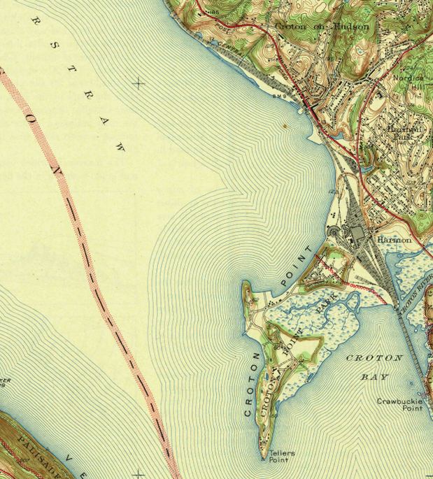
crotonhistory.org — https://crotonhistory.org/2013/06/13/u-s-geographical-survey-map-1943/
…Geographical Survey Map, 1943
This article examines a 1943 topographic map of the Haverstraw Quadrangle, surveyed in 1938 by the U.S. Department of the Interior Geological Survey. The map reveals Croton's landscape before Route 9 construction.
Key observations…
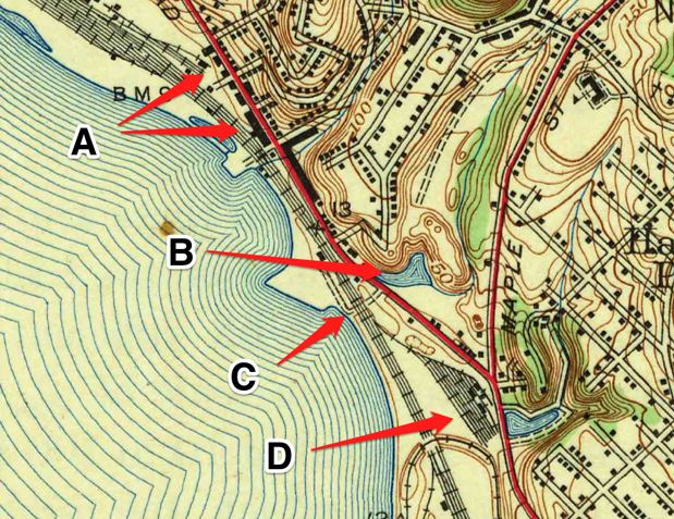
crotonhistory.org — https://crotonhistory.org/2013/06/13/u-s-geographical-survey-map-1943/
…Geographical Survey Map, 1943
This article examines a 1943 topographic map of the Haverstraw Quadrangle, surveyed in 1938 by the U.S. Department of the Interior Geological Survey. The map reveals Croton's landscape before Route 9 construction.
Key observations…
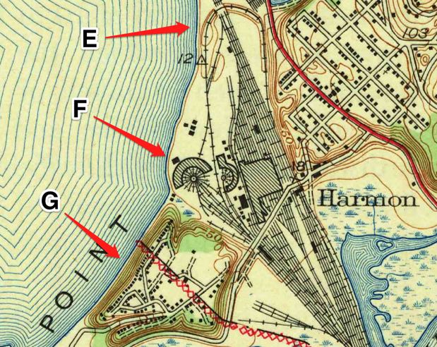
crotonhistory.org — https://crotonhistory.org/2013/06/13/u-s-geographical-survey-map-1943/
…Geographical Survey Map, 1943
This article examines a 1943 topographic map of the Haverstraw Quadrangle, surveyed in 1938 by the U.S. Department of the Interior Geological Survey. The map reveals Croton's landscape before Route 9 construction.
Key observations…