Croton-on-Hudson, NY · Sunday, October 18, 2026· Oct 18, 2026Independent, AI-assisted local reporting from public recordsSource-linked·Corrections welcomed
Overlay a source map, then adjust its opacity. Edges blend into the modern map; small sheets fade as you zoom out.
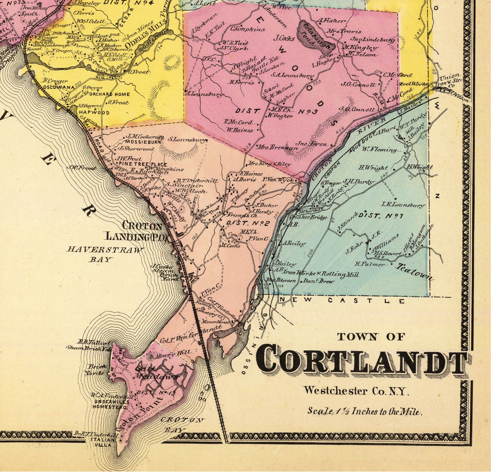
1920 / 1922 · Parker’s Native sites
Northern Westchester · regional reconstruction
Original numbered symbols from Plate 231. Parker called the inventory preliminary. Locations can be hundreds of metres off; this is a historical source to compare, not a surveyed site layer.
Source & alignment
Four locality controls; fit residual about 210 m. A separate Ossining check differs by about 520 m. Only the northern county is fitted; the full original is linked.
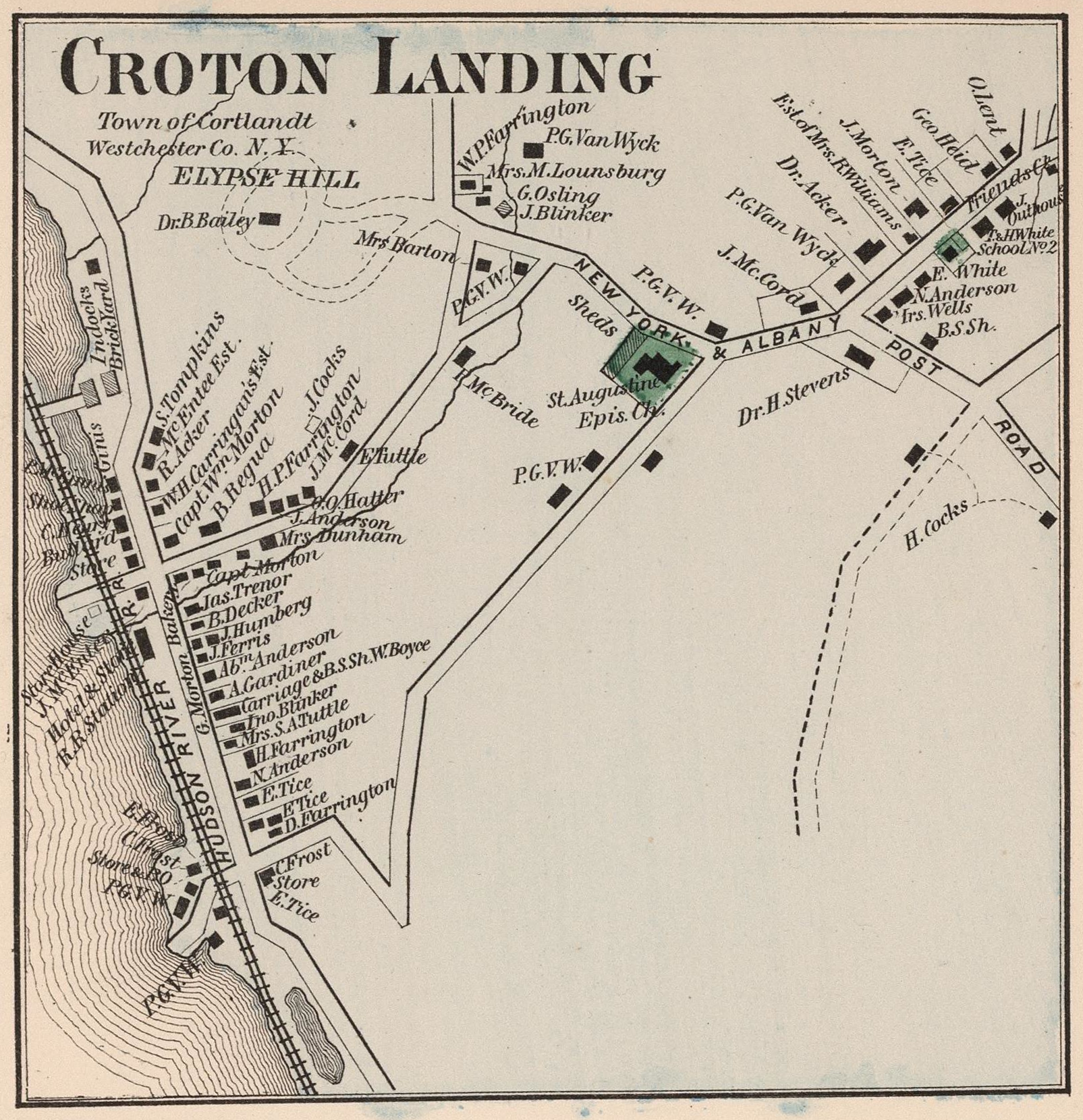
Houses, owners, the railway, brook and older riverbank. Fade it against today’s streets to compare the village before the waterfront highway and later fill.
Source & alignment
Four road-junction controls. A separate St. Augustine’s reference differs by about 23 m. Historical surveying and later road changes remain visible; this is not a parcel survey.
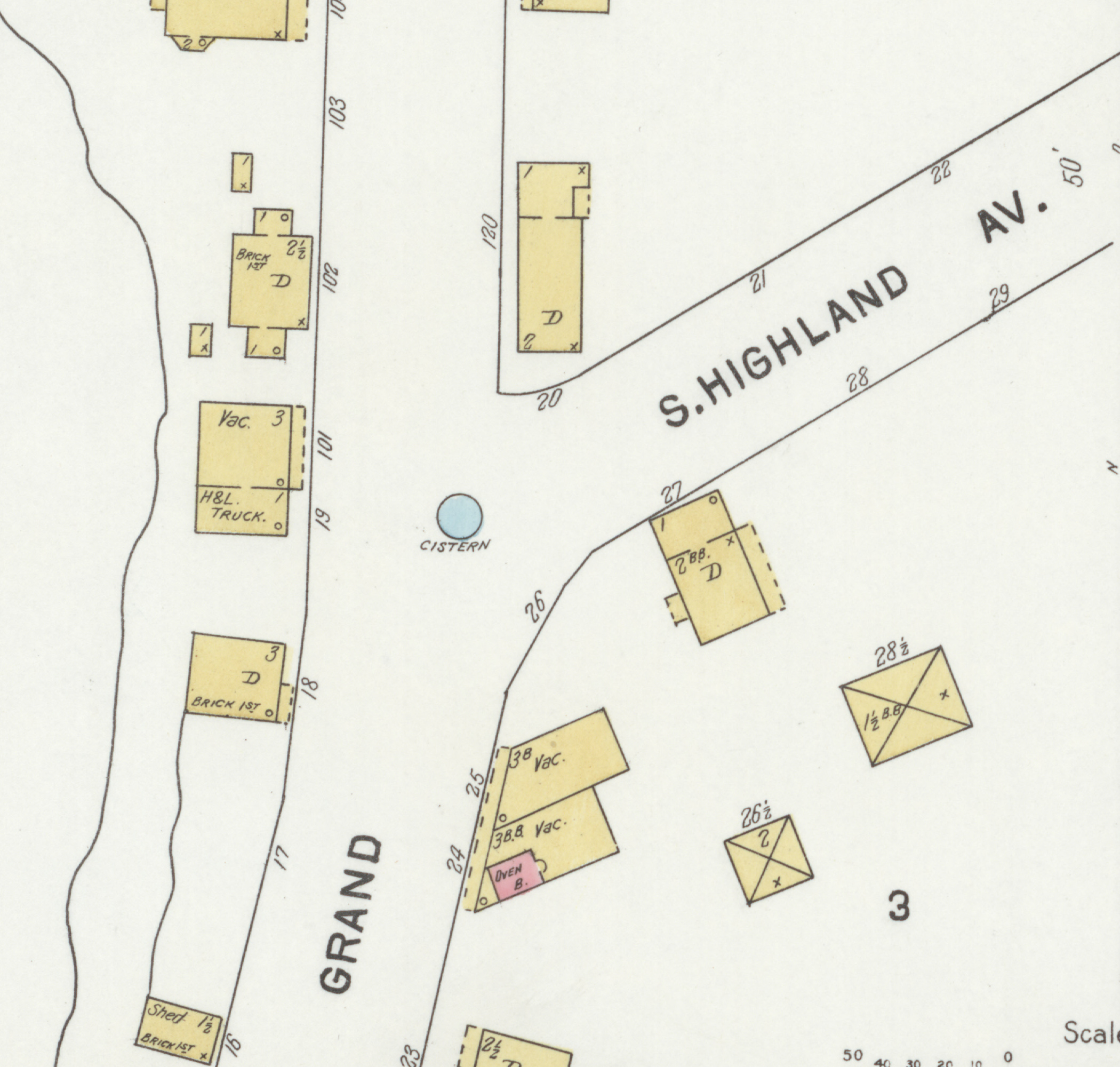
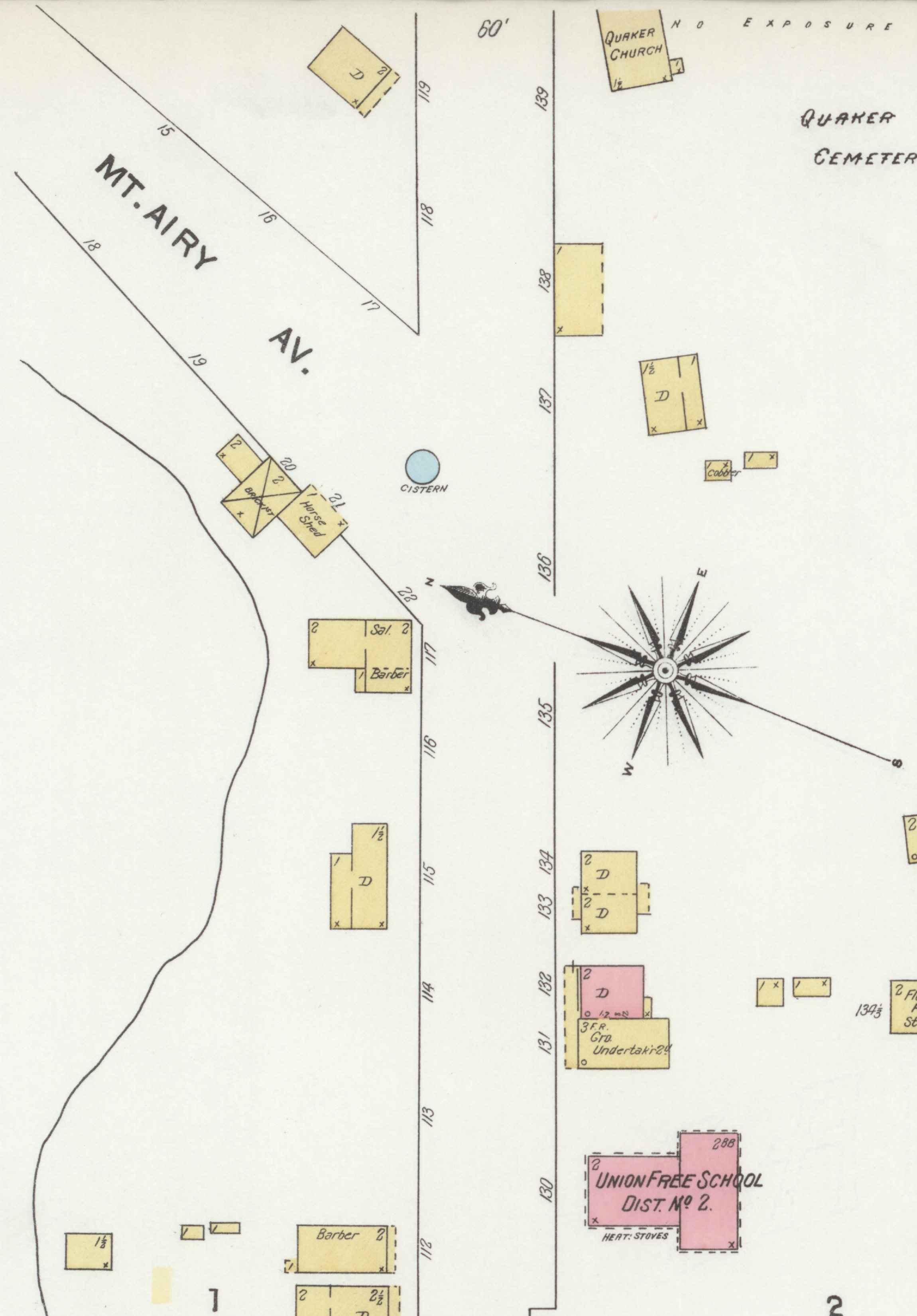
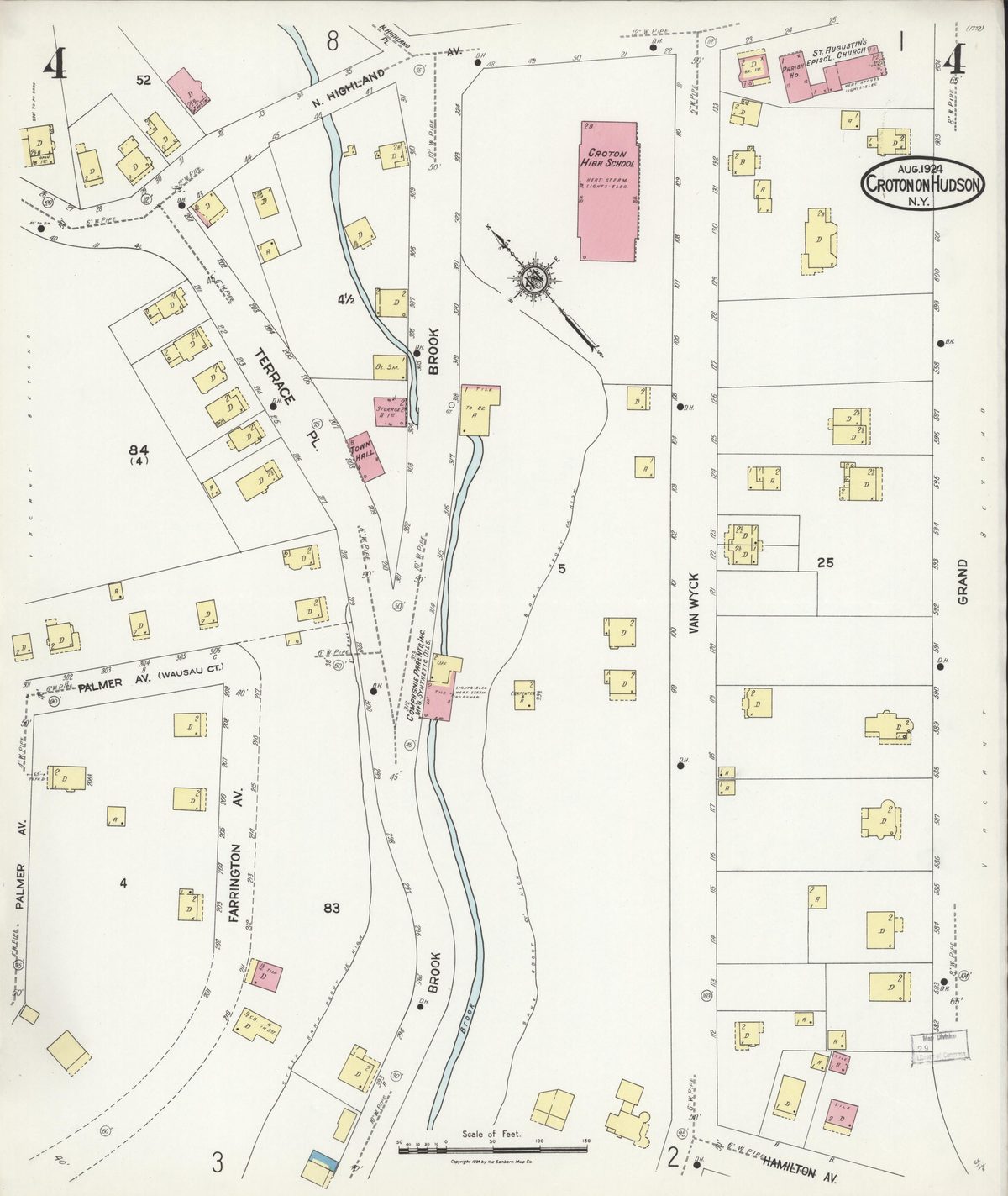
Building footprints, the school, church, brook and water pipes. The sheet shows the brook before later enclosure and records individual structures in the upper village.
Source & alignment
Four building/street controls. Separate church and Grand Street checks differ by about 18 m and 22 m. Symbol placement, surveying and later alterations limit alignment.
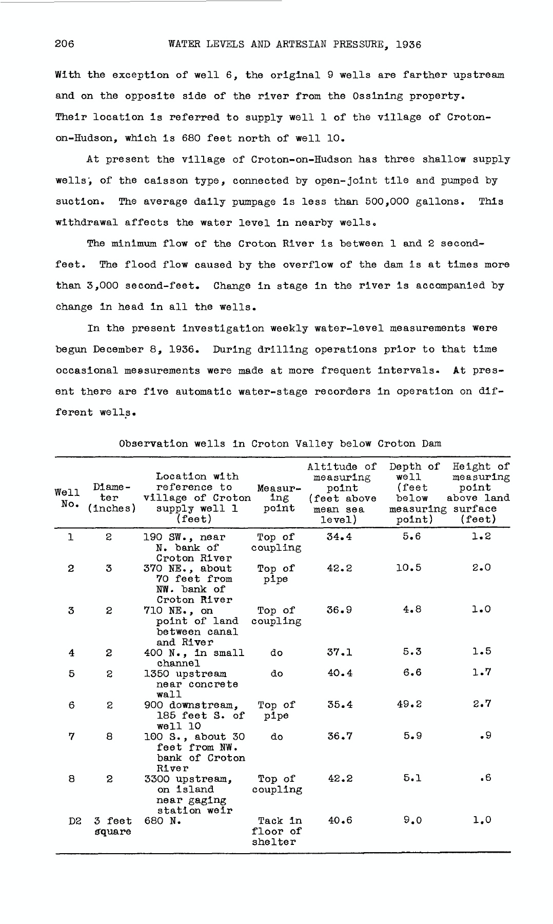
The original geological map distinguishes valley sand and gravel, silt and clay, till and exposed rock. It helps explain the setting of the Croton River aquifer. Geology was mapped in 1986 and published in 1988; the original full sheet includes the legend and underground sections.
Source & alignment
Approximate registration to four printed graticule corners. The horizontal datum has not been verified or separately transformed. A broad Temple Israel comparison differs by about 46 m; it is not a surveyed checkpoint. Original geological contacts include inferred boundaries. Use this for landscape context, not property lines, exact well positions or current water conditions.
Richard J. Reynolds · USGS / NYSDEC · 1982 NYS DOT base
Gouveia & adjoining roads · county aerial composite
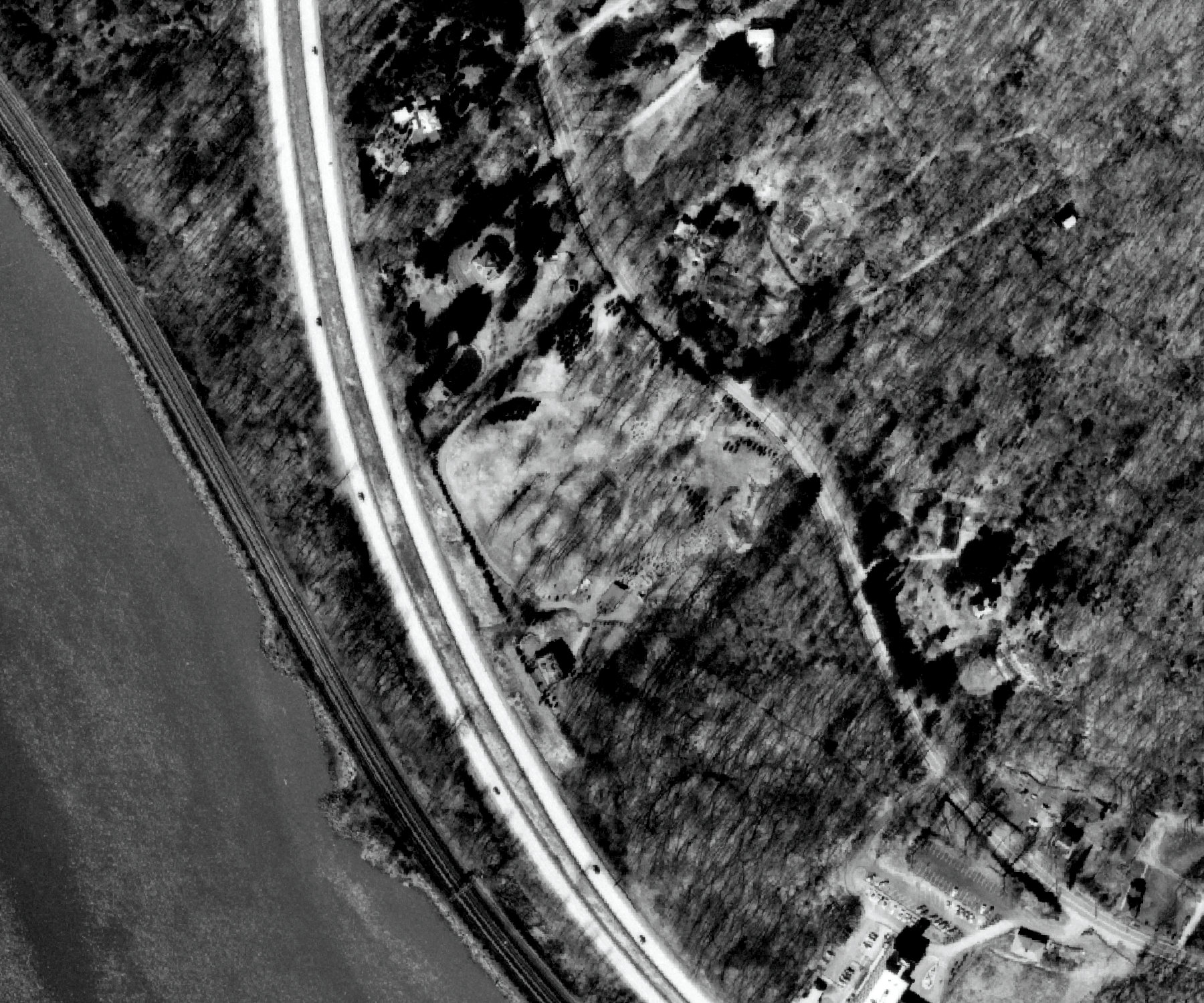
Before the Jurka house’s permit and occupancy records. Local excerpt from Westchester County’s historical aerial composite. The year belongs to the photography, not the park’s acquisition.
Source & alignment
Uses the county service’s EPSG:3857 image extent without an additional manual warp. Historical image distortion and roof displacement remain; no surveyed positional accuracy or legal boundaries are claimed. The small coverage fades at wider zooms.
American Air Surveys, Inc. / Westchester County GIS
Gouveia & adjoining roads · county aerial composite
The house and grounds before Gouveia ownership. Local excerpt from Westchester County’s historical aerial composite. The year belongs to the photography, not the park’s acquisition.
Source & alignment
Uses the county service’s EPSG:3857 image extent without an additional manual warp. Historical image distortion and roof displacement remain; no surveyed positional accuracy or legal boundaries are claimed. The small coverage fades at wider zooms.
Aerial Data Reduction Assoc., Inc. / Westchester County GIS
Brown dashes join towns named by Bolton in 1922; they do not trace a surveyed footpath. Blue dots identify the Hudson waterway, not a recorded itinerary.
The spring, pumps, hillside tanks and fountains make sense as parts of a supply network. One plausible arrangement lifted brook water to hillside storage before distribution to houses and gardens. A railroad main provided another possible source of water and pressure.
Why pump uphill?
Modern ground elevations at the approximate sites, rounded to feet above sea level. Some locations are estimated within broad 100-metre areas, so these heights are approximate too. They are not historic tank levels.
About 110 feet of rise separates the brook pump and track reservoir. The Powers house is lower than the track tank, consistent with gravity flow along the connection described in the later field account. USGS elevation source ↗
The supply network
An original map labels a two-inch tap in the railroad’s eight-inch main. A January 1901 railroad plan also proposes acquiring brook-side land including a reservoir. These records place estate waterworks within a larger railway supply landscape.
The 2018 field account connects the track reservoir to the Powers house, and the reservoir beneath the gazebo to the main dwelling. It describes a brook-side pump sending water uphill. The receiving tanks and intervening pipes still need an original plan.
Storage, gardens and later use
The lower fountain appears assembled in photographs attributed to 1911. The house-side tank doubled as the base of a gazebo. The terrain supports downhill supply to the fountains, while the pump near the grand fountain could have provided local lift or circulation.
The proposed links on the map are a working reconstruction. A pressurized railroad branch could have supplemented or replaced local pumping; different arrangements may have operated at different times. The 1965–1969 spring survey records the surviving complex, not whether the old system was still running.
The 1923 New York Walk Book places Salt Hill north of Colabaugh Pond beside the reservoir. It describes much of the hill and neighboring lands as belonging to Valeria Home. Later, according to DEC, John R. Nelson operated a sawmill here through the mid-1940s; emery mining also took place, although its dates and exact workings remain unlocated.
The map marks the surviving tower, waterworks and structure locations that can be read from DEC’s infrastructure inventory. It leaves unnamed structures unnamed.
Blue Lake and public ownership
State acquisition in 2002 initially anticipated a transfer to New York City’s DEP. In fall 2021 the agencies agreed that DEC would retain the property. The plan’s proposals for removals, trails and parking are not evidence that those works have been completed.
Foundations, wells and a water tower invite a closer reconstruction of life around Blue Lake. A two-acre private inholding and access right of way are recorded in the management plan; this historical map is not an access guide.
Circles mark approximate localities, not territorial boundaries or excavation coordinates. Archaeological sites, names in deeds and reported villages retain their separate source descriptions.
The State Museum chapter describes a fortified settlement on the neck of Croton Point. Its maps locate the enclosure and compare the 1899 plan with surviving features recorded in 2002. The outline on the 1782 French basemap is a later county annotation.
The evidence
Harrington investigated the earthwork in 1899. The published comparison with observations in 2002 is evidence of a particular enclosure, rather than proof that all occupation on the peninsula belonged to one village.
A name can cover more than a site
Grumet’s 2014 gazetteer questions the familiar equation of the name Kitchawan with the Croton River, discussing a deed that may instead refer to Sing Sing Creek. The fort’s published site label is retained without treating that wider name history as settled.
Location. Generalized neck of Croton Point; interpreted from the museum’s Figures 5.1–5.2. The circle is a locality guide, not the enclosure boundary.
Excavations in 1960–1963 examined oyster-shell deposits on the northern shore of the peninsula. The local archaeological chapter reports that erosion has since removed the site. Different shell layers preserve evidence of repeated use of this shore.
What the deposits record
Shell deposits and stone artifacts document food gathering and repeated occupation. Excavation dates are dates of research, not the beginning of Native life here. The shoreline has changed since the work.
What the first radiocarbon result measured
Brennan’s 1963 report describes small charcoal fragments collected throughout the shell deposit in May 1962. He treated the resulting date as an average, not the oldest age, and said the charcoal was no longer in its original depositional position. It cannot supply a precise founding date.
Location. Generalized northern promontory of Croton Point, using the excavators’ locality description. It does not mark a surviving excavation.
The Lower Hudson Chapter excavated Piping Rock from 1972 to 1980. It places the site at the mouth of the Croton River in northern Ossining. Its findings are a separate archaeological record from the settlements and middens on Croton Point.
Reading the dates
The excavators distinguish finds associated with occupation layers from older tool forms found without the same context. This atlas does not turn a tool’s typological age into an exact date for a village.
Dating objects in context
The 1974 excavation discussion describes triangular points in two dated shell deposits. Brennan cautioned against assigning an age from point shape alone. These historical shell measurements require appropriate calibration and reservoir corrections before they can be expressed as calendar dates.
Location. Generalized Ossining side of the river mouth. The published chapter history does not provide a surveyed excavation boundary.
An island excursion, advertised in 1888The New York Age advertisement offers 50-cent return tickets aboard Sirius for August 15. Open the original newspaper page.Archaeological locality
Oscawana Island combines an Indigenous shell-deposit record with a railway and excursion history. An 1851 guide describes its rock tunnel; 1880s newspapers record groups arriving for outings. Brennan’s later excavation and the town’s boat-launch records document different uses of the same island.
Earlier inventory
Parker’s number 5 also reports a small village on the island and camps along the shore. That early classification and Brennan’s later shell-midden discussion are kept as separate descriptions of evidence.
A name in the railway record
An 1851 railway guide calls the place Oscawana, or Peg’s Island, while describing a 225-foot tunnel. This establishes the name in nineteenth-century print; it does not establish an Indigenous village’s original name.
Island and estate
The racetrack, cow barn and house foundations lie east of Cortlandt Street in the former Long View estate. Use the Oscawana area view to see these later landmarks alongside the island.
Excursion destination
The New York Age reported a Zion Church outing in July 1888 and advertised a separate lodge excursion aboard Sirius for August 15. The advertised round trip cost 50 cents and promised two bands. The report and advertisement establish activity and promotion, not a complete resort plan.
What the excavation can tell us
Brennan’s 1963 account describes excavation of an oyster-shell deposit in 1962. Erosion had disturbed the sequence of deposits, limiting chronological conclusions. The report supplies no island-specific radiocarbon date.
County history places Oscawana Island within the Cruger estate
In its description of Boscobel and the Cruger family, Bolton’s 1848 county history says Oscawana Island formed part of the Cruger estate. This is a published ownership account, not an inspected conveyance or a date for the beginning of ownership.
Location. Island locality identified on the USGS map; circle covers a general area rather than an excavation position.
These are dates of documents, reported activities and research. They do not establish when Indigenous occupation began or settle the island’s complete ownership history.
Brennan distinguishes the Wolcott and Dogan localities at Montrose Point. His discussion compares their shell layers with Croton Point and other Hudson sites. They should not be collapsed into one settlement or one date.
Location. Generalized Montrose Point locality from the USGS map. This broad circle does not locate either excavation.
Artillery sent by Colonel James Livingston fired on HMS Vulture from the point. The ship moved downstream. Contemporary records support that cannonade; the claim that Peterson and Sherwood initiated it rests on later, disputed accounts. The linked article examines those accounts separately.
Location. Southern end of Croton Point, identified on the historical USGS sheets; the exact battery position is not established here.
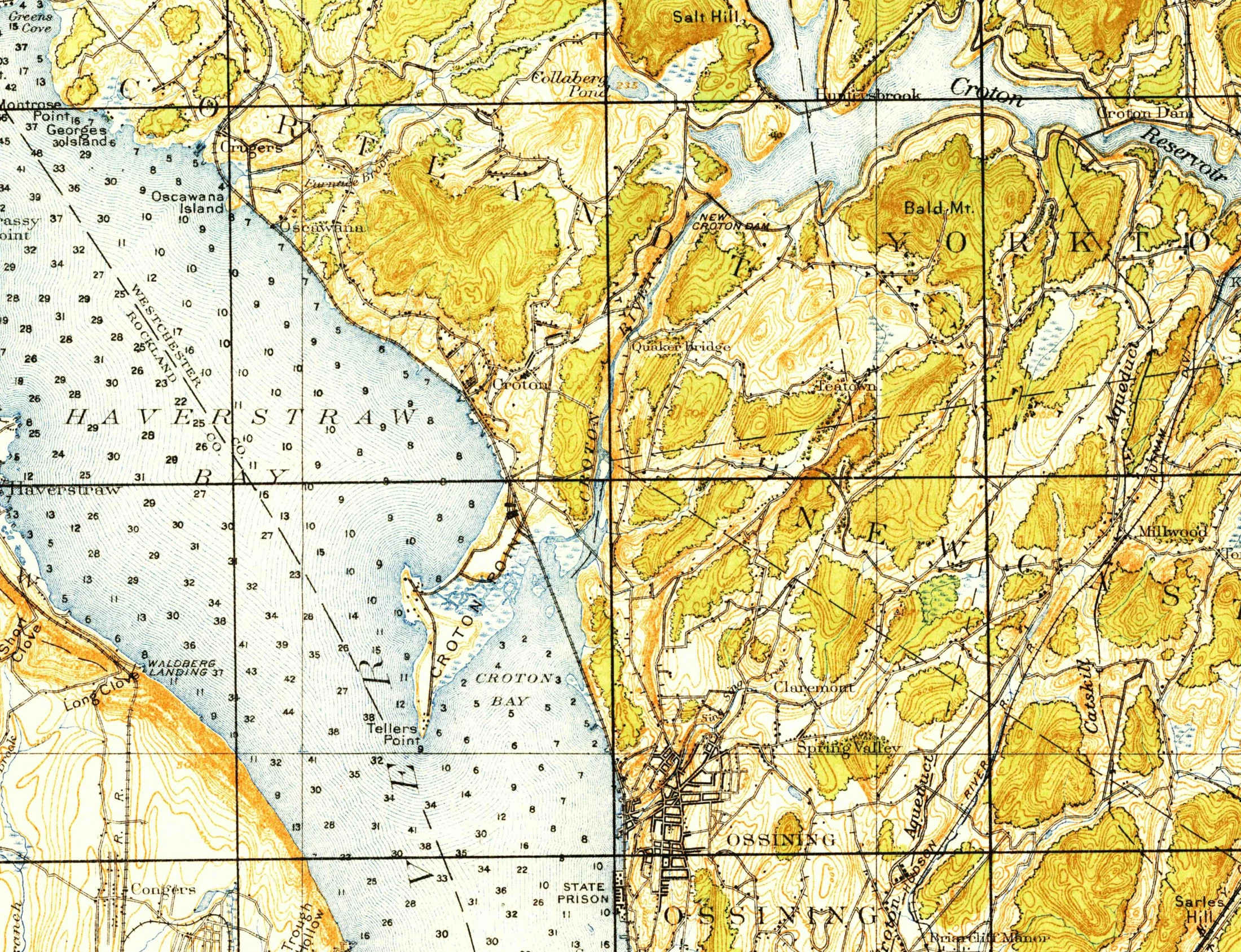
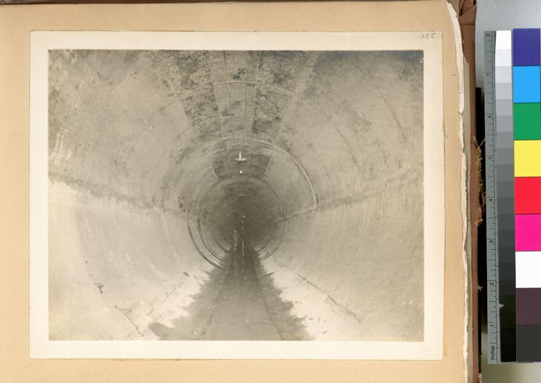
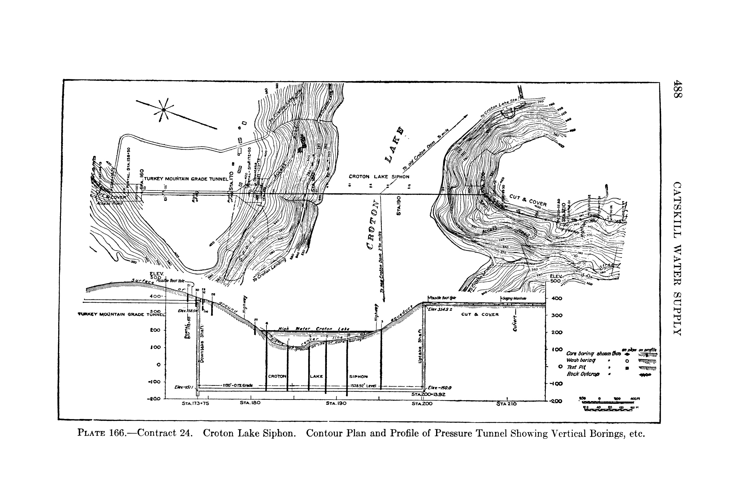
The original dam supplied the Old Croton Aqueduct. Compare the small reservoir and river valley on the 1892 map with the much larger reservoir in 1937. The new impoundment submerged the old dam.
Survey, construction, failure and first water
King’s 1843 Memoir separates the 1835 lake-land survey, the 1837 contracting stage, the January 1841 loss of the earthen embankment, and the masonry replacement reported in January 1842. A secondary timber-and-stone dam about 300 feet downstream protected the apron and supported a bridge. That work belongs to this submerged dam complex; it is not identified with either lower-river weir. Water was admitted to the aqueduct here on June 22, 1842.
Location. Approximate submerged dam locality read from the dam symbol on the georeferenced 1892 USGS sheet. Nearby landmark comparisons differ by about 18–22 m; historical map registration and manual reading do not establish the precise submerged footprint.
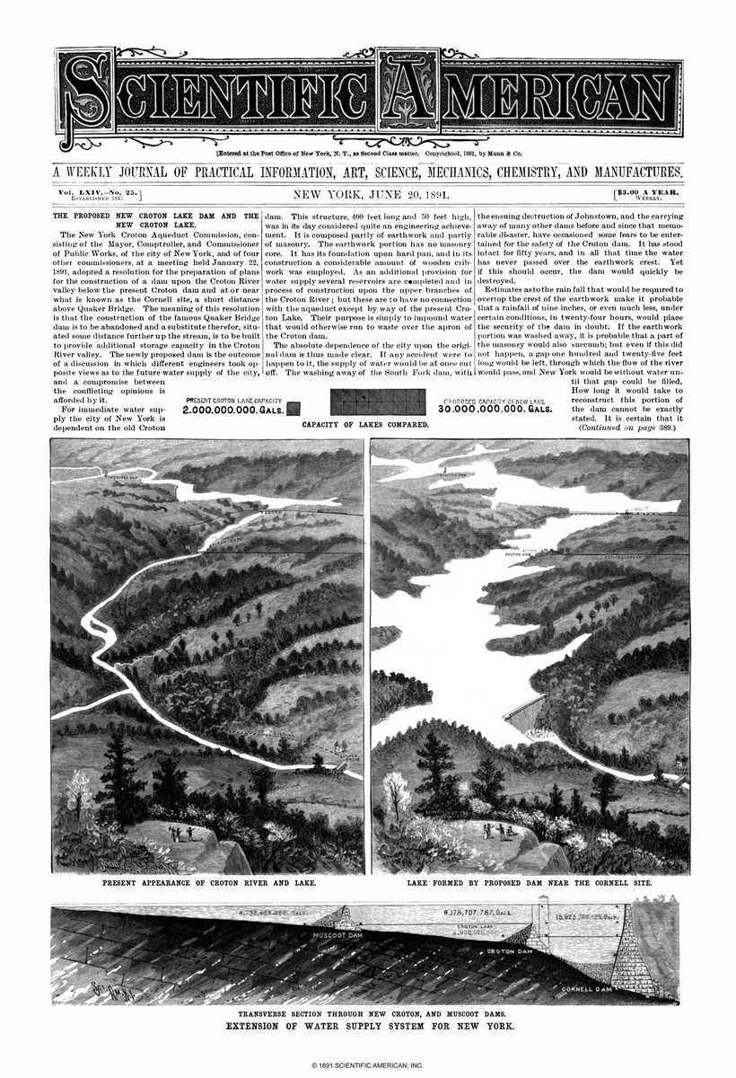
Proposed New Croton Lake Dam — complete Scientific American cover, June 20, 1891Scientific American, June 20, 1891, p. 383: complete cover with a contemporary valley engraving, an imagined reservoir view and a proposed dam section. The continuation on p. 389 explicitly says vertical measurements in the section are exaggerated. These are illustrations of a proposal, not photographs or an as-built survey. Munn & Co.; scan from Survivor Library. Research lead: Croton History / Marc Cheshire, “Croton River Valley, Before & After.”
Historic images
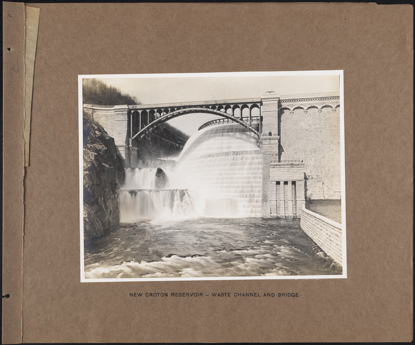
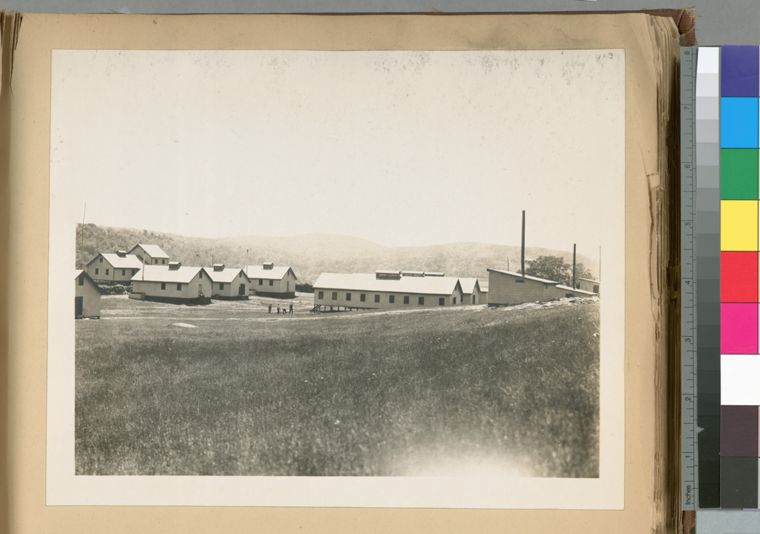
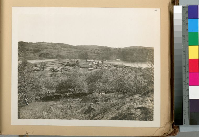
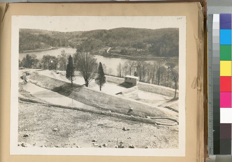
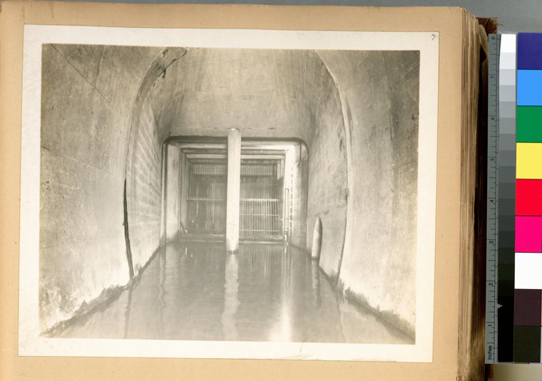
Spillway and bridge in the museum albumca. 1905 — museum attributionPhotographer unknown. Museum of the City of New York, 42.172.95. Complete mounted album image; date approximate and camera position unlocated. Source gallery ↗
The enlarged reservoir transformed the valley upstream. Switch between 1892 and 1937 here to see the change in the water’s extent. The dam, spillway and aqueduct works form different parts of the water-supply system.
A proposal shown before construction
The June 20, 1891 Scientific American cover pairs the then-present river valley with an imagined lake behind a proposed Cornell-site dam. Its account reports a January 22 vote to prepare Cornell-site plans in place of the Quaker Bridge proposal. The continuation explicitly says that its dam section exaggerates vertical measurements. Croton History / Marc Cheshire identified these engravings in “Croton River Valley, Before & After.”
A museum album view of the spillway
The Museum of the City of New York identifies a mounted album photograph of the New Croton Reservoir waste channel and bridge as circa 1905, with the photographer unknown. This is a museum-attributed approximate date; it does not identify an exact exposure day.
Location. Dam locality identified on the USGS sheet and present-day map; marker represents the structure as a whole.
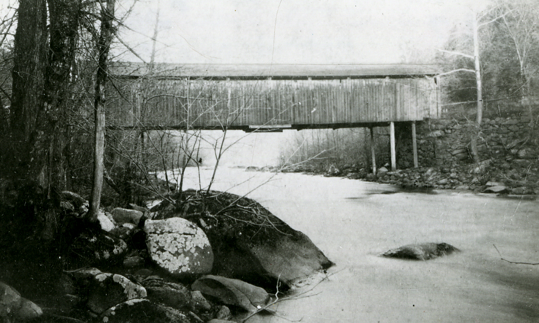
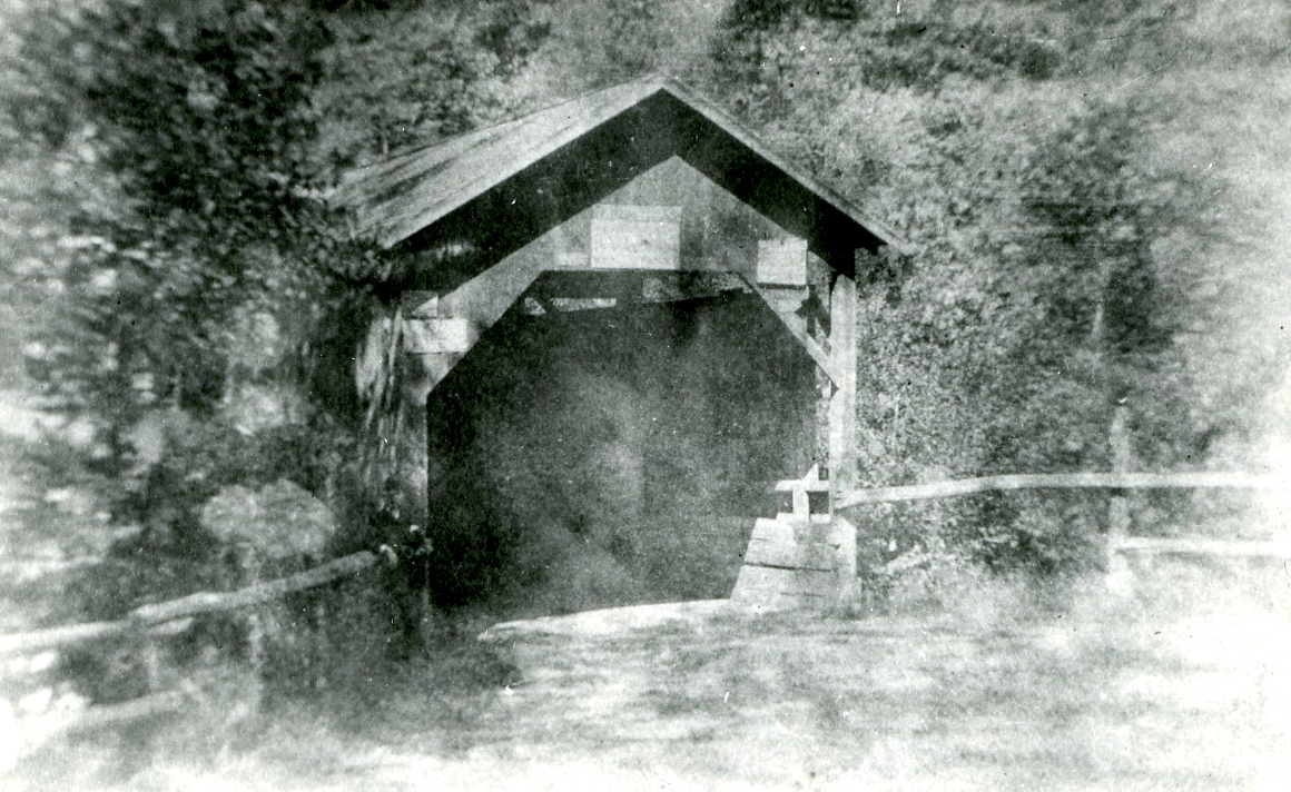
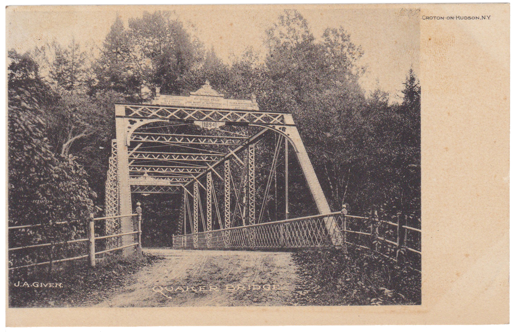
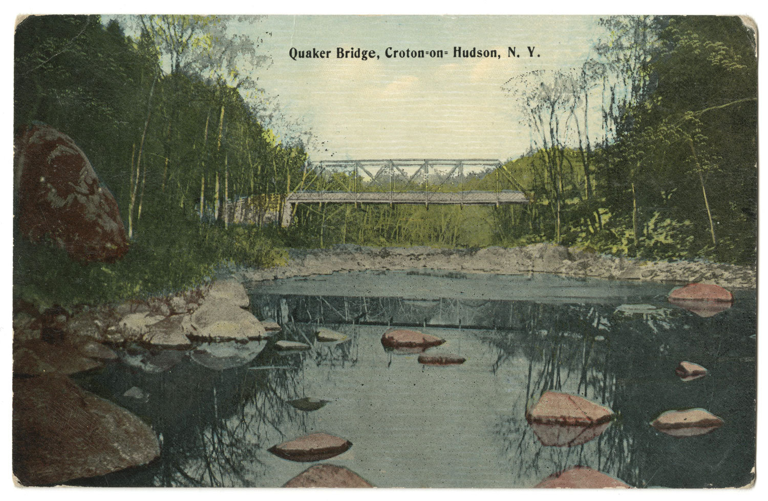
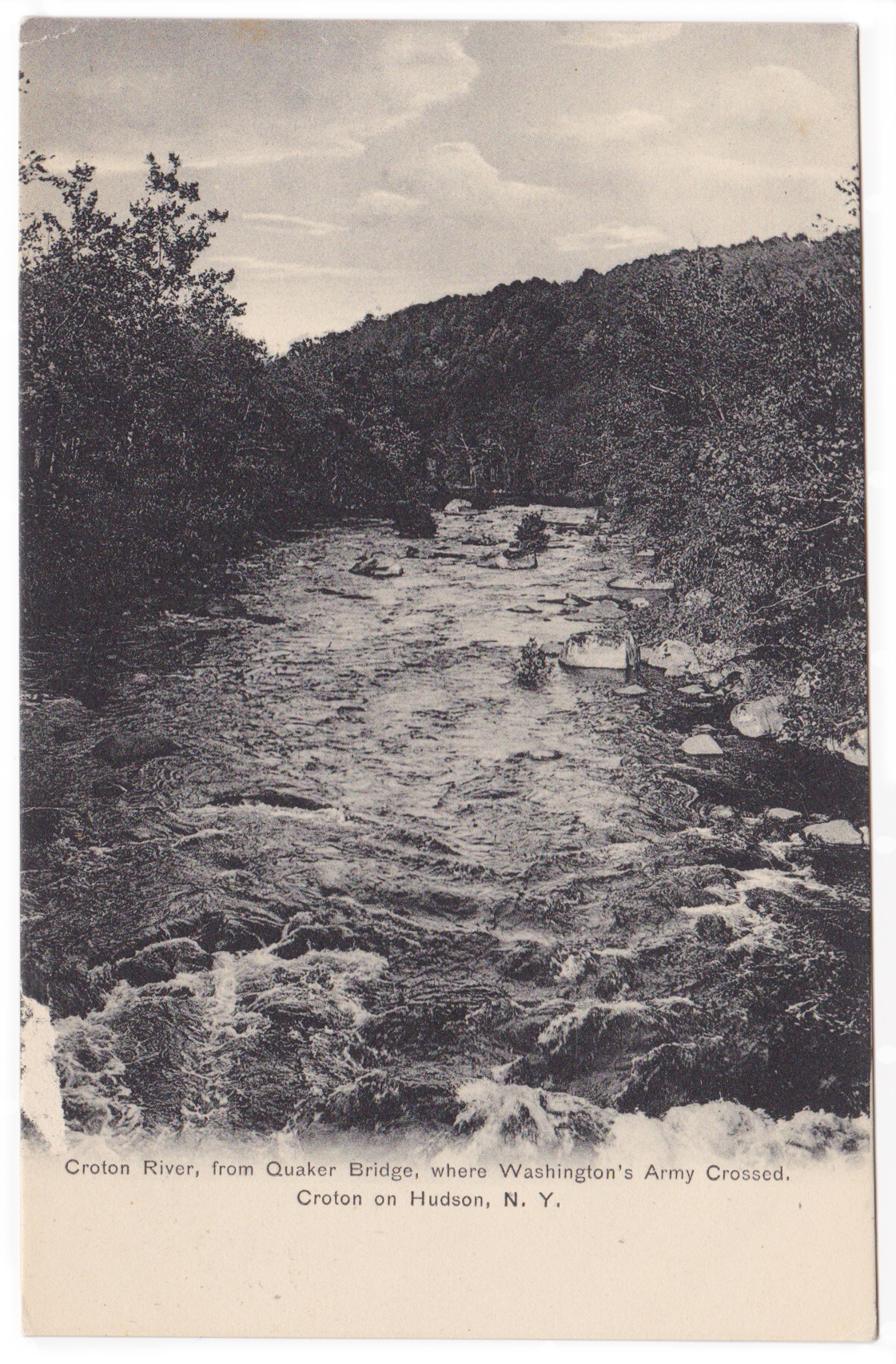
Covered Quaker Bridge, side viewBetween 1847 and 1894 · exact exposure date unknownWestchester County Historical Society photograph, reproduced by Croton History. The wooden covered crossing preceded the 1894 iron bridge. Source gallery ↗Covered Quaker Bridge, portal viewBetween 1847 and 1894 · exact exposure date unknownA second view of the covered bridge. Westchester County Historical Society, via Croton History. Source gallery ↗Quaker Bridge, J. A. Given postcardCirca 1901–1907 · later catalog attributionJ. A. Given postcard, printed by the Albertype Company, Brooklyn. Reproduced and identified by Croton History. Source gallery ↗Quaker Bridge, Frank L. Simone postcardPostmarked 28 July 1914 · exposure date unknownPublished by Frank L. Simone; Croton History records the Oscawana postmark. Postmark date is not the photograph’s exposure date. Source gallery ↗Croton River viewed from Quaker BridgeCirca 1901–1907 · later catalog attributionPublished by William Terhune, printed in Germany, reproduced by Croton History. Its Revolutionary War crossing caption is an attributed postcard claim. Source gallery ↗
This crossing has carried several bridges. The county’s engineering history traces an 1809 turnpike crossing, William Purdy’s 1830 rebuilding, the loss in the 1841 flood and an 1847 covered replacement. Dean & Westbrook built the iron Pratt truss in 1894 with Phoenix Iron Works components. Its later fabric reflected repeated repairs rather than one untouched structure. The village reports that the 1894 span was demolished during the week of July 20, 2026, for replacement.
A bridge repaired across generations
The engineering record documents 1938 decking and ironwork repairs, framing work dated 1951, a 1977 deck-and-rail scheme, replacement stringers and steel-grid deck in 1994, and rehabilitation in 2009. Its original 1894 construction drawings were unlocated when that report was prepared.
Postcards and the crossing they claim
Croton History identifies the covered-bridge photographs as Westchester County Historical Society images and records the publishers of later postcards. The river-view card’s claim that Washington’s army crossed here does not establish that the Revolutionary War’s “New Bridge” occupied this exact site. The proposed nineteenth-century Quaker Bridge Dam was a separate project that was never built here.
Authority for historic-preservation measures in 2025
On August 14, 2025, the County Board of Acquisition and Contract authorized entry into Agreement 25-922 with the U.S. Army Corps of Engineers, New York District, and New York State Historic Preservation Office for the Quaker Bridge replacement. The approved resolution calls for HAER Level II documentation, historic-preservation review of drawings, an offer of historic plaques and portal corner members to the Town and/or Village, and a post-work report. These are authorized commitments: this record does not establish execution of the agreement, completed documentation, or acceptance of salvaged material. The five-year term runs from execution, whose date is not established by the authorization. The action log records approval; the posted minutes retain a Draft header.
Plaques stored during replacement
The Village's project page, captured on October 17, 2026, reports that the contractor removed the bridge's commemorative plaques and that they were being stored for safekeeping. It also describes Village, Town and County cooperation to preserve elements for a future memorial. The page gives no removal date, storage location or named custodian. It does not document receipt of the portal corner members, transfer of the plaques to either municipality, or a completed memorial.
The 1841 flood: sequence and cause
The Water Commissioners’ contemporary report, reproduced by King in 1843, says Tompkins’ Bridge had gone before the dam failed. They believed Quaker Bridge and Wire Mill Bridge had also gone first. Their account corrects the implication that dam failure is established as the cause of Quaker Bridge’s loss.
Location. Generalized crossing locality, using the former span's mapped endpoints as a reference. The historic span was removed in 2026; no engineering footprint is implied.
The 1809–1847 sequence is reported in the engineering history from the Croton-on-Hudson Historical Society. Later repair descriptions rely on historic contracts, drawings, county proceedings and dated bridge members cited in that report. The point marks a crossing used by successive structures.
Railway on both surveys; electric terminal documented 1913
The surveys show the Hudson shoreline railway and the changing river-mouth landscape. By 1913, the railroad's annual report described development of an Electric Division terminal at Harmon. Compare the shoreline, rail facilities and surrounding development across the two maps, then fade the layer to see today's station and tracks.
Before the electric terminal: the steam railway
Steam trains preceded the electric terminal by more than sixty years. In his March 1850 account, engineer John B. Jervis described the operating New York–Poughkeepsie line and reported passenger receipts beginning in October 1849. He explained how rock and earth cut from projecting riverbanks were used to fill the intervening bays, and how soft foundations caused embankments and river walls to sink during construction. This is his account of the shoreline railway as a whole; it does not identify the construction date of a particular Harmon station building.
Building the electric terminal
The railroad’s 1906 annual report lists Croton station, yard and terminal improvements, four-tracking and electrification expenditures. Its 1912 report describes development of the new Electric Division terminal at Harmon. A March 1913 full-operation date appears as a forecast in a report compiled in 1913; it is not confirmation of an opening day.
Location. Generalized Hudson railway corridor at Harmon, not the footprint of a particular station building. No railway junction up the Croton valley is inferred.
The county acquired Croton Point in 1923. Recreation and waste disposal subsequently occupied different parts of the peninsula at the same time. The park did not begin with the landfill’s closure.
Three generations of vineyardists and a grape breeder
The New York agricultural station’s 1908 grape volume distinguishes the family vineyardists from Stephen W. Underhill, William A. Underhill’s son, who bred new varieties at Croton Point. It reports that he planted the Croton grape seed in spring 1863 and first obtained fruit in 1865. Its Senasqua entry separately records seed planted in 1863 and introduction about 1870; it does not give Senasqua a first-fruiting date of 1865.
Location. Representative point within the park. Circle is not the park’s property boundary.
The 2019 periodic review dates operation of the original unlined landfill from 1927 to 1986. Other disposal areas had separate operating periods. The capped land remains part of a managed environmental site.
Location. Generalized central disposal area; this map does not delineate individual landfill cells or their engineering boundaries.
A survey of the beach and shallow water recovered 125 stone artifacts: flakes, cores and tools. Finds from both land and water show why the present shoreline cannot be treated as the limit of the archaeological record.
How it was investigated
The project used 365 underwater test pits and 36 beach shovel tests, alongside surface collection. Most of the recovered objects were flakes from stone working. One diagnostic projectile point helps interpret the material; it does not date every find.
Location. Generalized southeastern shore at the peninsula’s waist, interpreted from Merwin’s Figure 28. Individual test units and artifact positions are not plotted.
Brennan describes a shell-bearing site on a bluff between Croton Point and Montrose Point, destroyed by road building. He compares its layers with other Hudson sites. The report preserves evidence from a place whose deposits could no longer be revisited.
An earlier excavation account
The 1962 report describes separate shell deposits and contrasting tools. Its proposed chronology depended on a contemporary sea-level model and comparisons with other places, rather than a directly dated Parham sample. The layers are evidence; their proposed calendar ages remain an interpretation.
The excavation years
Brennan’s November 1963 report says he and his colleagues dug Parham Ridge in 1959 and 1960 (printed p.16). A March 1962 account already described its separate shell deposits; the 1968 comparison was later reporting. These dates describe investigation and publication, not the beginning of occupation.
Location. Broad shoreline-bluff locality reconstructed from Brennan’s description, not a surveyed site position. The report places it roughly halfway between the two points.
A deed transcribed in the 1881 Westchester history calls the neck Navish and its meadow Senasqua. The distinction matters: these are names for parts of a landscape, not evidence that every Croton Point site was one village.
What survives in the record
The transcription names Native grantors and describes marsh, meadow, creek and marked trees. It records a colonial land transaction. It does not supply a village plan, and the 1881 printed text is a later transcription rather than the original deed.
A date that needs the original deed
Bolton’s 1881 transcription prints 3 June 1682; Grumet’s museum gazetteer gives 23 June. Their citations overlap in Deed Book A, pp. 181–184. The original county record has not been compared here, so the day remains unresolved.
Location. Generalized Croton Point peninsula. No deed boundary has been reconstructed from its named creeks or marked trees.
Ossining takes its name from the Sint Sinck community. Federal and village histories identify the community in the area before European settlement. This marker represents that historical association with Ossining, rather than an excavated village at a modern street address.
Names and affiliations
Colonial spellings and later descriptions vary. A place name does not, by itself, establish an exact settlement footprint or a fixed territorial boundary.
Names in seventeenth-century peace records
Two colonial peace texts name the community. In the agreement dated 22 April 1643, Oratamin is described as representing several communities, including Sintsinck. In the articles dated 30 August 1645, Aepjen is said to speak for Wapping, Wiquaeskecks, Sintsings and Kichtawanghs. These spellings come from B. Fernow’s 1881 translated documentary edition; the original manuscripts have not been examined here. The 1645 text places the proceedings at Fort Amsterdam. Neither record dates the founding of a settlement at Ossining, fixes its boundaries or supplies a complete Indigenous account of the negotiations.
Location. Broad Ossining locality. The cited public histories do not provide an archaeological village boundary.
The 1683 deed transcribed in Bolton’s revised county history names Meahagh and Appamaghpogh. The surrounding narrative identifies Meahagh with Verplanck’s Point. The deed describes land, waters and resources; it is not a map of a village.
A source to read critically
This is a nineteenth-century printed transcription of a colonial deed. Its legal language records a transfer asserted by the document; it does not tell us everything about Native understandings of land use or the lives of the named people.
A separate archaeological report
Parker’s number 6 describes a village site on Banner Brick Company property at Verplanck. This is a different kind of record from the deed’s landscape names; it does not prove that the named tract and the reported village had identical bounds.
Spelling and interpretation
Grumet reports that a State Library manuscript copy reads Meanagh. He proposes a Munsee comparison meaning fence or fort. This is a scholarly reading of the name, not a surveyed fort location or a settled translation.
Location. Generalized Verplanck peninsula, following the place identification in the printed history. The larger tract described in the deed is not drawn.
Bolton’s revised history places Sachus, also written Sackhoes, near the later village of Peekskill. It names Sirham as its chief in 1682. This is a historical report to investigate, not an independently verified excavation location.
Strength of the claim
The village identification here rests on the cited nineteenth-century account. It is displayed separately from the sites supported by excavation reports, so the two kinds of evidence can be compared.
Another early inventory
Parker lists Sachus or Sachois as number 2, near Peekskill and its creek. A later catalogue repeating a historical identification does not by itself establish an independently excavated village footprint.
Location. Broad Peekskill vicinity only. The account supplies no street-level position, and this atlas does not infer one.
Reginald Pelham Bolton describes a Hudson River path that developed into the Albany Post Road. On pages 91–92 he names Dobbs Ferry, Tarrytown, Ossining, Croton and Peekskill as principal stations, continuing through the Highlands at Continental Village.
What the map line means
The atlas connects Ossining, Croton and Peekskill schematically. Bolton’s text establishes this proposed sequence, while the exact local route remains unresolved. His regional Map I is linked in the library catalogue; it has not been traced here.
Which Bolton?
This is Reginald Pelham Bolton’s 1922 work. Robert Bolton’s earlier Westchester history and its later revised edition are separate works, with different claims and source problems.
Location. Interpretive anchor in Croton. The dashed line joins the towns Bolton names; it does not trace a surveyed Native footpath or a verified alignment along today’s streets.
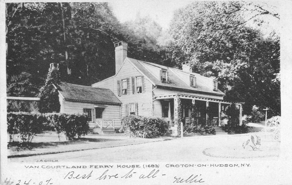
Eighteenth-century country house and ferry crossing
Historic images
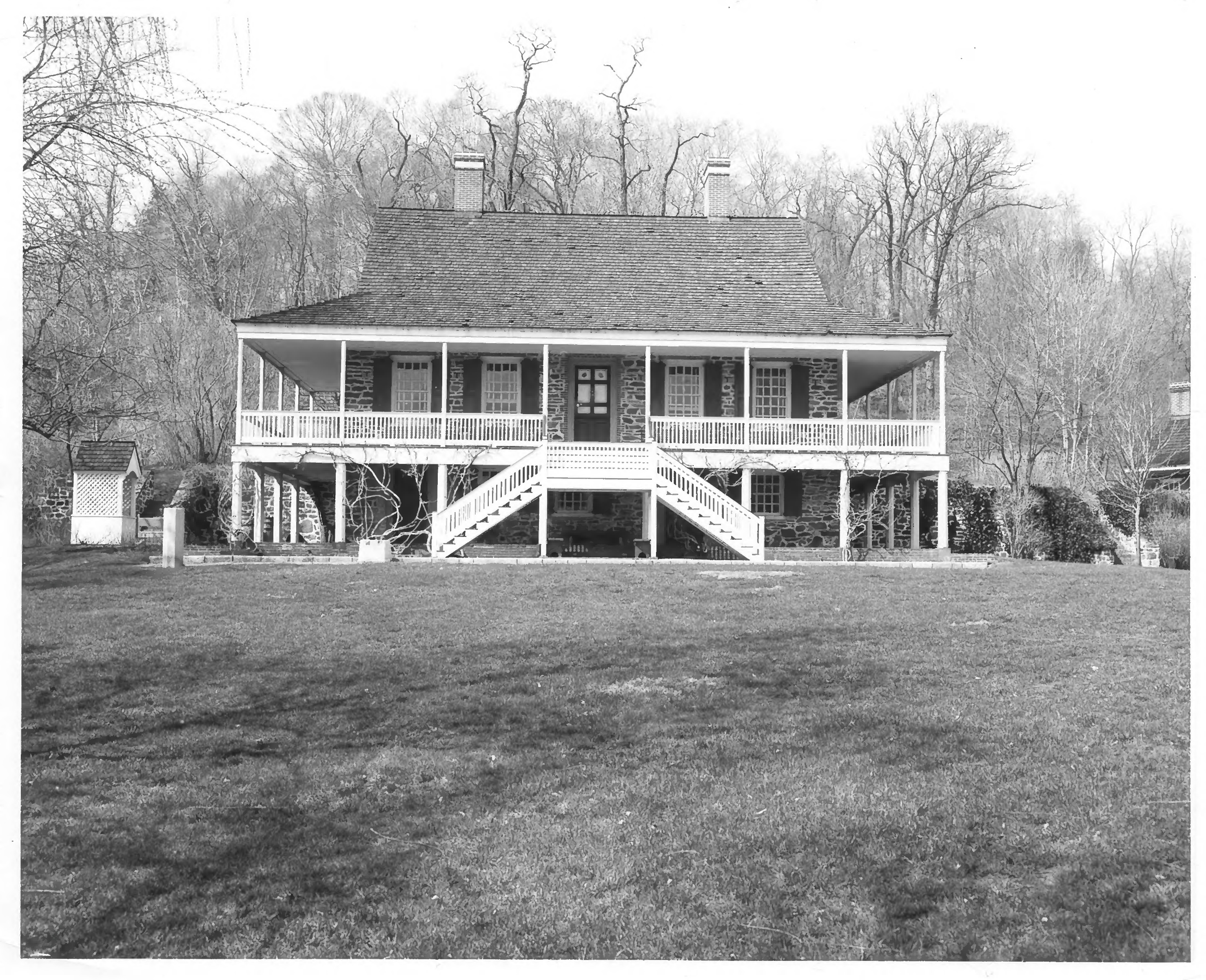
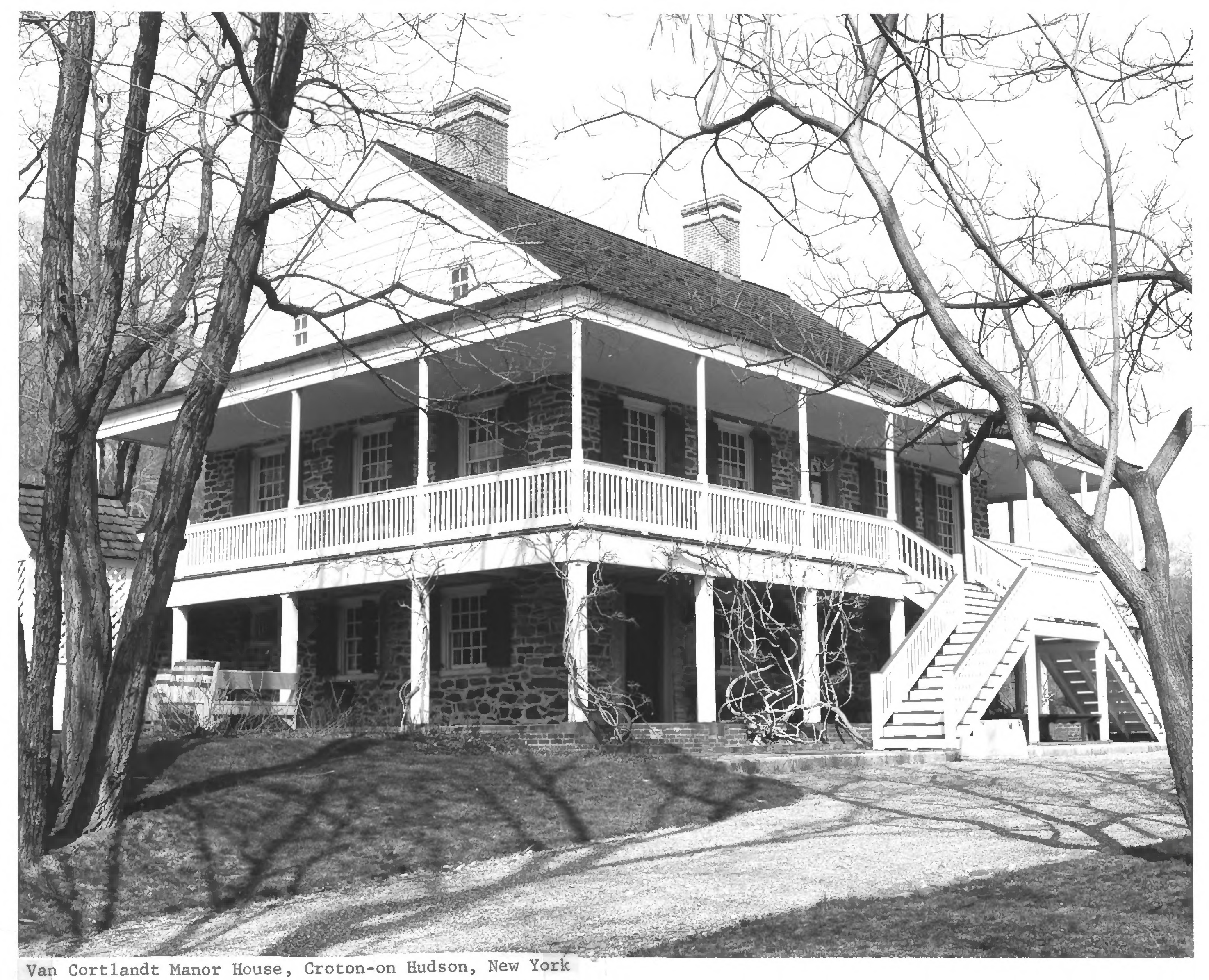
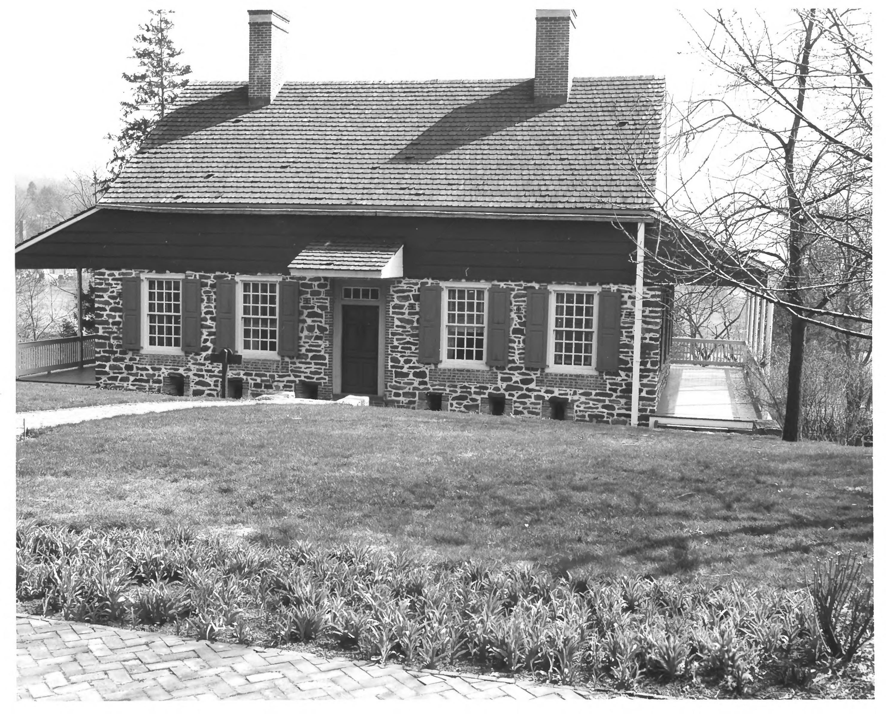
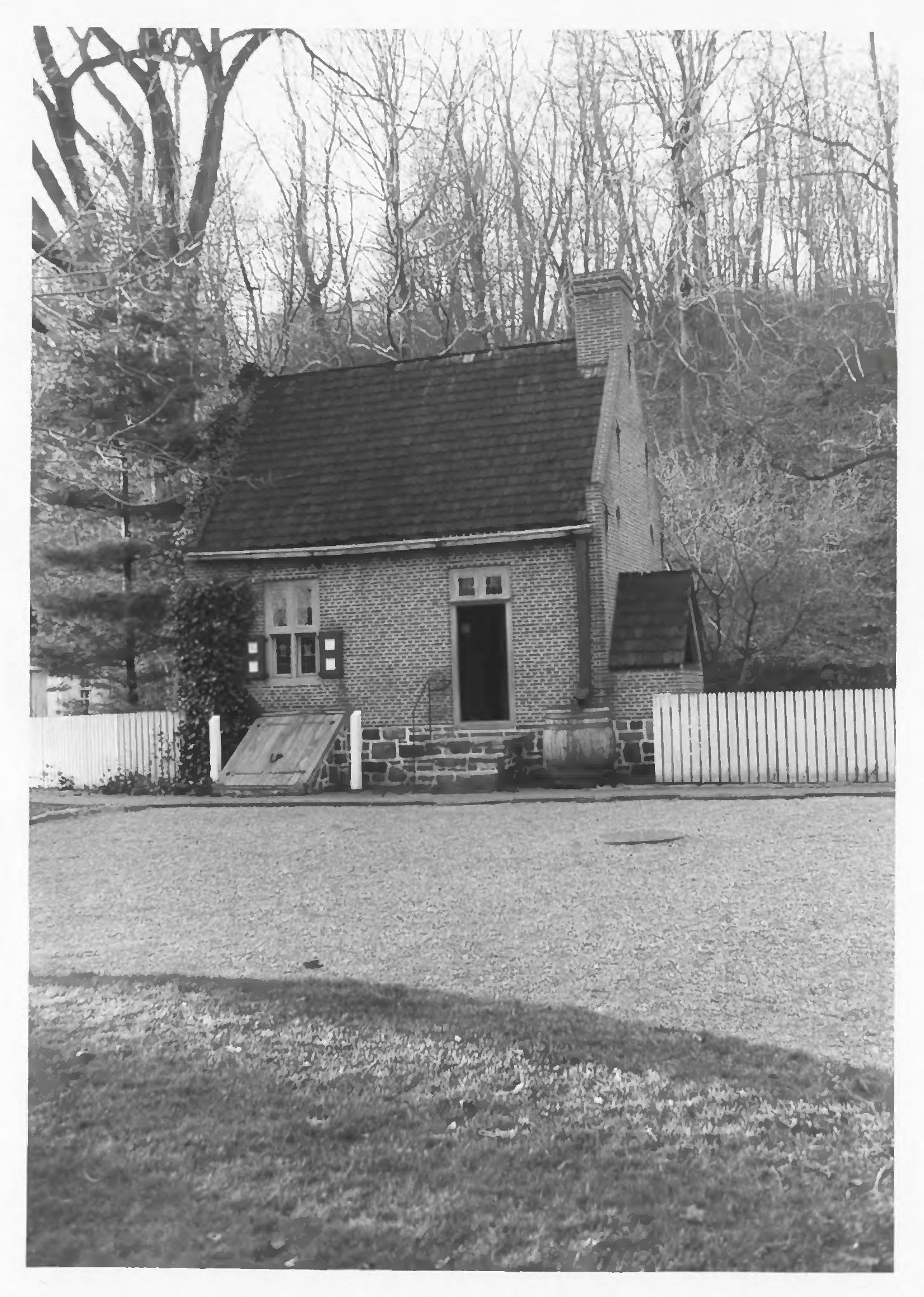
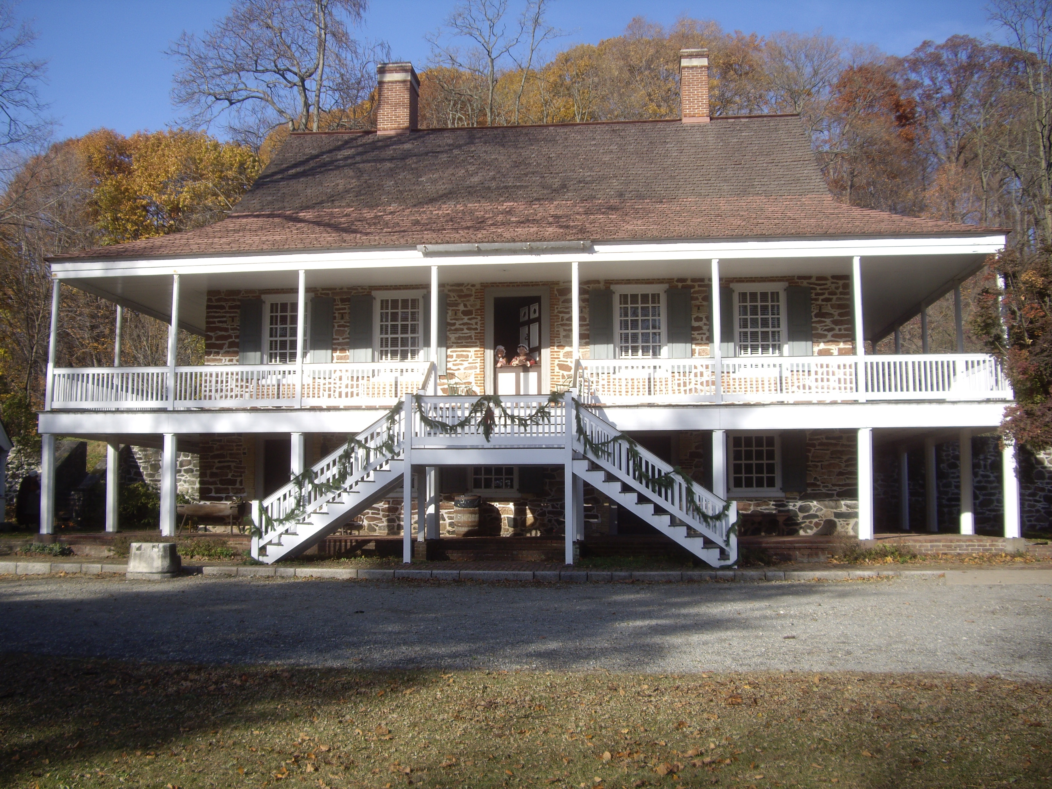
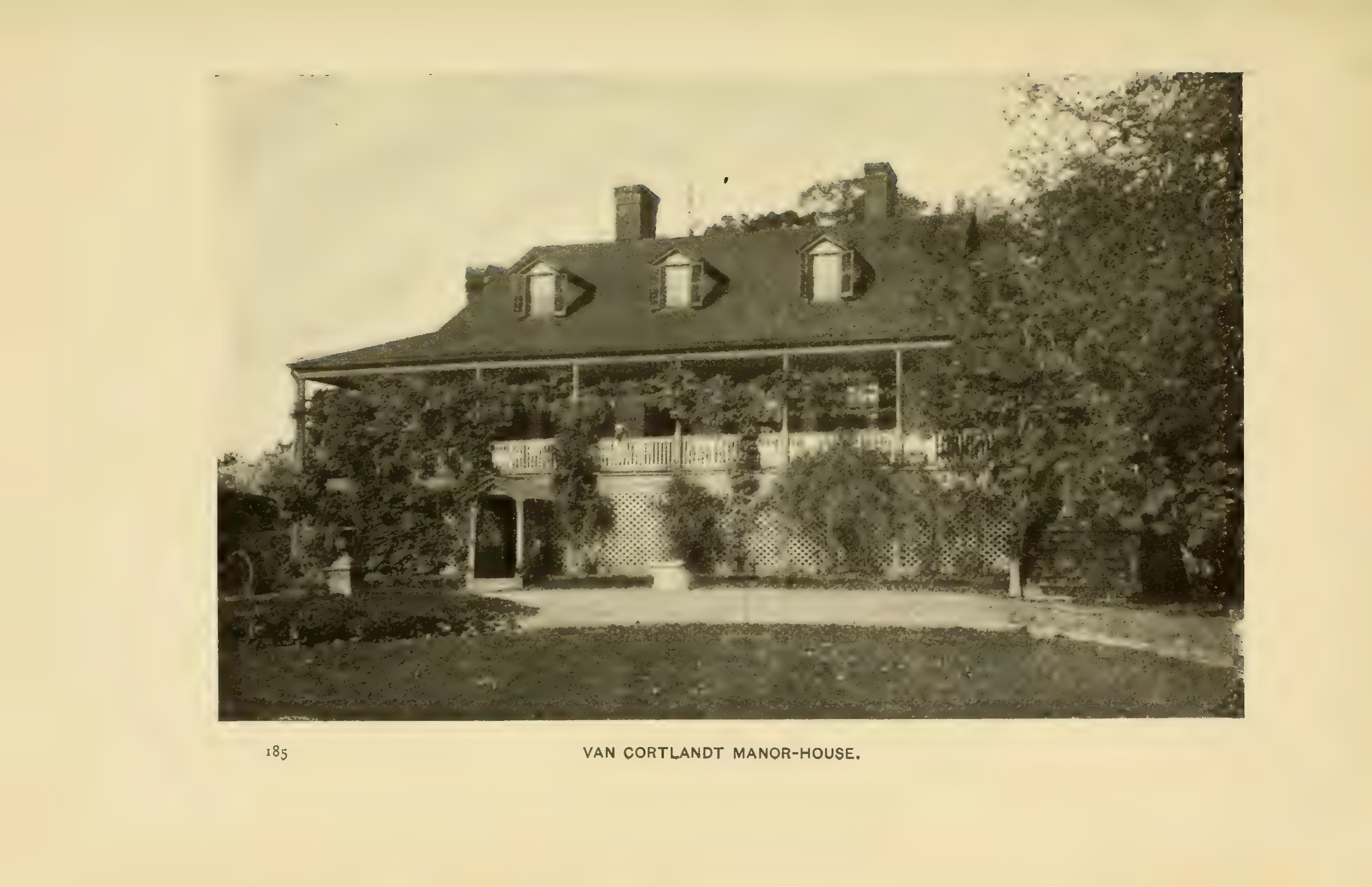
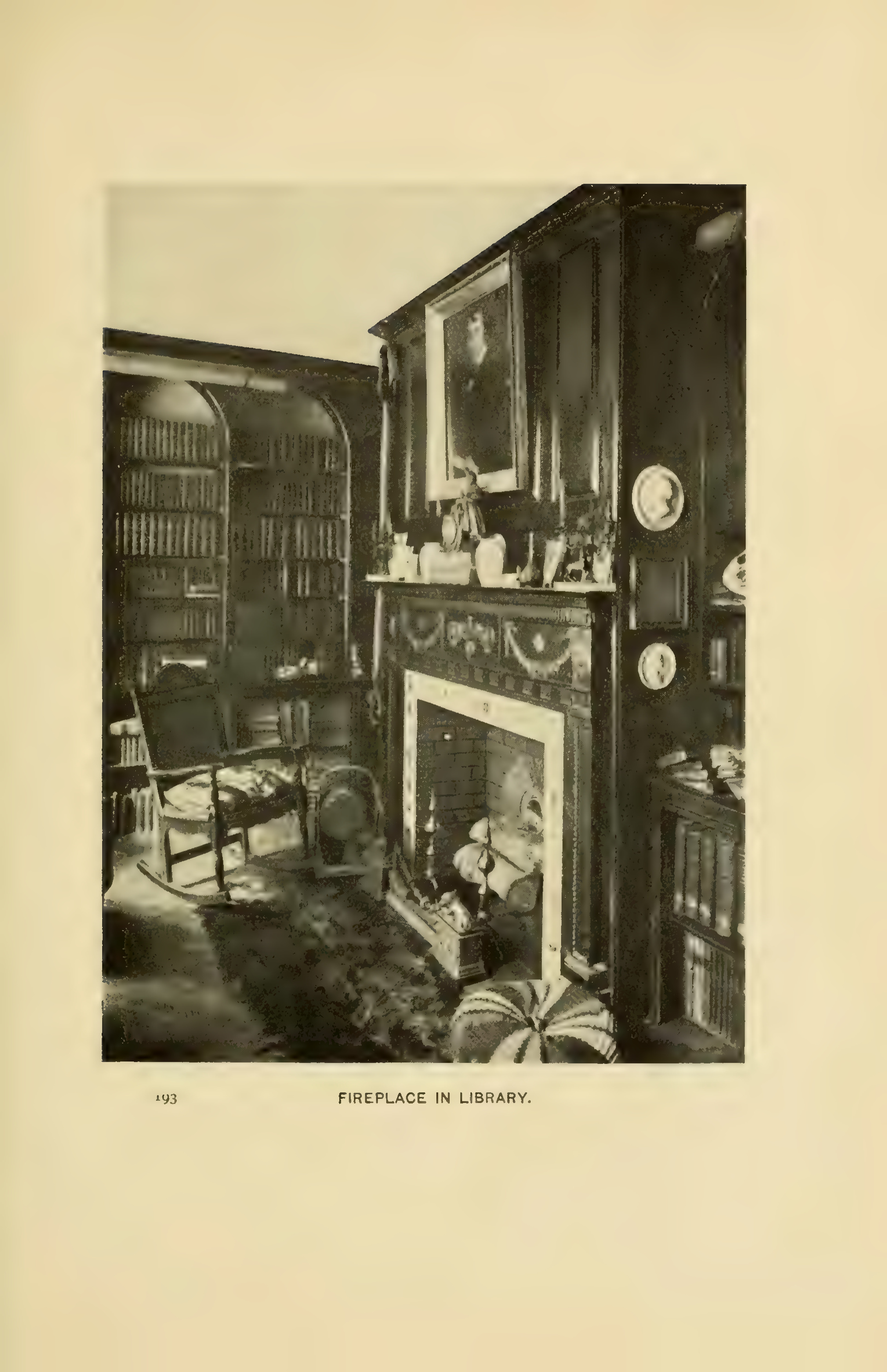
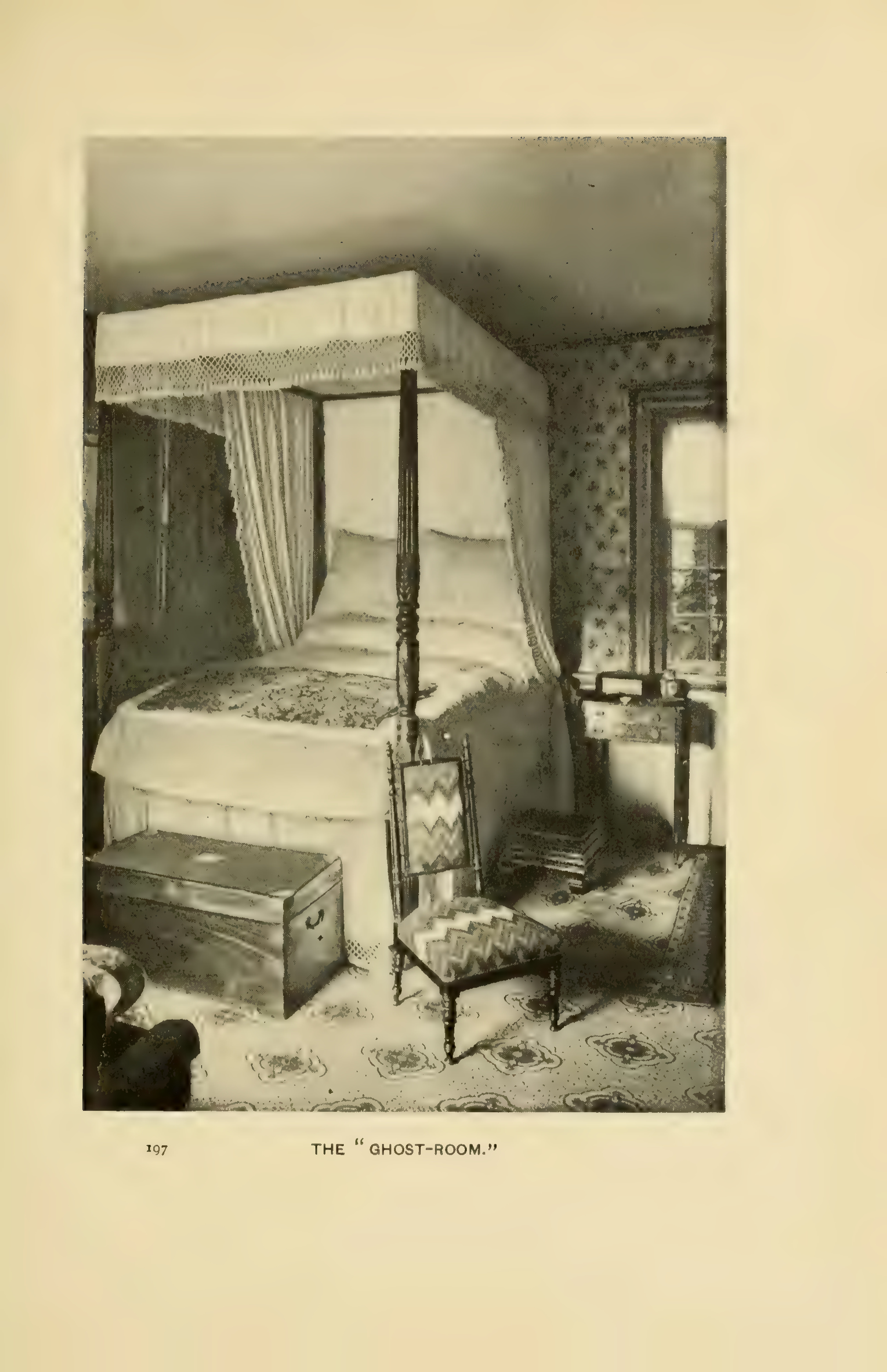
Van Cortlandt Manor Ferry House postcardCirca 1907 · Croton History attributionPostcard reproduced and dated circa 1907 by Croton History, Marc Cheshire. The card bears “J. A. Given”; the imprint’s role and the exact exposure date are not established here. The broad manor marker does not identify the camera position. Source gallery ↗Manor House, south elevation1967Charles Snell, 1967, National Park Service / National Historic Landmarks documentation. Original caption form follows the photograph on PDF page 2. The caption’s December 1974 verification refers to a later visit, not the exposure date. Shown at the general manor site; no separate camera or building position is inferred. Source gallery ↗ · License ↗Manor House, west end and south elevation1967Charles Snell, 1967, National Park Service / National Historic Landmarks documentation. Original caption form follows the photograph on PDF page 6. The caption’s December 1974 verification refers to a later visit, not the exposure date. Shown at the general manor site; no separate camera or building position is inferred. Source gallery ↗ · License ↗Manor House, north elevationDecember 1974Charles Snell, December 1974, National Park Service / National Historic Landmarks documentation. Original caption form follows the photograph on PDF page 4. Shown at the general manor site; no separate camera or building position is inferred. Source gallery ↗ · License ↗Ferry House kitchen exteriorDecember 1974James Dillon, December 1974, National Park Service / National Historic Landmarks documentation. Original caption form follows the photograph on PDF page 16. The form calls this building “Ferry House Kitchen”; the photograph is an exterior view. Shown at the general manor site; no separate camera or building position is inferred. Source gallery ↗ · License ↗Manor House, south front in 200724 November 2007Dmadeo / Wikimedia Commons, CC BY-SA 4.0. Complete native-resolution photograph; the older smaller copy remains in the library’s alternate records. Source gallery ↗ · License ↗Van Cortlandt Manor exterior in Harland’s illustrated volumePublished in 1899 reprint; exact exposure date unknownFull published page from Marion Harland’s Some Colonial Homesteads and Their Stories, 1899 reprint of the 1897 work, PDF p.206. It records a pre-restoration view, not the present appearance or a dated construction campaign. Photographer unidentified. Library of Congress / Internet Archive scan. Source gallery ↗Library fireplace in Harland’s illustrated volumePublished in 1899 reprint; exact exposure date unknownFull published page from Marion Harland’s Some Colonial Homesteads and Their Stories, 1899 reprint of the 1897 work, PDF p.214. It records a pre-restoration view, not the present appearance or a dated construction campaign. Photographer unidentified. Library of Congress / Internet Archive scan. Source gallery ↗Room captioned Ghost-Room in Harland’s illustrated volumePublished in 1899 reprint; exact exposure date unknownFull published page from Marion Harland’s Some Colonial Homesteads and Their Stories, 1899 reprint of the 1897 work, PDF p.218. It records a pre-restoration view, not the present appearance or a dated construction campaign. Photographer unidentified. Library of Congress / Internet Archive scan. Source gallery ↗
A country house, working estate and river crossing meet here. The federal landmark inventory dates Pierre Van Cortlandt’s improvements to 1747–1749 and his year-round residence to 1749; the earliest building phases remain less certain. The manor’s story includes the Van Cortlandts, enslaved Black residents and other workers, as well as travelers using the nearby ferry and tavern. Surviving old fabric, restored buildings and reconstructed service structures together explain the estate visitors see.
An army halt in 1781
On 2 July 1781, George Washington recorded a short halt at the “New bridge over Croton,” about nine miles from Peekskill, while marching south with the Continental Army. His handwritten diary establishes a bridge in use by that day, without dating its construction or the end of ferry service. It does not record a visit to the manor house. The existing manor marker gives the crossing’s general context; the diary does not identify a precise bridge footprint.
What the present buildings preserve
The federal landmark inventory describes the ferry house’s restoration after a twentieth-century fire. It explicitly identifies the ferry dock as a reconstruction. Those features help interpret the crossing, but their present fabric should not all be treated as surviving colonial construction.
Photographs after restoration
The federal record pairs each photograph with its photographer, date and view. Charles Snell’s 1967 views show the south front and west end; his December 1974 view records the north elevation. James Dillon’s December 1974 photograph records the exterior of the building captioned Ferry House Kitchen. These are records of the restored site, not evidence that every visible feature survives unchanged from the colonial period.
How the house grew
The federal architectural inventory describes a stone-and-brick house built into a hillside, with a deep basement, a gambrel roof, a verandah and paired flights of stairs on its south front. It dates substantial improvements for Pierre’s permanent residence to 1747–1749. Its proposed seventeenth-century beginnings are qualified interpretations, rather than a recovered building contract. Later nineteenth-century wings were removed during restoration.
Reading the old walls
The holes in the stonework have sometimes been described as gun loops. The federal architectural account instead identifies them as putlog holes associated with construction, noting that their positions and shapes were unsuitable for eighteenth-century firearms.
The crossing and the Ferry House
The federal inventory describes the Van Cortlandts’ operation of a Croton River ferry and the restored Ferry House nearby. Enough of its heavy oak frame survived an undated twentieth-century fire to establish the building’s form and roof pitch. The same inventory specifically lists the ferry dock and Ferry House kitchen as reconstructions; their appearance should not be confused with unchanged colonial fabric.
Before the twentieth-century restoration
Marion Harland’s Some Colonial Homesteads and Their Stories includes a manor exterior and furnished interiors while the house remained a family residence. The acquired copy is an 1899 reprint of the 1897 work. Its photographs document a pre-restoration appearance, without establishing exact exposure dates or dating every object shown. Harland’s family anecdotes and ghost stories are historical storytelling, not independently verified events.
Location. Present manor-house reference point, not the full estate or the exact landing of the historical ferry.
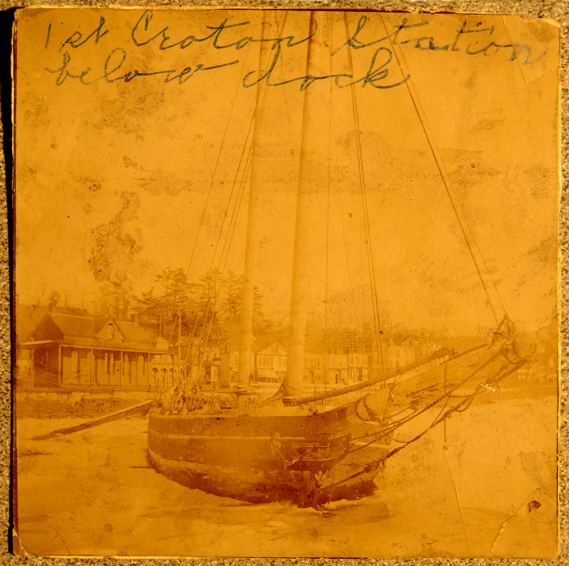
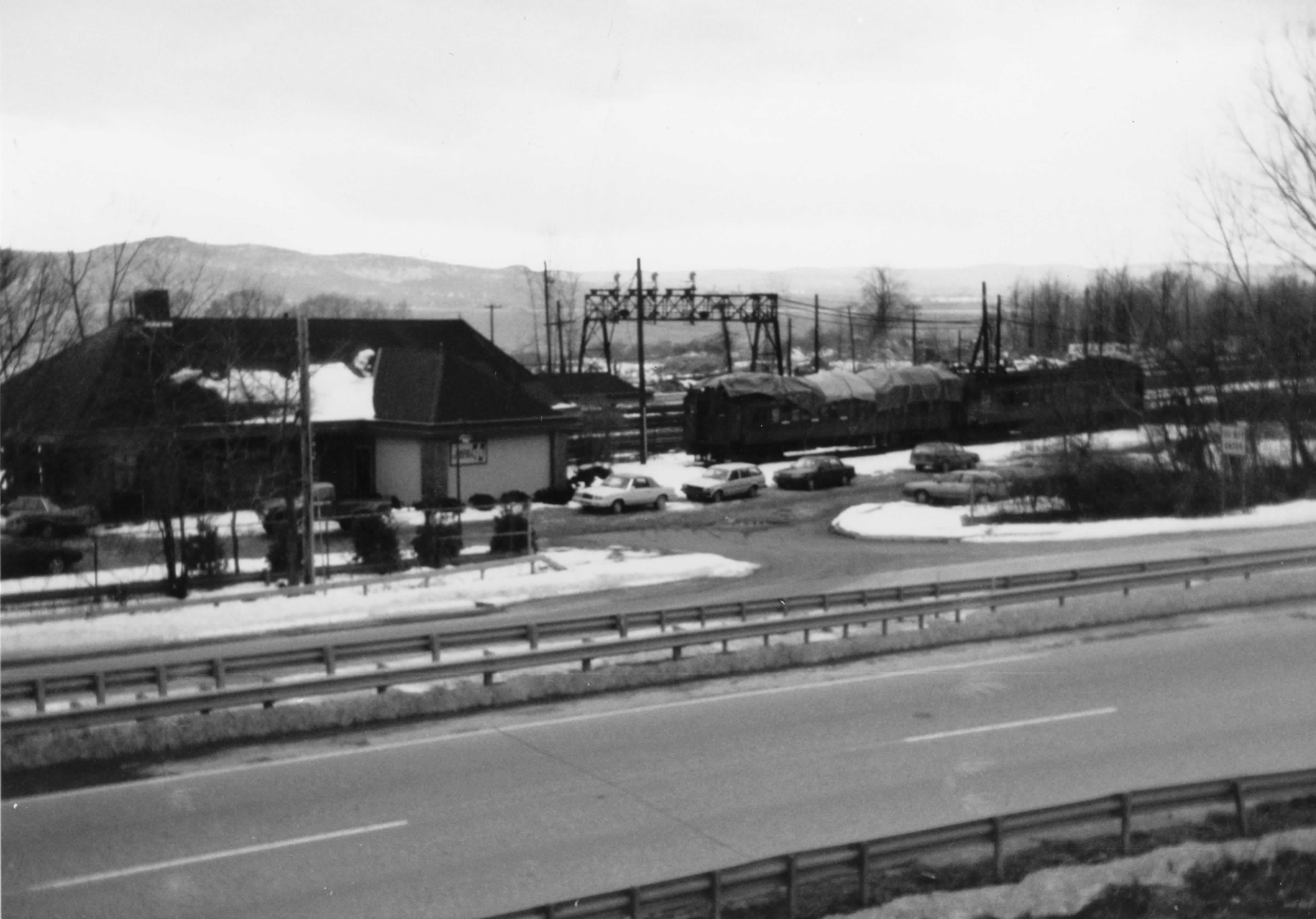
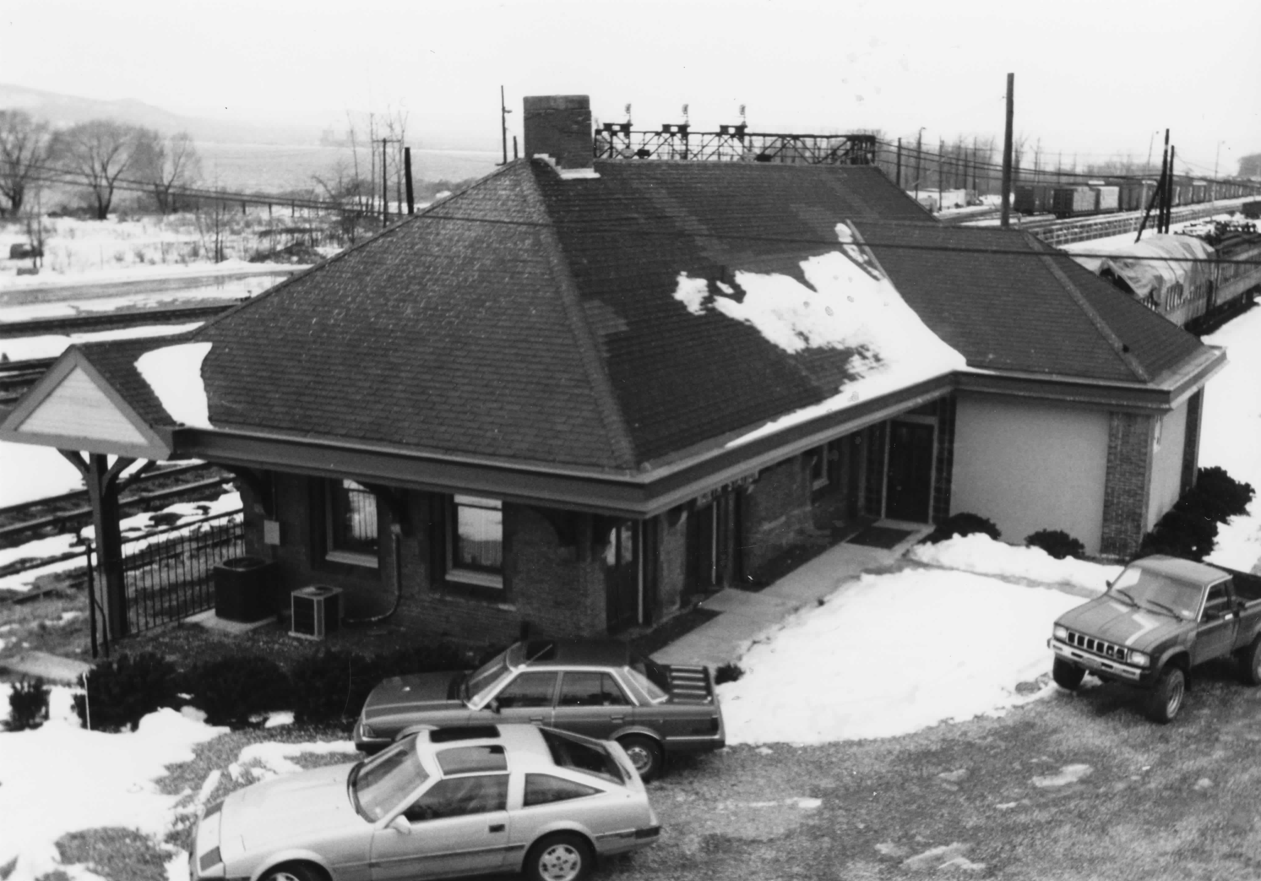
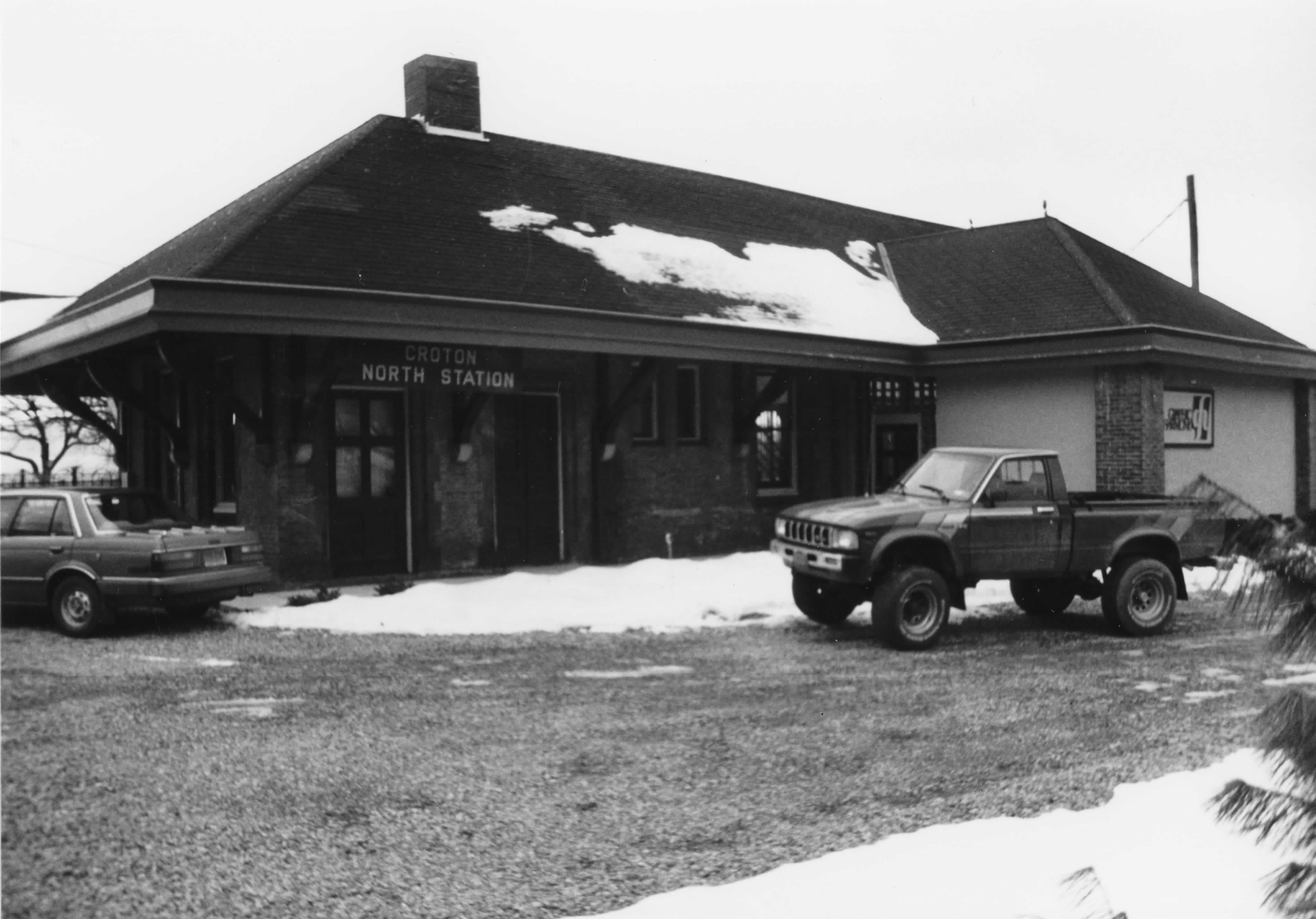
First Croton Landing depot in an early waterfront photographAbout 1849 (attributed by Marc Cheshire); exact exposure date unknownEarlier depot at left with boats in the foreground. Photograph courtesy Ossining Historical Society, shared by Ken Sargeant; research and reproduction by Marc Cheshire / Croton History. Cheshire’s circa-1849 dating is interpretive, not an original dated negative. This is not the surviving circa-1890 building. Source gallery ↗Station and rail setting from the pedestrian bridge1987Station and rail setting from the pedestrian bridge. Photograph by N. Larson, 1987; New York State Division for Historic Preservation, negative collection. Original caption on PDF p.13 of the nomination. This records the station in 1987, not its present condition. No open reuse license stated. Source gallery ↗Station exterior, southeast perspective1987Station exterior, southeast perspective. Photograph by N. Larson, 1987; New York State Division for Historic Preservation, negative collection. Original caption on PDF p.15 of the nomination. This records the station in 1987, not its present condition. No open reuse license stated. Source gallery ↗Another station exterior view1987Another exterior view, labeled southeast perspective on the original reverse. Photograph by N. Larson, 1987; New York State Division for Historic Preservation, negative collection. Caption reverse: nomination PDF p.17. This records 1987 condition, not the present building. No open reuse license stated. Source gallery ↗
Croton North is a surviving small-town depot from the New York Central era, dated circa 1890 by its original National Register nomination. Its wide roof sheltered passengers, while the faceted north end held the waiting room and a projecting bay let staff watch approaching trains. An earlier wooden Croton Landing depot stood nearby. Rehabilitated for offices in 1984, this building preserves a different part of local railroad history from the later Croton–Harmon electric terminal.
An earlier station nearby
The surviving station is distinct from the first Croton Landing station shown in an early photograph and an 1850 map. The National Register lists 1890 and 1930 as significant years; those metadata do not establish two construction dates.
An older depot and a later station
The surviving building is distinct from Croton Landing’s first depot. Marc Cheshire’s Croton History research identifies an early waterfront depot near present Grand Street and North Riverside Avenue and tentatively dates its photograph to about 1849 by comparison with an 1850 survey. That photograph is not a dated construction record and does not place the first depot on this building’s footprint.
When was this building built?
The 1987 National Register nomination explicitly dates construction to circa 1890. Its architect/builder field says unknown; its narrative attributes small-station designs such as Croton North to New York Central’s engineering office. No named architect, construction contract or exact opening day has been independently established.
Architecture that explains the journey
The nomination describes brick walls, terra-cotta door and window surrounds, a broad hipped roof and shaped wooden braces. The windowed, faceted north end housed the waiting room. A projecting trackside bay let ticket and control staff watch approaching trains; baggage and toilets occupied the south end. The carriage entrance and deep canopy sheltered passengers moving from street vehicles to trains. This blend of practical transport design and Queen Anne influences explains its architectural significance.
Reused without losing the whole station
The street-side carriage shelter was enclosed in the 1970s. In 1984 the building was rehabilitated for offices, with skylights, glass block and new partitions; the tall waiting-room ceiling was retained, and new partitions recalled the original business-area configuration. The nomination’s broad statement that original use continued into the 1960s does not establish a final passenger-service date.
The coaches were added later
The nomination records two 1930 Pullman-Standard electric coaches installed on display track in 1986. They were built for Erie service in New Jersey and were not original Hudson Line equipment. Their presence in the 1987 listing must not be mistaken for the station’s construction date or operating history.
Location. Existing station building at 1 Senasqua Road; modern building reference, not the complete historical station grounds.
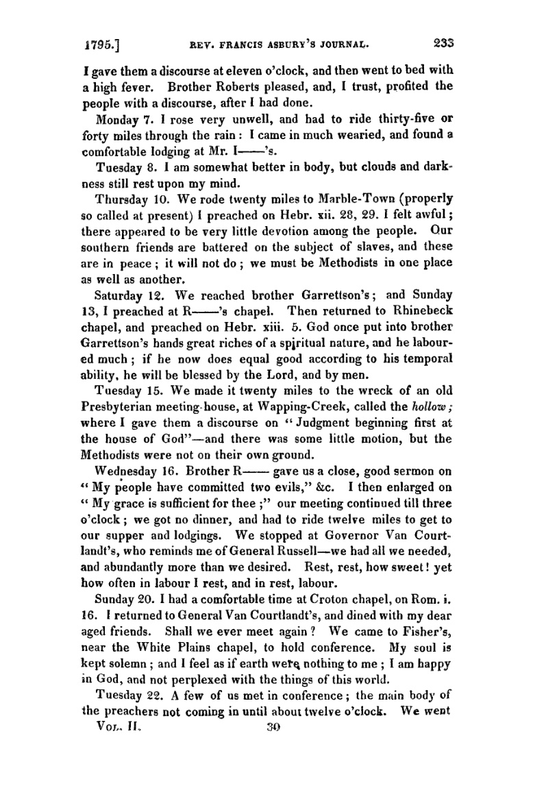
Asbury’s Croton chapel entry, September 20, 1795Printed p.233 of the 1821 journal edition. The September 20 entry names Croton chapel; the National Register nomination identifies it with Bethel. Emory University, Pitts Theology Library / Internet Archive scan. A published diary page, not the original manuscript.
Historic images
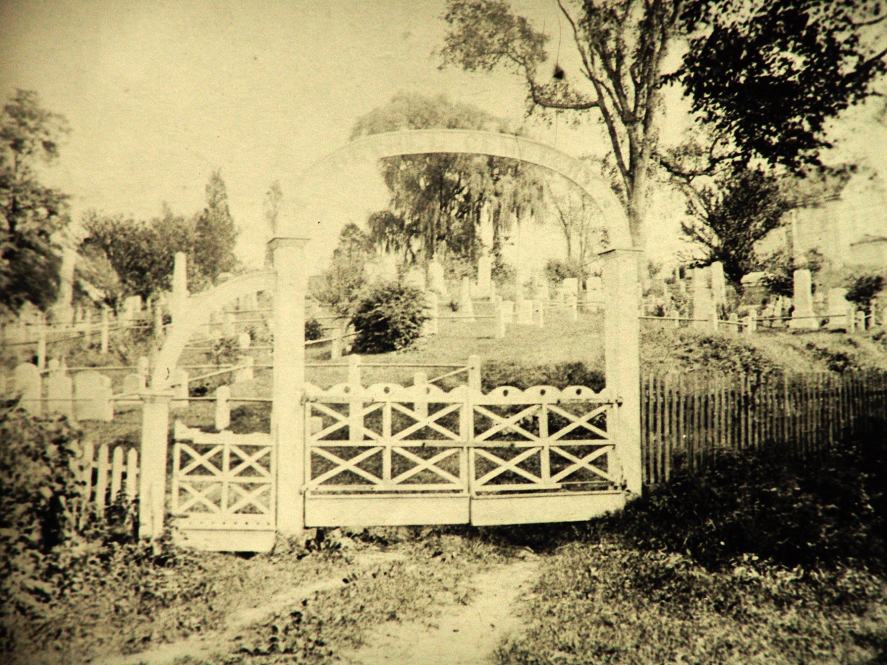
Bethel’s wooden entrance gatewayCirca 1860–1870, attributed by Croton HistoryLightened reproduction published by Marc Cheshire / Croton History. Ken Sargeant photographed an image in the Ossining Historical Society collection; the original photographer is unidentified. This adjusted view is easier to read; the larger unretouched version remains in the photo library. It is not a photograph of Hansberry’s grave. Source gallery ↗
Bethel’s small clapboard chapel and surrounding cemetery preserve the meeting-house setting of Croton’s early Methodist congregation. The National Register nomination dates the chapel to about 1790. Francis Asbury’s published journal records a visit to Croton chapel on September 20, 1795; the nomination identifies that chapel with Bethel. Its plain timber interior and later additions tell a longer story than a single founding date.
Croton’s early Methodist circuit
The church’s official 1840 compilation of conference minutes lists Peter Moriarty assigned to Croton in 1792, followed by Sylvester Hutchinson and Jacob Egbert in 1793. Both lists place Croton under Jacob Brush. These appointments document regional Methodist activity before the 1795 chapel visit recorded by Asbury; they do not identify Bethel Chapel or date its construction.
A plain meeting house
The 1999 architectural survey describes a nearly square chapel on granite slabs, with a gallery, heavy mortise-and-tenon framing, wide floorboards, an altar rail and simple wooden pews. It records nineteenth-century kerosene lamps and a lectern. These are observations of surviving fabric at the time of the survey, rather than proof that every fitting dates to the original building.
The journal behind the 1795 visit
In the 1821 edition of his journal, Asbury records a comfortable time at Croton chapel on September 20, 1795, followed by dinner with General Van Courtlandt. The previous page establishes the September sequence. Asbury does not call it Bethel by name; that identification follows the National Register research. This is a checked published diary edition, not the autograph manuscript or a construction record.
An unresolved claim
The cited study asks whether Native people and enslaved Africans were buried here. It does not establish those burials. This atlas therefore does not label Bethel a confirmed Native burial site.
Lorraine Hansberry and Cleveland Drive
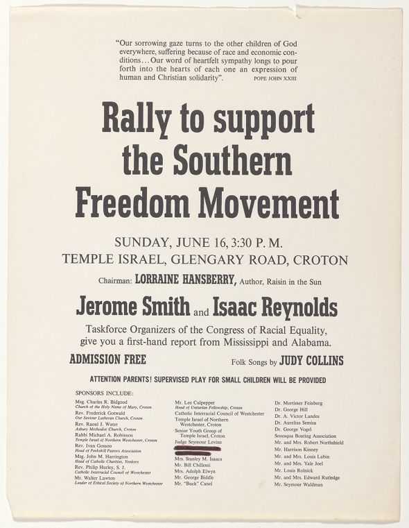
Playwright Lorraine Hansberry is buried at Bethel. In 2026, trustees approved Lorraine Hansberry Way as an honorary co-name for Cleveland Drive between Old Post Road South and Gerstein Street. This added a commemorative name without changing the postal street name. The formal resolution says Way; an earlier passage in the same minutes says Place.
Chapel dates and early records
The National Register nomination dates the chapel to circa 1790 and treats the 1777/1780 gift and 1780 construction dates as local traditions without a surviving transaction document. Its cited September 20, 1795 Croton chapel reference has now been checked in the 1821 published journal. Earlier conveyances and the original journal manuscript remain unexamined.
Changes to chapel and cemetery
The nomination records a rear equipment enclosure added in the 1920s, interior replastering in 1936 and a two-acre cemetery expansion in 1937. The expansion concerns cemetery land, not a larger chapel. These dates come from the later survey; the original building accounts and conveyance have not been independently checked.
Reading the cemetery
The cemetery’s carved stones preserve names and changing memorial styles. The local history study also notes that wooden and simple fieldstone markers have not survived, leaving a less complete record than the visible monuments suggest.
Location. Chapel and adjacent cemetery locality on Old Post Road South; no individual burial is plotted.
The successor to Bethel Chapel was dedicated in 1883. The National Register nomination records a building committee meeting on September 13, 1875, a planning milestone rather than proof of completion that year. The brick Gothic church has a slate roof.
From Bethel to Asbury
The nomination quotes a committee account naming E. A. Baker to oversee masonry. It records the Epworth League’s gift of the main façade window in 1891 and a pipe organ given by Andrew Carnegie in 1912. The architect is unidentified; local manufacture of the bricks is an inference in the nomination.
Location. Existing church building at 17 Old Post Road South.
The municipal building was Croton Union School from 1909 to 1939. Today’s Van Wyck Street entrance was the school’s rear.
A school adapted for municipal use
The village’s 2015 report records a replacement roof in 1978 and foundation waterproofing and an accessibility lift in 1994. It also describes the newly awarded roof and masonry repair contract; that announcement does not establish when the work finished.
Location. Existing municipal building at 1 Van Wyck Street; marker represents the building, not former school grounds.
The 1857 brick church was built on land given by Philip Van Wyck, at the Grand Street and Old Post Road corner.
The mission before the building
The diocesan history published in 1886 dates mission organization to 1854. The 1903 clerical directory identifies Augustus Vallette Clarkson as rector at Croton with the same date. These are records of ministry and organization, separate from the existing church building’s 1857 construction date.
Church, parish hall and rectory
The National Register nomination traces the 1857 church to builder Seth Bird and an adaptation of his Tarrytown church. Its chronology, drawn largely from a 1987 parish history, dates the parish hall to 1882 and the rectory to 1910. George Baker supplied the rectory plans.
The 2006 record
The signed nomination records National Register entry on July 26, 2006. Four photographs by Ty West, taken in March 2006, document the exterior, bell cote and nave. The packet includes a tax map of the church, parish hall and rectory as nominated.
Land, plans and construction
The nomination reports receipt of Philip Van Wyck’s deed on October 8, 1855, with a two-year building condition. An earlier design was abandoned. In July 1857 the vestry contracted with Seth Bird for a brick adaptation of his Tarrytown church, with a modified roof. The cornerstone followed on July 30 and completion in late October. This sequence follows the nomination’s use of Michaelsen’s parish history; the early deed and vestry originals have not been inspected.
Location. Existing church near Grand Street and Old Post Road; modern building reference.
Dam construction at Silver Lake1961 — attributed by Croton Friends of HistoryFrom Carl Oechsner’s Silver Lake article for Croton Friends of History. The article supplies the year; the original photographer is unidentified. Shown at the general Silver Lake locality, not a surveyed camera point. Source gallery ↗
Local research follows the access disputes of the 1930s and the opening announced for July 1, 1938. It distinguishes Silver Lake from the deeper Diana’s Pool beyond the rock jetty.
Location. Generalized present swimming-area locality on the Croton River; the circle is not the historic pool boundary.
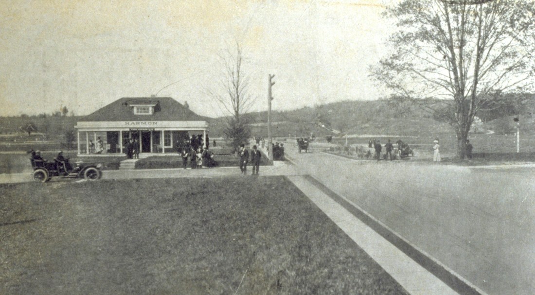
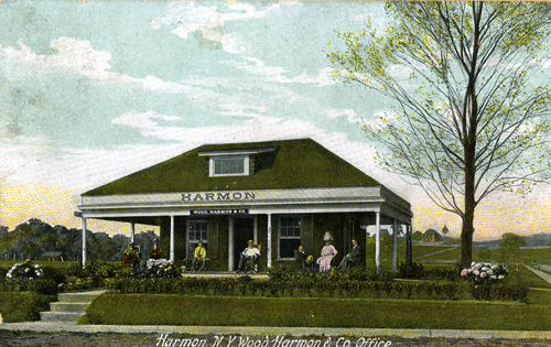
Harmon sales office and Benedict BoulevardCirca 1907, attributed by CrotonHistoryPromotional postcard view of the Harmon sales office and Benedict Boulevard at Broadway. Marc Cheshire’s CrotonHistory article dates the card circa 1907; the precise exposure date and original photographer are unestablished. The full held image preserves the broad street setting. Credit: Marc Cheshire / Croton History (crotonhistory.org). Original photographer unidentified; used with attribution, consult CrotonHistory for permissions. Source gallery ↗A colored postcard of the Harmon sales officeEarly twentieth century; precise postcard and exposure dates unestablishedA different colored postcard view captioned “Harmon, N.Y. Wood, Harmon & Co. Office”, reproduced by Marc Cheshire/CrotonHistory. The source identifies the office at South Riverside Avenue and Benedict Boulevard. The original photographer, publisher, reverse and precise date have not been established. Credit: Marc Cheshire / Croton History (crotonhistory.org). Original photographer unidentified; used with attribution, consult CrotonHistory for permissions. Source gallery ↗
Clifford Harmon’s sales office at Benedict Boulevard and South Riverside Avenue survives from the promotion of his suburban development.
Read the two sides separately
The lot plan is dated 1907. Its promotional reverse advertises a house-building offer expiring September 1, 1913. Together they document surveying and later promotion; the later advertising cannot be treated as a picture of everything present in 1907.
Selling Harmon before the improvements were finished
The Katonah Times reported on May 24, 1907 that Harmon had recently been laid out into village lots. It described a May 5 excursion train from Grand Central and said Clifford B. Harmon had intended a June 1 opening while improvements were still under way. Its enthusiastic account describes the sales campaign; it does not establish when this office was built. Marc Cheshire / Croton History identified the newspaper report and reproduced the two postcard views shown here.
Location. Modern address reference at 1 Benedict Boulevard; historical office identified by the postcard tour.
Later histories date Clifford Harmon’s Japanese-inspired tea house to 1907 and describe conversion to a private home. The competing Nordica Drive addresses have not been reconciled with the mapped locality.
Address and surviving-building accounts
Former inn locality. The 2016 Town inventory lists 66 Nordica Drive, while Friends of History gives 80 Nordica and describes a surviving private residence. Parcel identity and address history have not been reconciled; no exact surviving-building identification or demolition is established here.
Location. Historical building locality on Nordica Drive. It is now private property, not a public attraction.
The nature center occupies a former stable from the estate landscape. Teatown’s institutional history traces the preserve to the Swope family’s land gift and its development into a conservation and education organization.
The landscape protected in 2018
Teatown’s annual report records a May 18, 2018 conservation easement protecting 245 acres, including the lake, Wildflower Island, nature center and trails. The building marker represents one place within that larger protected landscape.
Location. Nature-center building reference at 1600 Spring Valley Road; the circle does not represent the full preserve.
Saw Mill River Audubon managed the Brinton gift from 1958 and assumed ownership in 1991. Later gifts expanded the sanctuary and connected its trails to village land.
Connecting protected land
Ruth Brinton Perera added 17 acres in 1975. In 1995 the Coyote Trail connected the sanctuary with a 27-acre village parcel. Audubon’s account distinguishes management, ownership and trail access; the combined landscape is not one deed parcel.
Location. Representative point inside the sanctuary, not a trailhead or property boundary.
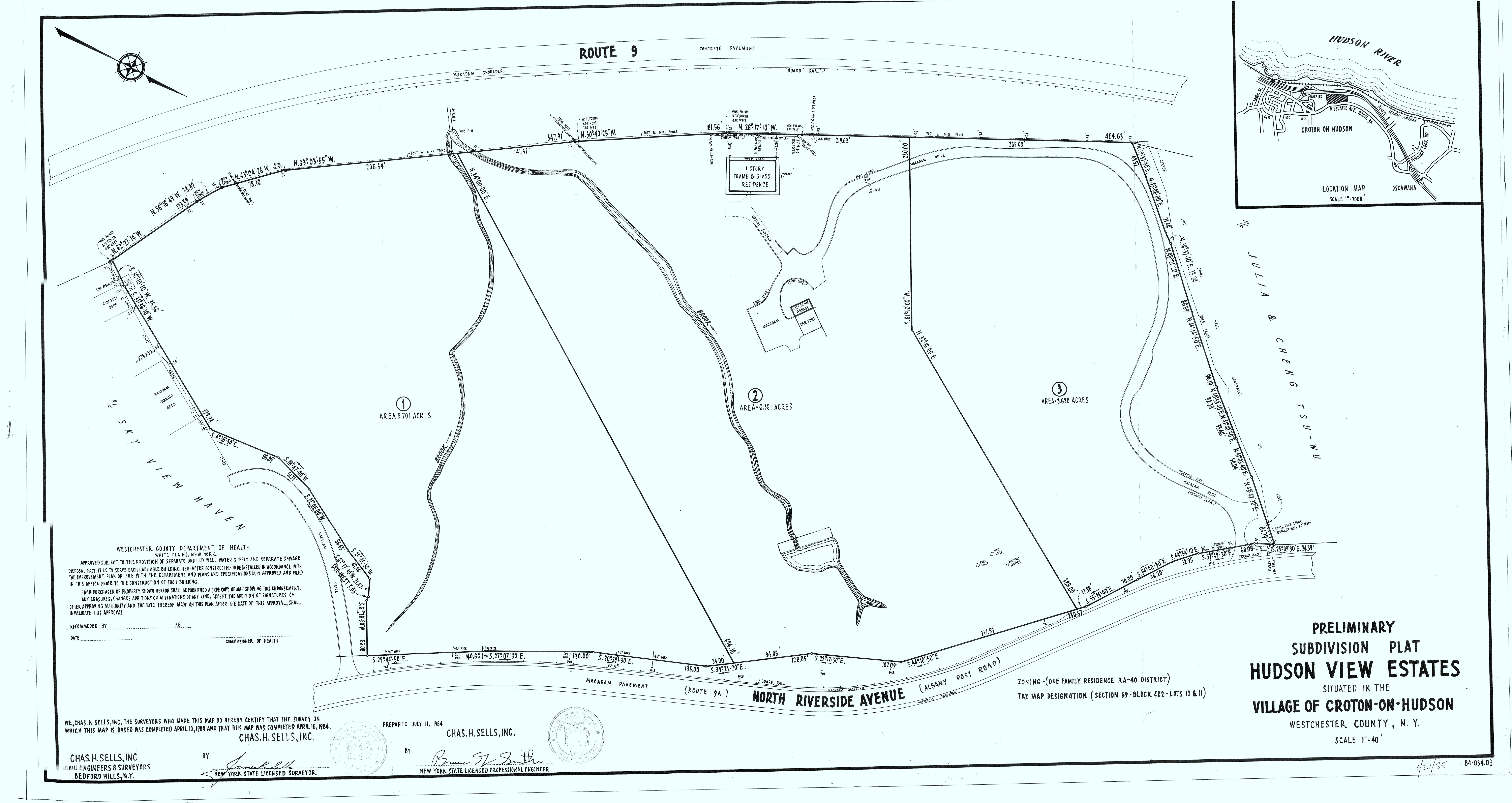
Hudson View Estates — preliminary subdivision platChas. H. Sells, Inc., July 11, 1984. A three-lot proposal, not proof of a completed subdivision. Open the full drawing to inspect the house, garage, drive, brooks and pond.
Historic images
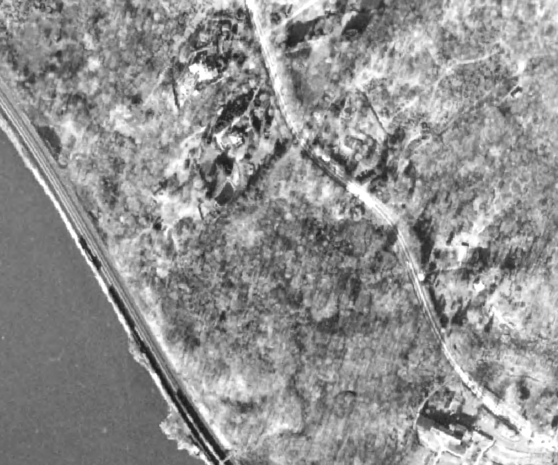
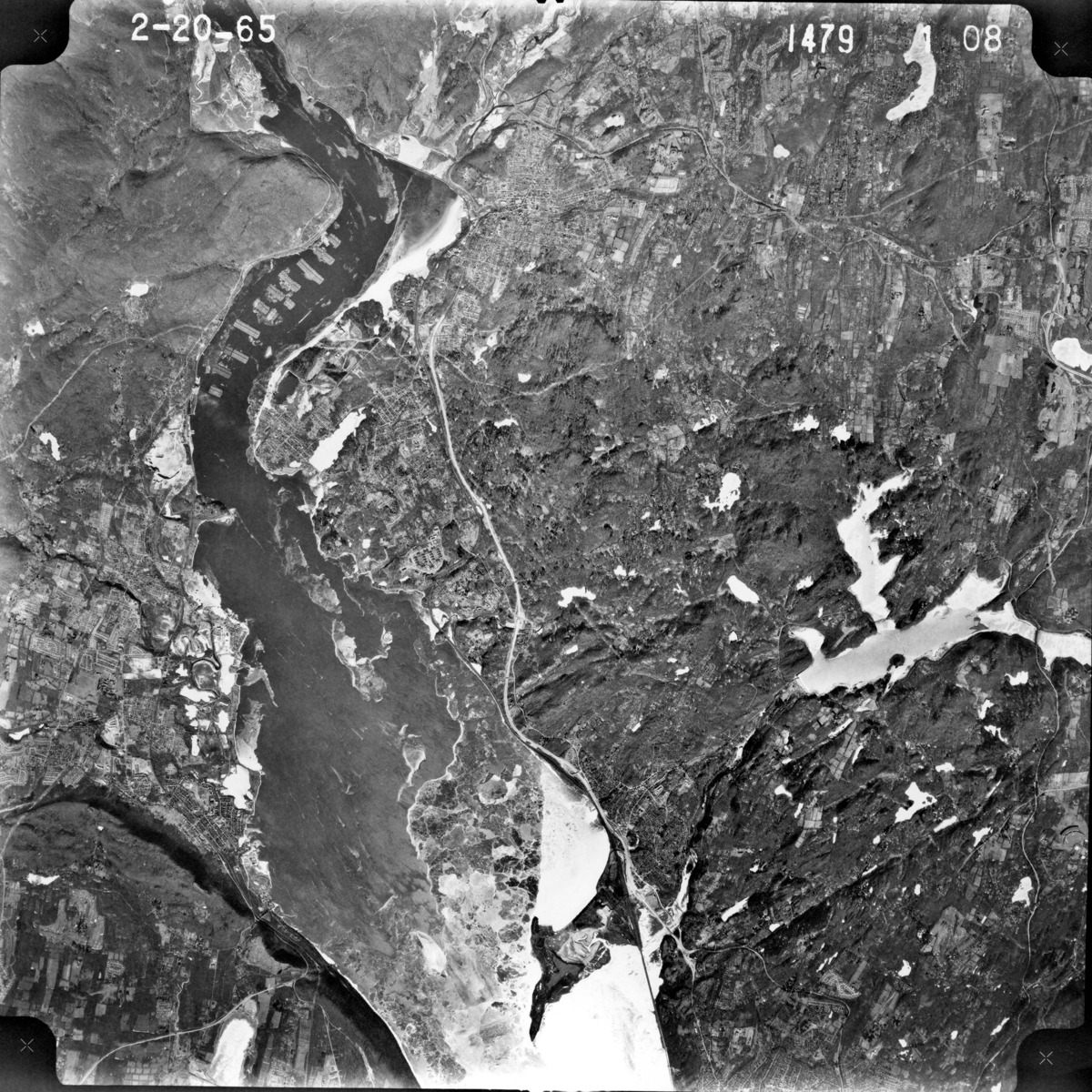
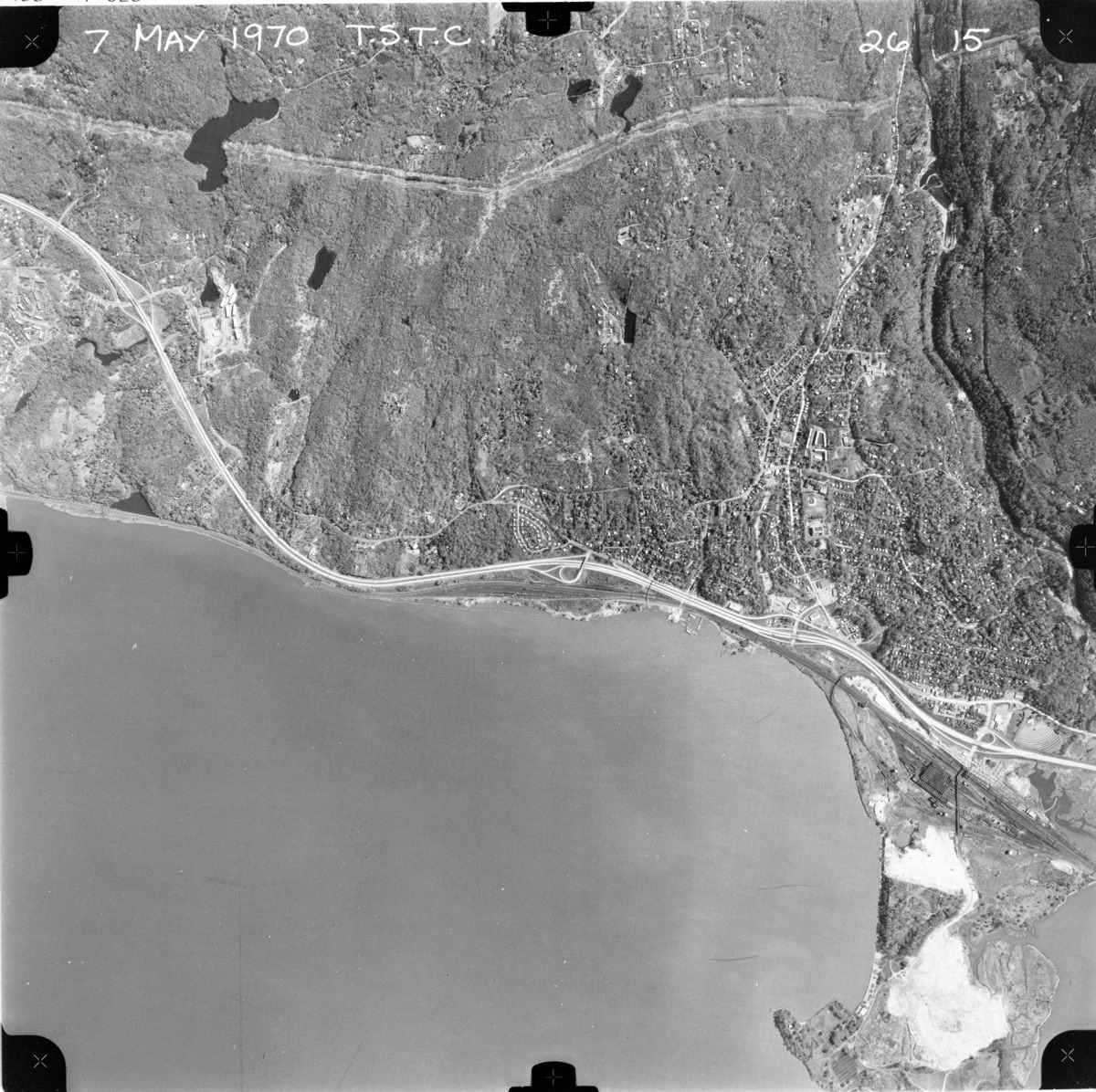
Gouveia locality from the air, 1960November 1960 · county flight seriesAmerican Air Surveys, Inc. / Westchester County GIS. Wooded ground before the Jurka house’s permit and occupancy records. County composite excerpt; the local exposure day is unidentified. Compare the two years in Map layers. Source gallery ↗Gouveia locality from the air, 1976March 1976 · county flight seriesAerial Data Reduction Assoc., Inc. / Westchester County GIS. The Jurka-era house and grounds before Gouveia ownership. County composite excerpt; the local exposure day is unidentified. Compare the two years in Map layers. Source gallery ↗Croton and the Gouveia vicinity — individual flight print, 196520 February 1965Westchester County Historical Aerial Photograph Collection; creator unlisted. Complete winter frame, including the Hudson, Croton Point and the Gouveia vicinity. Source gallery ↗Croton and the Gouveia vicinity — individual flight print, 19707 May 1970Westchester County Historical Aerial Photograph Collection; series credited to Raytheon Co., frame marked T.S.T.C. Complete regional frame; the visible scan pattern is also in the source PDF. Source gallery ↗
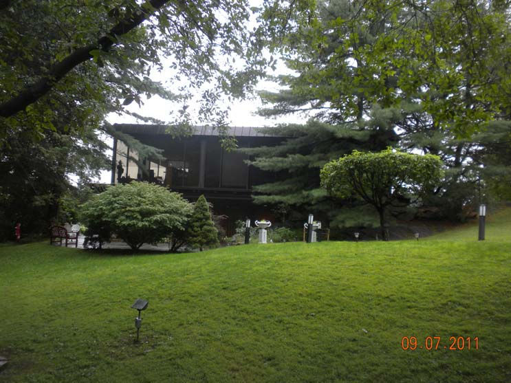
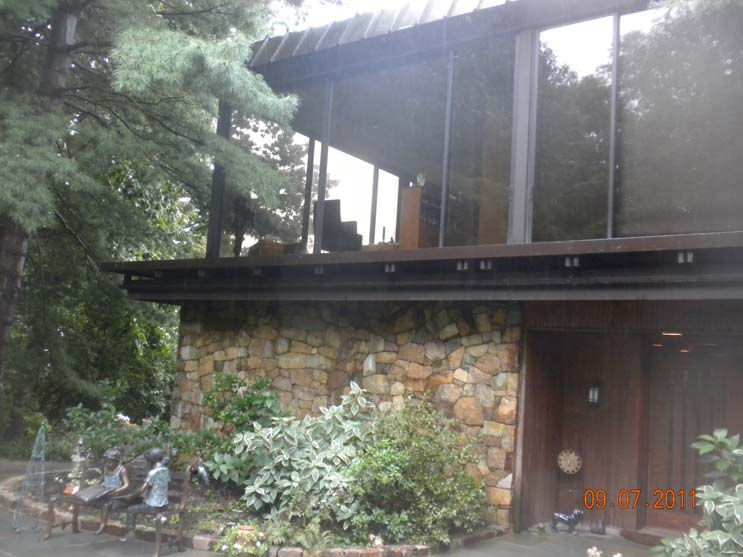
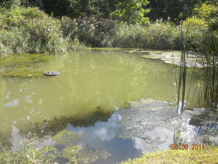
The 15.69-acre park contains the former Jurka–Gouveia house, a pond, woodland streams and estate outbuildings. Building records identify Edward G. Schildbach as architect for Dr. Edith M. Jurka. Laurel Gouveia later gave the property and a $1 million endowment to the village; public park use followed in July 2017.
Gift, title and opening
The village’s contemporary newsletter dates the title transfer to June 4, 2015. Its later park history says public use began in 2017. These were separate milestones; the earlier conditional acceptance did not itself transfer title.
Before the park: Jurka and the Gouveias
Michael Balter’s Croton Chronicle family history, based on research and photographs supplied by Heidi Jurka, dates Edith Jurka’s purchase to 1962 and calls the house The Aerie. In a first-person interview recorded in the 2011 assessment, Laurel Gouveia said she had owned the property since 1984. These accounts precede the village’s acquisition; they are not substitutes for the original deeds.
A subdivision that remained a proposal in this record
Chas. H. Sells, Inc. prepared the Hudson View Estates preliminary plat on July 11, 1984, using an April 16 survey. Its three proposed lots total 15.690 acres. The drawing is useful evidence of the buildings and landscape then recorded; the word preliminary matters. No later subdivision approval or conveyance is established by this sheet.
The gift and the public grounds
The Board’s November 2013 conditional agreement, January 2015 acceptance of the bequest, June 4 title transfer and July 2017 park opening were separate steps. The 2013 full minutes record a 4–1 vote; the standalone resolution extract’s 4–0 wording conflicts with its own notation of a dissent.
What the gift sought to preserve
The village’s August 2023 account says the gift required a public park in memory of Laurel and John Gouveia and retention of metal statuary, the mailbox, and a bench with children and a horse. That account also describes latitude to adapt buildings while maintaining the public park setting. It is a municipal summary of the will, not a newly examined deed or present-use ruling.
Read the aerials as dated evidence
The 1960 and 1976 Gouveia layers cover the same locality. They bracket the house’s permit and occupancy records and show changes to the surrounding roads and grounds. The county has already aligned these composites; residual photographic distortion remains. Neither layer supplies a legal estate boundary.
Earlier aerials reviewed in the environmental assessment
Tri-State Engineering’s September 2011 assessment describes the 1953 and 1964 aerials as showing vacant land at the subject property. It identifies the main house in the 1974–2006 aerials and says tree cover obscured the outbuildings. This is the assessor’s interpretation; it does not establish that all earlier land use or small structures were absent.
Location. Representative point in the present park at 1300 Albany Post Road; circle is not the parcel boundary.
The village’s May 2008 newsletter describes a 2,300-foot RiverWalk extension and recreation plans. Those records help date the conversion of a working waterfront into today’s public riverfront.
From construction to reopening
The May 2008 plans were followed by continuing work reported in September. By December, the village newsletter described the park as newly reopened. That establishes completion by December, rather than the summer date originally forecast.
Location. Representative point in the current waterfront park, not the extent of the older settlement called Croton Landing.
Brennan’s field report describes pottery and stone tools from two places at Crawbuckie Beach, on the Hudson below the Croton River mouth. He compares them with Kettle Rock and notes differences in pottery, point forms and small scrapers.
What the comparison shows
The paper describes Vinette I-like pottery in distinct archaeological contexts. Its proposed relationships among groups are the author’s interpretation, not a reason to assign every local deposit to one named people or one date.
Location. Generalized Ossining shore south of the Croton River mouth. This does not identify either collection locus or equate the site with the modern preserve boundary.
Parker’s Westchester inventory lists a fort and village between Annsville and Peekskill creeks. It is number 1 on his county map. The description records an early historical site report; it is not a modern excavation plan.
Reading the inventory
Parker warned that his maps and descriptions were preliminary and could contain errors inherited from informants and the base map. The regional layer preserves his symbol so it can be read against the text.
Following the citation backward
The earlier account is Bolton’s 1881 description of a fort and village at Wishqua, in the Annsville area. Beauchamp later cites that history, and Parker repeats the locality. This is a chain of reporting, not three independent excavations.
Location. Broad creek-junction vicinity north of Peekskill. The atlas does not reconstruct the enclosure or identify a surviving earthwork.
Parker’s numbers 7 and 8 report villages on the east and south sides of Indian Hill, calling the nearby lake Mohegan. Yorktown’s adopted historic-resource inventory instead places an Indian Hill Native locality on the shore of Lake Osceola. The atlas uses the Osceola–Jefferson Valley vicinity as a working interpretation, while retaining Parker’s conflicting wording.
Why the sources disagree
The municipal inventory and the hill’s Jefferson Valley geography favor this locality over today’s Mohegan Lake. They do not prove that Parker’s two numbered reports describe the same remains as the municipal record. Both original symbols remain visible in the Parker overlay.
Location. Broad Indian Hill and northern Lake Osceola vicinity, not the modern village of Mohegan Lake. The circle does not identify a burial ground, surviving structure or archaeological boundary.
Parker’s number 10 describes a village north of the Croton River, near historical Croton Lake. A 2004 aqueduct archaeology assessment connects the record with the Deer Pond area and a State Museum site entry. It expressly says there is no clear agreement about the location.
Landmarks help, but do not settle it
The assessment relates Parker’s road, brook and Bald Mountain description to the area northwest of the Croton Lake Gate House. Parker thought reservoir construction had probably erased the site; that is his conclusion, not a modern excavation result.
Reading the project map
Figure CLG-1 locates Deer Pond, the reservoir and gatehouse. Its “Site” arrow identifies the aqueduct project, not the Native village. It is linked as a geographic reference, not presented as a village plan.
Location. Broad north-shore/Deer Pond reading area around the old Croton Lake gatehouse landscape. Conflicting descriptions prevent a precise village pin. The circle is an editorial guide, not a surveyed site extent.
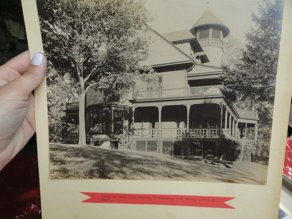
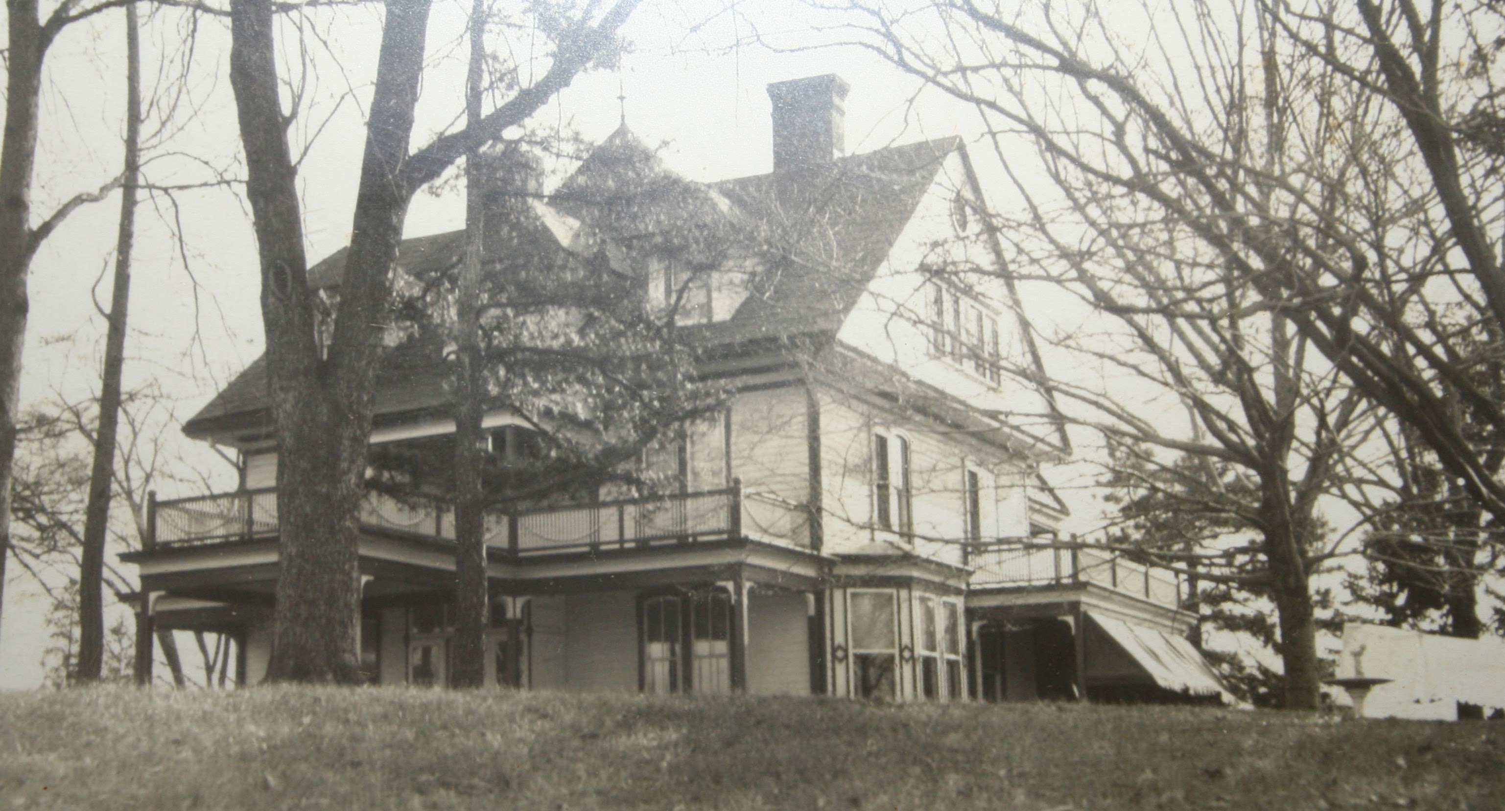
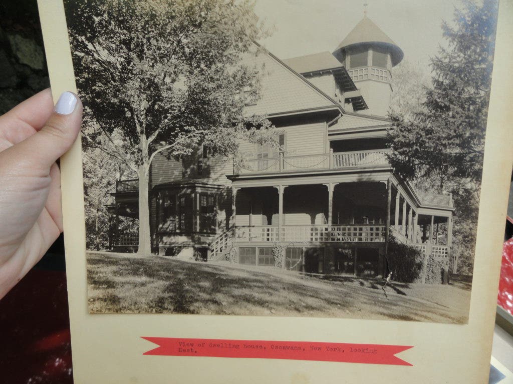
Main dwelling, looking eastOct–Nov 1911 (attributed)Ballard photograph, dated by the album title page compiled in 1964. Original reproduction hosted by Patch. Source gallery ↗Main dwelling, west sideHistoric photograph · exposure date unknownA separate west-side exterior of the main dwelling, preserved in the estate research archive. Its exposure date is unconfirmed. Source gallery ↗
The ruins inland from Oscawana Island belonged to Long View, an estate assembled by tobacco merchant and horse breeder Guillaume Reusens. Ownership later passed through the De Ridder family to Anne and Martin McAndrews. The main house, working buildings, track and water system occupied different parts of the hillside.
A purchase in the original record
The May 12, 1888 Real Estate Record reports that G. Reusens paid $7,650 for a house and six acres at Oscawana. This documents one purchase, not the size or boundary of the whole estate.
People behind the estate
The town’s history identifies horse trainer Algot Johnson, cook Hilda Johnson and housekeeper Amanda Johnson among the estate’s workers. The Johnson household gives this landscape a history of employment and family life as well as ownership.
Leaving Long View
In his 2011 interview, Martin McAndrews Jr. recalled the family’s departure and the estate’s decline. Pomeroy reports that his father left permanently in 1962, tried to sell the property, and disputed the county’s purchase price. This is an attributed family account, not a substitute for the acquisition file.
Location. Approximate position checked against the estate diagram and present-day mapped remains. The circle is a reading area, not a measured building or property boundary.
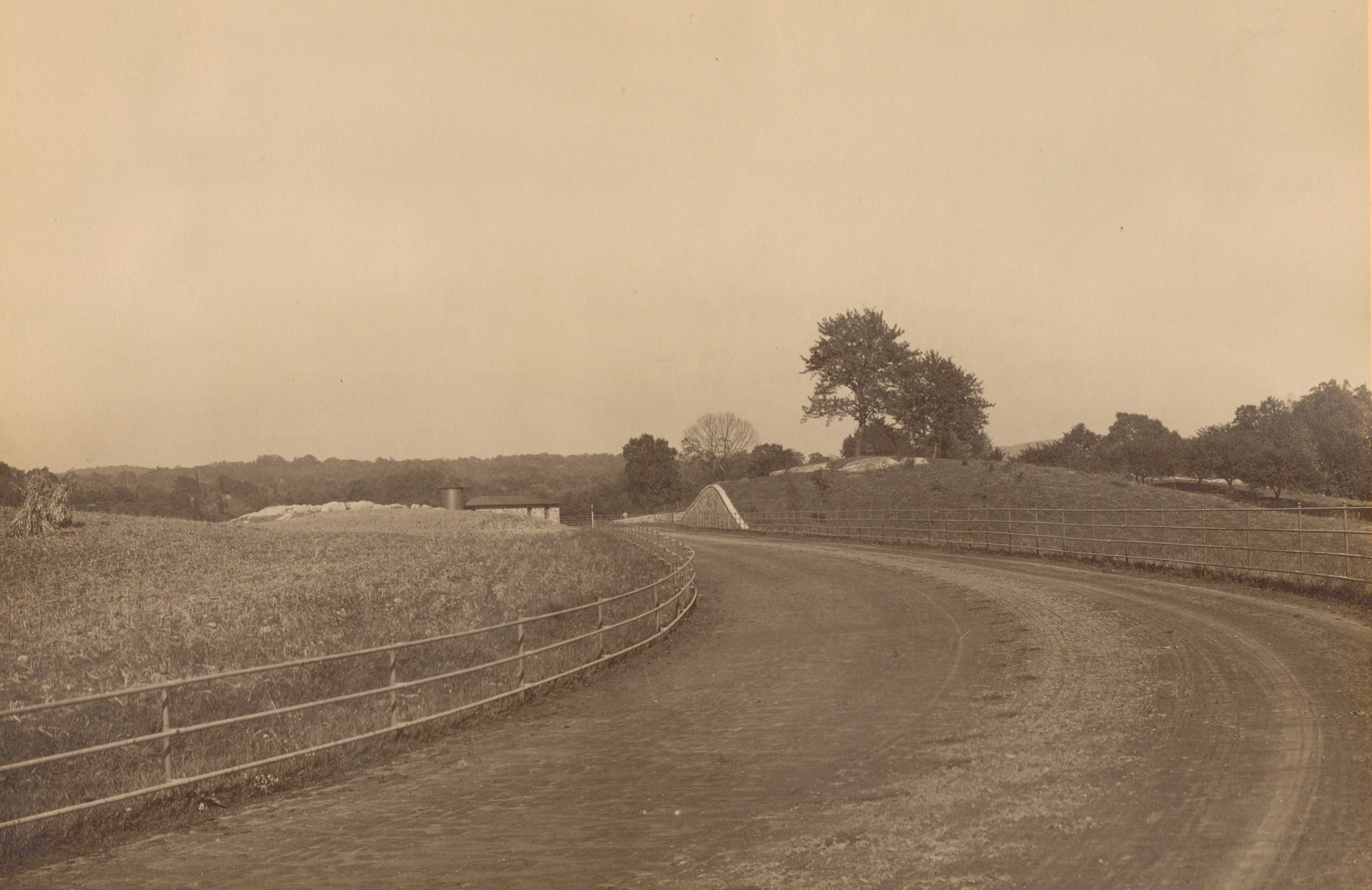
South race track1911 (attributed)The curved track, pipe fence and barn are visible in this estate-archive photograph. The matching view is attributed to E. E. Ballard's 1911 series by the field report. Source gallery ↗ · Date attribution ↗
Paths still follow an oval beside the estate’s judges’ stand and barn. The modern ruins diagram and the 2018 photographic walk identify it as Reusens’s horse-training track. A later town history also describes a racetrack in testimony from 1912; the original testimony has not yet been recovered.
Reading the outline
The highlighted line follows present-day paths mapped as the former track, checked against the estate diagram. It is not a survey of the original racing surface.
A different oval on the 1908 map
An oval north of the estate lies on Dr. E. J. Mittendorff’s property, across the brook. It is not used here as evidence for Reusens’s track.
Location. Approximate position checked against the estate diagram and present-day mapped remains. The circle is a reading area, not a measured building or property boundary.
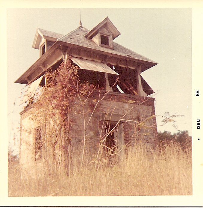
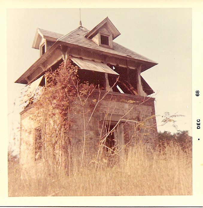
Judges’ standPrint processed December 1968The print border reads DEC 68. The damaged wooden upper storey still stands; the exposure may predate processing. Original reproduction hosted by Scenes From the Trail. Source gallery ↗
The estate diagram identifies the structure inside the oval as the judges’ stand. The 2018 photographic walk compares its surviving masonry with a 1968 view of the two-storey building.
Location. Approximate position checked against the estate diagram and present-day mapped remains. The circle is a reading area, not a measured building or property boundary.
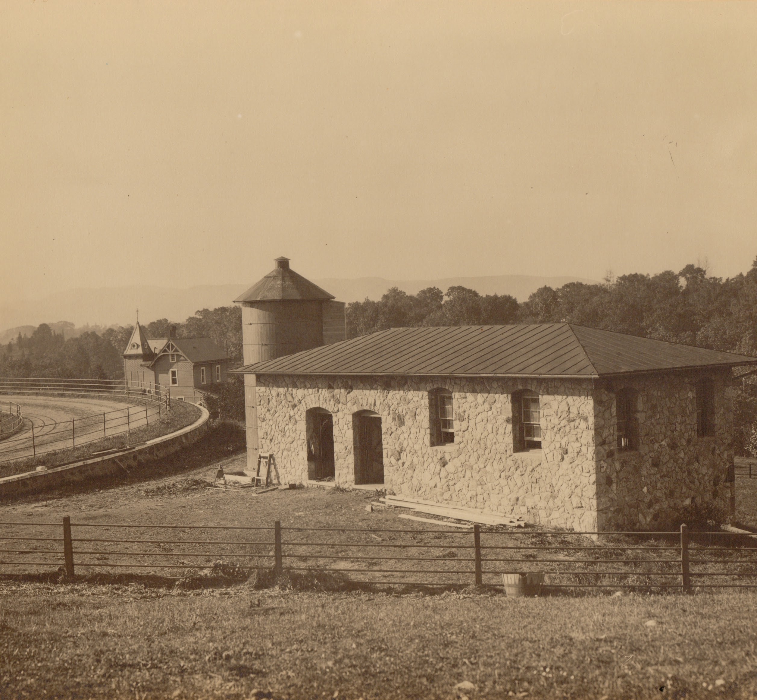
Cow stable and siloHistoric photograph · date unconfirmedThe cow stable, silo, track and Powers House appear in this estate-archive photograph. The exposure date and construction date are unconfirmed. Source gallery ↗
The stone barn stands beside the eastern end of the track. Its proximity to the oval can suggest a horse stable, but Martin McAndrews Jr. identified it as a cattle building during the 2011 estate walk.
Location. Approximate position checked against the estate diagram and present-day mapped remains. The circle is a reading area, not a measured building or property boundary.
A brick reservoir survives beside the northern leg of the track. It is one part of a larger water system whose tanks, pumps and conduits served buildings across the estate.
Supply to the lower house
The 2018 field account identifies a connection from this reservoir to the De Graaf / Powers house downhill to the east. That gives the tank a distribution role; the underground alignment remains untraced.
Location. Approximate position checked against the estate diagram and present-day mapped remains. The circle is a reading area, not a measured building or property boundary.
Fish House SpringOct–Nov 1911 (attributed)This clean estate-archive photograph matches the Fish House Spring view reproduced in the Ballard/Stevens album. The album title page, compiled in 1964, attributes the series to October-November 1911. Source gallery ↗ · Date attribution ↗
The research diagram labels this structure Fish House Spring, near the Jamawisis watercourse, also called Furnace Brook. Its name and position are documented; the suggestion that it served a carp-farming business remains a hypothesis in the town’s history.
A spring within a larger water network
The larger title map labels a two-inch tap in an eight-inch New York Central & Hudson River Railroad main, and an old reservoir. These are direct evidence of a substantial supply network in this part of the estate. The title dates on the sheet do not date the pipes.
Location. Approximate position checked against the estate diagram and present-day mapped remains. The circle is a reading area, not a measured building or property boundary.
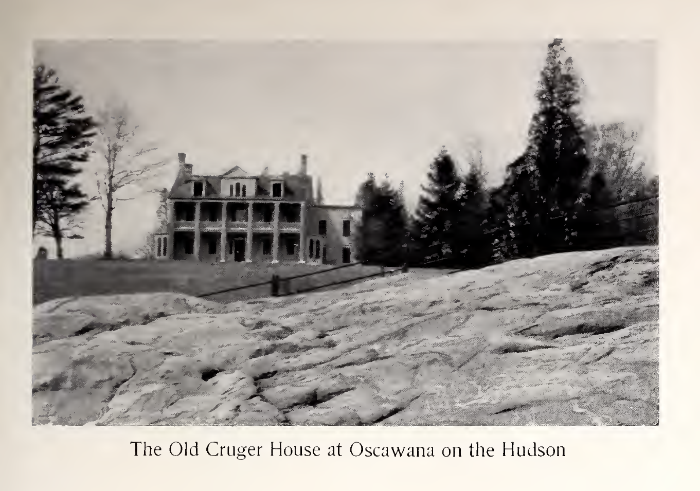
Cruger house, published 1902The columned house appears in Hamm’s Famous Families of New York. Publication dates the illustration; the exposure date is unknown. Internet Archive scan.
Historic images
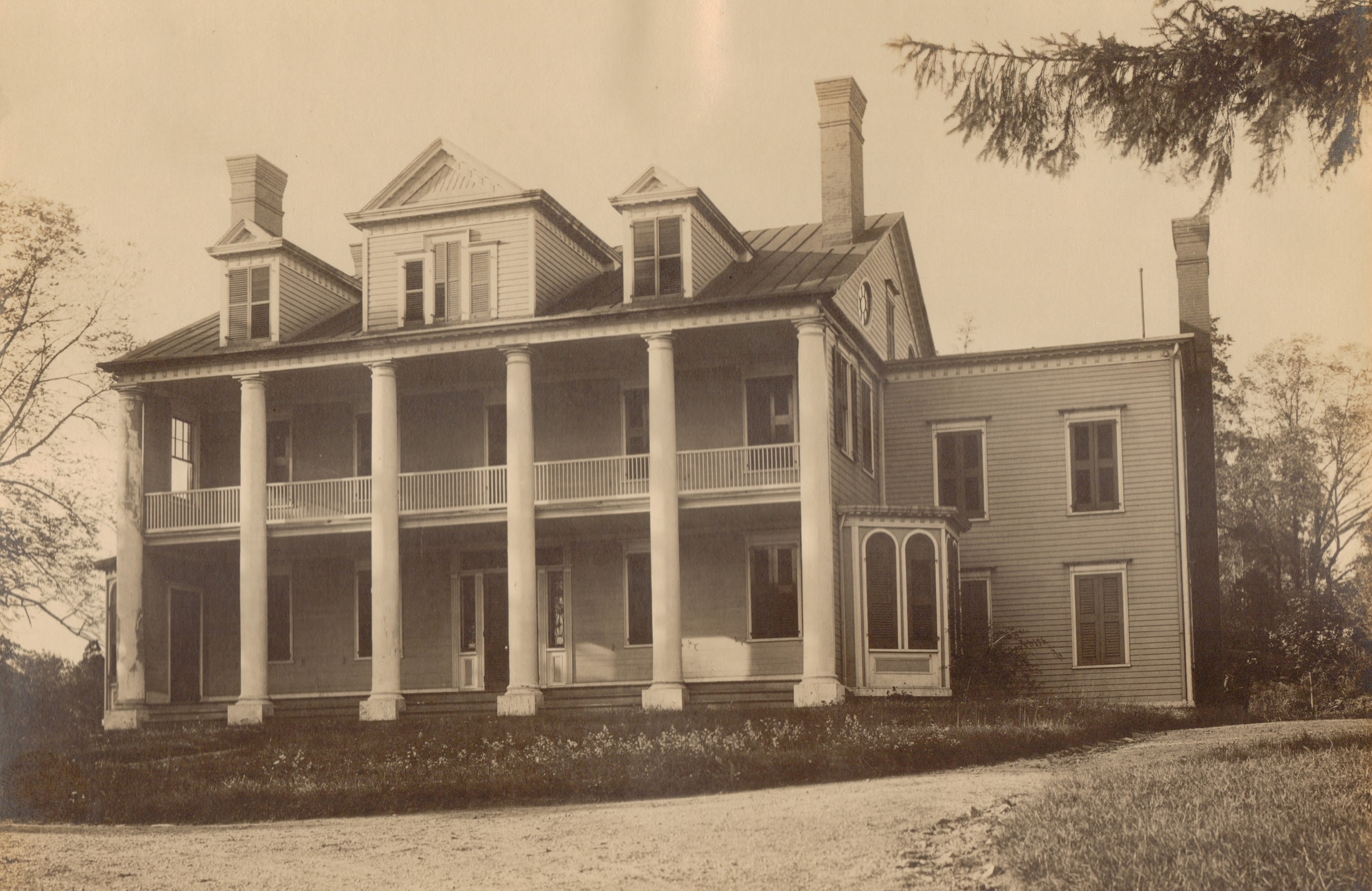
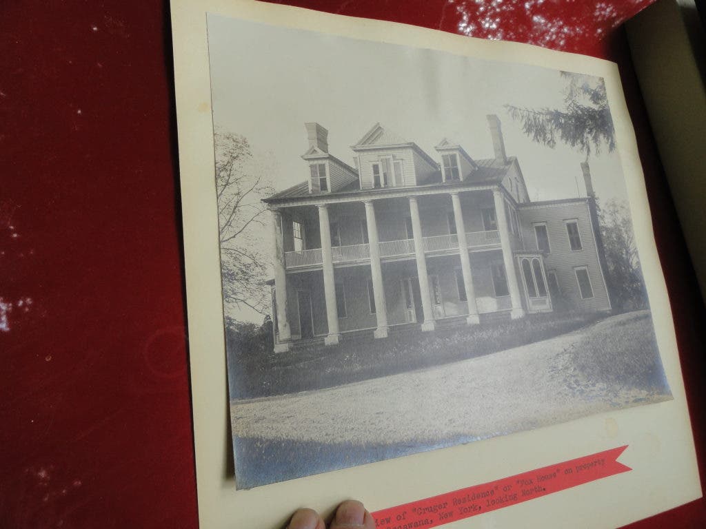
Cruger / Fox house, looking northOct–Nov 1911 (attributed)This clean estate-archive photograph matches the Cruger/Fox house view reproduced in the Ballard/Stevens album. The album title page, compiled in 1964, attributes the series to October-November 1911. Source gallery ↗ · Date attribution ↗
The estate diagram and photographic walk identify this large foundation as the Cruger or Fox house. It is separate from the later main-house site farther east. The family associations require care: a house label alone does not establish its construction date or every owner.
County history describes Nicholas Cruger’s mansion near the landing
Bolton’s 1848 county history describes Nicholas Cruger as the occupant of a mansion near Crugers landing. It separately names Benjamin Odell as occupant of the Ramsay residence and mill. This publication does not identify the surviving foundation or date the mansion’s construction.
Location. Approximate position checked against the estate diagram and present-day mapped remains. The circle is a reading area, not a measured building or property boundary.
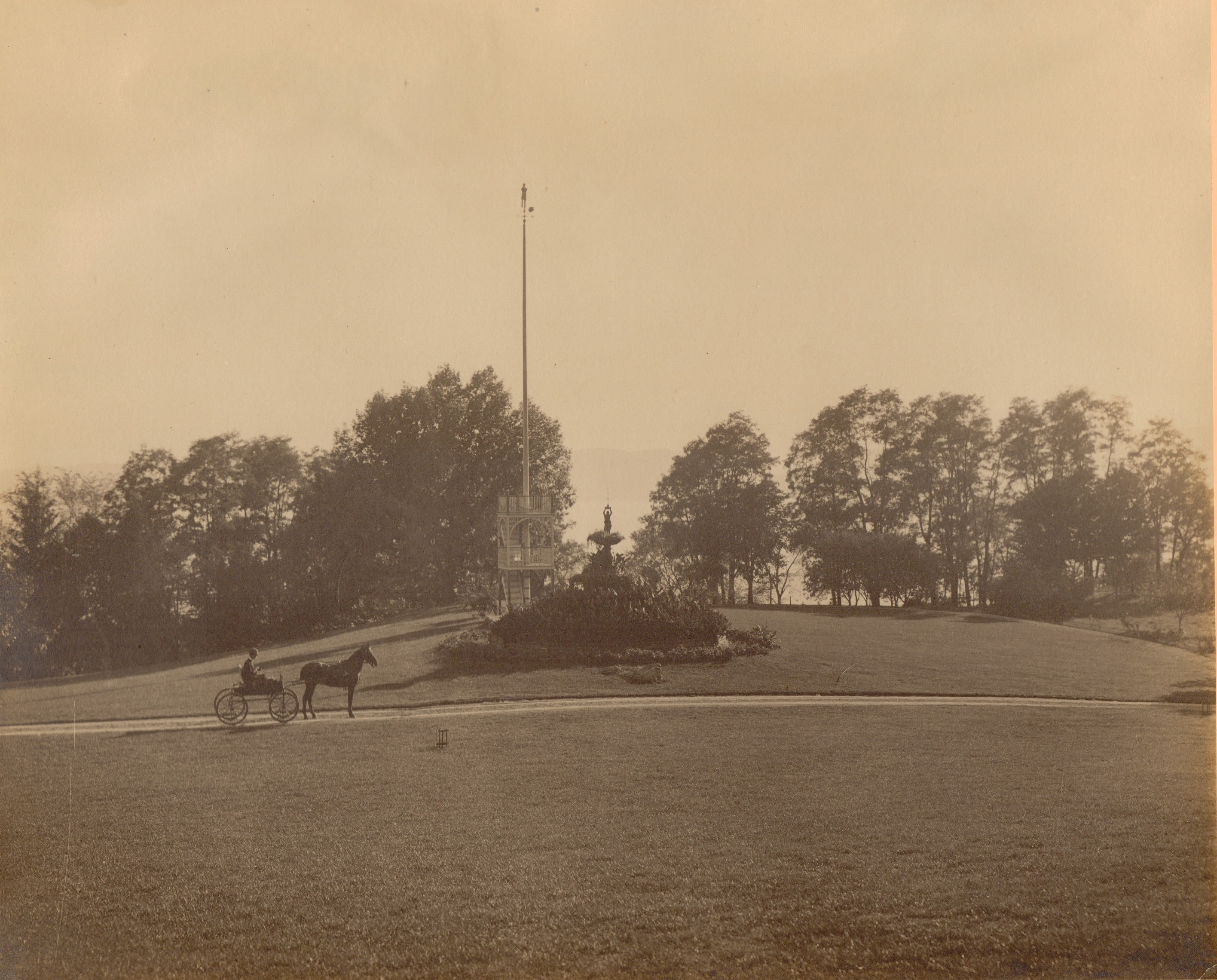
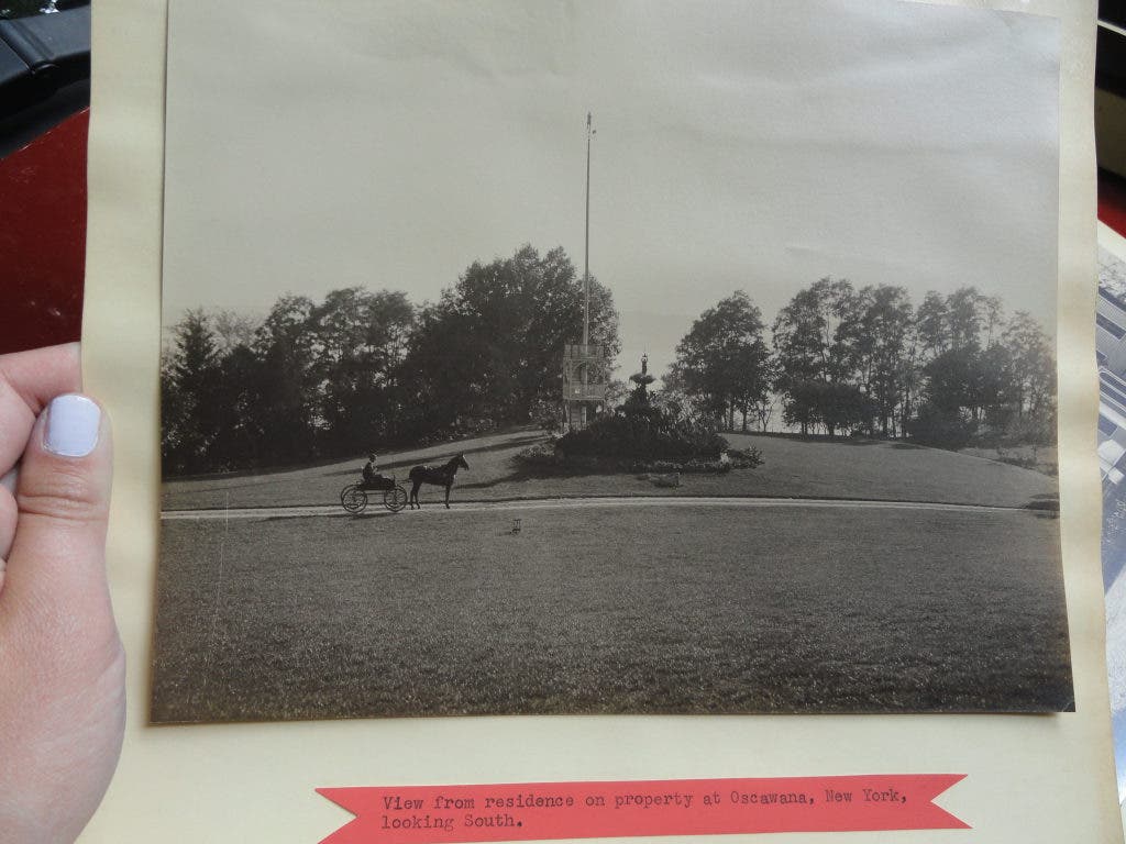
Fountain and flagpole, looking southOct–Nov 1911 (attributed)This clean estate-archive photograph matches the fountain-and-flagpole view reproduced in the Ballard/Stevens album. The album title page, compiled in 1964, attributes the series to October-November 1911. Source gallery ↗ · Date attribution ↗
The octagonal basin, brick pedestal and fallen metal tiers identify the grand fountain below the main house. Photographs from the 2011 estate walk and the 2018 field visit show matching remains. A southward view in the Ballard album shows the assembled fountain beside the flagpole.
Three fountains, separate locations
The ruins diagram marks this large lower fountain, a smaller fountain near the house, and another near the southwest gate. The 2011 correction of a supposed gazebo concerns this lower basin; the other symbols are not combined with it.
Location. Approximate position checked against the estate diagram and present-day mapped remains. The circle is a reading area, not a measured building or property boundary.
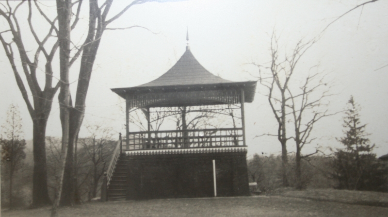
Reservoir beneath the gazeboHistoric photograph · date unconfirmedThe source identifies the lower structure as water storage for the main house and the upper level as a gazebo. Original reproduction hosted by Scenes From the Trail. Source gallery ↗
A reservoir beneath a gazebo stored water for the main house, according to the 2018 field account. The historic photograph shows how a working water structure also served as a garden building.
Location. Estimated from the estate ruins diagram using three matched landmarks. Independent comparisons differed by 14–35 metres; the 100-metre circle allows for other diagram distortion. This is a broad site estimate, not a measured footprint.
The diagram records this feature but does not give a construction date. No dated construction event is inferred.
The estate ruins diagram places a small fountain near the main house, distinct from the grand fountain farther south.
Location. Estimated from the estate ruins diagram using three matched landmarks. Independent comparisons differed by 14–35 metres; the 100-metre circle allows for other diagram distortion. This is a broad site estimate, not a measured footprint.
The diagram records this feature but does not give a construction date. No dated construction event is inferred.
The estate diagram marks a fountain at the southwest entrance. Its position helps trace water use beyond the immediate house grounds.
Location. Estimated from the estate ruins diagram using three matched landmarks. Independent comparisons differed by 14–35 metres; the 100-metre circle allows for other diagram distortion. This is a broad site estimate, not a measured footprint.
The diagram records this feature but does not give a construction date. No dated construction event is inferred.
The ruins diagram identifies a pump west of the grand fountain. Its proximity and label suggest a fountain supply function; its intake and pipe route have not been established.
Location. Estimated from the estate ruins diagram using three matched landmarks. Independent comparisons differed by 14–35 metres; the 100-metre circle allows for other diagram distortion. This is a broad site estimate, not a measured footprint.
The diagram records this feature but does not give a construction date. No dated construction event is inferred.
Pump remains near Furnace Brook are described in the 2018 field account as sending water uphill. This is a key link between the low-lying water source and the estate above it.
Location. Estimated from the estate ruins diagram using three matched landmarks. Independent comparisons differed by 14–35 metres; the 100-metre circle allows for other diagram distortion. This is a broad site estimate, not a measured footprint.
The diagram records this feature but does not give a construction date. No dated construction event is inferred.
The ruins diagram marks a pump room beside Furnace Brook, upstream from the mapped pump. It belongs in the reconstruction of the estate’s water collection and pumping works.
Location. Estimated from the estate ruins diagram using three matched landmarks. Independent comparisons differed by 14–35 metres; the 100-metre circle allows for other diagram distortion. This is a broad site estimate, not a measured footprint.
The diagram records this feature but does not give a construction date. No dated construction event is inferred.
The ruins diagram labels a controlling tank near the brook-side pump room. Its exact operating role and connections remain questions for the system reconstruction.
Location. Estimated from the estate ruins diagram using three matched landmarks. Independent comparisons differed by 14–35 metres; the 100-metre circle allows for other diagram distortion. This is a broad site estimate, not a measured footprint.
The diagram records this feature but does not give a construction date. No dated construction event is inferred.
The ruins diagram marks a broken dam on Furnace Brook. It records water control along the brook; a construction date and the relation to later pumping equipment are not yet established.
Location. Estimated from the estate ruins diagram using three matched landmarks. Independent comparisons differed by 14–35 metres; the 100-metre circle allows for other diagram distortion. This is a broad site estimate, not a measured footprint.
The diagram records this feature but does not give a construction date. No dated construction event is inferred.
The 2018 field account identifies the De Graaf / Powers house as the downhill destination of water from the track reservoir. The historic cow-stable view shows a house beyond the barn, providing landscape context for the estate’s agricultural and residential buildings.
Location. Broad estimate from the ruins diagram, aligned to three identified estate landmarks; not a measured house footprint.
The connection is described in a later field account. A construction date and complete ownership sequence have not yet been established.
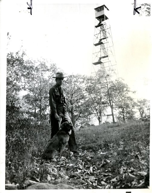
Nelson Mountain fire tower standingHistoric photograph · exposure date unknownAttributed to Westchester County Historical Society by Scenes From the Trail. The photograph is not assigned a construction-year date. Source gallery ↗
The collapsed Nelson Mountain fire tower stands in the history of forest-fire detection on Salt Hill. DEC dates its construction to the 1950s and discontinuation to the early 1970s. A 2017 photographic visit documents the fallen steelwork.
Location. Approximate reading of the DEC infrastructure map, transferred using the geographic control in its current map. The circle is a map-reading allowance, not a structure footprint or property boundary.
The management map records this feature; it does not date its construction. Generic structure symbols have not been assigned a building use without supporting evidence.
DEC’s infrastructure map identifies this feature. Structure symbol; draft text describes collapsed church on summit. Association probable, individual footprint not surveyed.
Location. Approximate reading of the DEC infrastructure map, transferred using the geographic control in its current map. The circle is a map-reading allowance, not a structure footprint or property boundary.
The management map records this feature; it does not date its construction. Generic structure symbols have not been assigned a building use without supporting evidence.
Blue Lake occupies the lower part of Salt Hill. DEC records former foundations, root cellars and a spring house on the property, while its infrastructure map shows structures and wells around the lake. The construction date of the lake’s dam is not established in the records reviewed here.
Location. Approximate reading of the DEC infrastructure map, transferred using the geographic control in its current map. The circle is a map-reading allowance, not a structure footprint or property boundary.
The management map records this feature; it does not date its construction. Generic structure symbols have not been assigned a building use without supporting evidence.
DEC’s infrastructure map marks a structure southwest of Blue Lake. Its original use has not been established.
Location. Approximate reading of the DEC infrastructure map, transferred using the geographic control in its current map. The circle is a map-reading allowance, not a structure footprint or property boundary.
The management map records this feature; it does not date its construction. Generic structure symbols have not been assigned a building use without supporting evidence.
DEC’s infrastructure map identifies a water tower south of Blue Lake. The map establishes its approximate location, but does not date its construction or identify the buildings it supplied.
Location. Approximate reading of the DEC infrastructure map, transferred using the geographic control in its current map. The circle is a map-reading allowance, not a structure footprint or property boundary.
The management map records this feature; it does not date its construction. Generic structure symbols have not been assigned a building use without supporting evidence.
DEC’s infrastructure map identifies this feature. Structure symbol near western perimeter; original function unverified.
Location. Approximate reading of the DEC infrastructure map, transferred using the geographic control in its current map. The circle is a map-reading allowance, not a structure footprint or property boundary.
The management map records this feature; it does not date its construction. Generic structure symbols have not been assigned a building use without supporting evidence.
DEC’s infrastructure map identifies this feature. Structure symbol southeast of water tower; original function unverified.
Location. Approximate reading of the DEC infrastructure map, transferred using the geographic control in its current map. The circle is a map-reading allowance, not a structure footprint or property boundary.
The management map records this feature; it does not date its construction. Generic structure symbols have not been assigned a building use without supporting evidence.
DEC’s infrastructure map identifies this feature. Well symbol; draft proposes capping/closure, completion unverified.
Location. Approximate reading of the DEC infrastructure map, transferred using the geographic control in its current map. The circle is a map-reading allowance, not a structure footprint or property boundary.
The management map records this feature; it does not date its construction. Generic structure symbols have not been assigned a building use without supporting evidence.
DEC’s infrastructure map identifies this feature. Well symbol; draft proposes capping/closure, completion unverified.
Location. Approximate reading of the DEC infrastructure map, transferred using the geographic control in its current map. The circle is a map-reading allowance, not a structure footprint or property boundary.
The management map records this feature; it does not date its construction. Generic structure symbols have not been assigned a building use without supporting evidence.
DEC’s infrastructure map identifies this feature. Small water body by Route 129, distinct from Blue Lake.
Location. Approximate reading of the DEC infrastructure map, transferred using the geographic control in its current map. The circle is a map-reading allowance, not a structure footprint or property boundary.
The management map records this feature; it does not date its construction. Generic structure symbols have not been assigned a building use without supporting evidence.
The present road leads into the former farm landscape from Old Post Road North. Its mapped route is shown for orientation; the date of naming and continuity with the original farm drives remain unverified.
Location. high current junction. The circle describes location uncertainty or broad landscape context, not a property boundary. Historical identification does not imply public access.
No construction or road-naming date has been established for this individual feature.
View from Prickly Pear Hill — published in 18661866 publication; exact drawing and visit dates unknownEngraving in Benson J. Lossing’s The Hudson, printed p. 316 / PDF p. 332. Full published page from the Library of Congress / Internet Archive scan, digitization sponsored by the Sloan Foundation. Croton Friends of History’s Croton in the 1850s supplied a research lead. This is an illustrated view of the surrounding landscape, not a photograph of Finney Farm. Its exact viewpoint and the farm’s parcel relationship are unverified. Source gallery ↗
The 1908 Hyde atlas labels this landscape “Mrs. Finney 70a.” By the 1981 village survey, the farm was also a setting for modern architecture: the survey identifies Marcel Breuer’s Neumann house alongside the older main house and barnyard buildings. The 1956 Interiors feature supplies an original architectural record; its plan has not yet been located precisely on this map.
Indigenous quarrying in the surrounding hills
A 2021 archaeological study reports three precontact quarry sites on Prickly Pear Hill, documented by BTK Associates in 1990. Quartz and chert, worked stone tools and flakes record Indigenous use of the wider uplands. The study does not establish that these sites lay within the 70-acre tract labeled Mrs. Finney in 1908. The 1990 survey itself has not been examined here; 1990 is a documentation date, not an occupation date.
Cattle quarantine and farm experiments
The village’s 1992 waterfront plan describes Finney Farm as an earlier quarantine station for imported cattle and a place to test farm implements and techniques. This retrospective account gives no operating dates, ownership sequence or construction date for the surviving concrete barn remains.
Prickly Pear Hill in an 1866 book
Benson J. Lossing describes climbing nearby Prickly Pear Hill with James Cockroft and J. W. Frost, and explains its name by the prickly pear cactus growing there. His book includes the illustrated view shown here. The 1866 date is the publication year; the passage does not date the climb. Croton Friends of History’s article supplied a lead to this original account. The view concerns the surrounding landscape, not an identified Finney Farm building or a surveyed viewpoint.
Location. moderate general location; boundary unverified. The circle describes location uncertainty or broad landscape context, not a property boundary. Historical identification does not imply public access.
The house is associated with Mabel Dodge in local historical accounts. The village’s 1981 survey describes the farm’s main house and barnyard buildings. The surrounding Southwest interiors on the mixed Yale album pages are not photographs of this Croton house.
Location. moderate historical association and approximate location. The circle describes location uncertainty or broad landscape context, not a property boundary. Historical identification does not imply public access.
No construction or road-naming date has been established for this individual feature.
Roofless barn at Finney FarmAttributed circa 1916–19 · exact exposure date unknownThe captioned Croton photograph from a mixed Yale album. Surrounding Taos photographs are separate locations. Approximate compound location; exact viewpoint unregistered. Source gallery ↗
A photograph captioned “Finney Farm–Croton” shows roofless masonry walls, circular openings and trees growing inside. The village’s 1981 survey independently records a roofless barn with a grass floor. This marker identifies the approximate agricultural compound; the photograph has not been registered to a surviving footprint.
Location. moderate compound; low exact footprint. The circle describes location uncertainty or broad landscape context, not a property boundary. Historical identification does not imply public access.
Poster for the June 1963 civil rights rallyOriginal event poster from Lorraine Hansberry’s papers, NYPL Schomburg Center. It prints June 16 and Temple Israel on Glengary Road; the archive supplies the year 1963. Advertised participants are distinguished from the newspaper’s report of the meeting.
After a January 1931 fire, Hessian Hills rebuilt with a long classroom wing designed by Howe and Lescaze. The building appeared in MoMA’s 1932 architecture exhibition; a second wing followed in late 1932. The village’s 1981 inventory identifies the former classroom wing within Temple Israel. Lee Dick’s film School (1939) preserves another view of the school’s educational life.
A school built in phases
Contemporary reporting dates the fire to January 1931 and describes parents helping with rebuilding. MoMA’s 1932 catalog illustrates the completed classroom wing and dates it 1931. TIME’s December 19, 1932 report describes a recently dedicated second wing with an auditorium, music room, showers and lockers; it does not give the dedication day.
Watch the original film
The National Film Preservation Foundation source links to School (1939), directed by Lee Dick and sponsored by the Progressive Education Association and American Film Center. Its 24-minute transfer comes from a Library of Congress 16mm print. Exact filming and first-showing dates have not been verified here.
From school to synagogue
The village’s December 1981 visual-environment report recognizes Temple Israel’s classroom wing as the former Hessian Hills School. The marker covers the historic campus locality within today’s larger complex; later additions should not all be treated as the original school.
A civil rights rally in 1963
An original poster names Temple Israel on Glengary Road as the venue for a June 16 rally supporting the Southern Freedom Movement, with Lorraine Hansberry as chair. The June 20, 1963 Patent Trader reports Jerome Smith receiving a standing ovation there on Sunday afternoon. The poster also advertises Isaac Reynolds and music by Judy Collins; it does not prove every advertised appearance occurred.
The architects’ joint credit
A September 1935 correction in Architectural Record, based on information supplied by both George Howe and William Lescaze, lists Hessian Hills School among the works assigned to their joint firm, Howe & Lescaze.
Before the 1931 classroom wing
TIME’s 1932 report traced Hessian Hills to Margaret Hatfield and Elizabeth Moos teaching in a garage after their families settled in Croton seven years earlier. It said the school had bought an old farmhouse by the start of its third year. These are stages in the school’s institutional history; the garage and farmhouse have not been located here, and the account does not date the present classroom wing.
Location. Approximate campus marker at the current Temple Israel complex, 31 Glengary Road, using the institution’s address and OpenStreetMap. The circle is a locality guide, not a surveyed school boundary or the footprint of the 1931 wing. The architectural catalog’s Glengary Road street geocode is not used.
Event dates distinguish the January 1931 fire, the 1932 exhibition and later wing dedication, the film’s 1939 production year, and the 1942 museum exhibition. Publication and screening dates do not establish construction or filming days.
Dummy Light in the earlier Grand Street streetscapeHistoric photograph · exact exposure date unknownThe signal stands on an earlier pale pedestal, with Grand Street shops and automobiles behind it. Reproduced by Croton Friends of History. The host attributes circa 1930; that date has not been independently verified. Photographer and original repository are not identified. Source gallery ↗Dummy Light, October 21, 20122012-10-21The Dummy Light on October 21, 2012, showing its signal head, signs and brick planting extension. Astrocog / Wikimedia Commons, CC BY-SA 3.0. Source gallery ↗ · License ↗Dummy Light junction in the 2018 engineering proposalPublished November 27, 2018 · exposure date unknownThe pedestal signal, brick planting extension and striped crosswalk appear in Provident Design Engineering’s November 27, 2018 proposal, PDF p.2. The exposure date and photographer are unidentified. This source photograph documents the junction as illustrated in the proposal; it does not date installation or a completed traffic change. Source gallery ↗Pedestal traffic signal
The Dummy Light is a working pedestal traffic signal in the middle of Grand Street and Old Post Road South. Former village maintenance worker Fred Sorenson recalled that it began operating about 1926. Its signal head, controller and masonry island have changed over time. The junction itself is older: nineteenth-century maps show a cistern here, and Marc Cheshire’s Croton History research connects the road fork to a 1789 survey.
What makes it a dummy light?
Carl Oechsner’s history, edited by Gretchen Bock for Croton Friends of History, defines the term as a traffic light mounted on a pedestal in the middle of an intersection. Sorenson, who serviced Croton’s light, recalled its operation beginning about 1926 and a later control box installed around 1970. These are two different equipment milestones; the box’s Marbelite label does not establish the maker or installation year of every part of the signal.
An older road fork
Christopher Colles’s 1789 road survey shows a branch marked “to Crompond” near mile 40 on the Albany Post Road. Marc Cheshire’s Croton History article identifies this fork with the present Grand Street junction by the Dummy Light. The original map documents the road connection, while the identification with today’s intersection is Cheshire’s historical interpretation; the modern identification is approximate.
From water storage to traffic island
Before the signal, a cistern was mapped at this junction. The November 1903 Sanborn sheet labels it directly; a reproduced December 1897 sheet shows an earlier record. Those map dates establish the cistern’s presence, without telling us when it was built or the full extent of its underground structure.
A landmark recognized in 1981
The village’s 1981 visual-environment report singled out the traffic stanchion at Old Post Road South and Grand Street. It described the landscaped masonry island as helping maintain the Upper Village’s human scale. This is evidence of the junction’s civic significance in 1981, rather than a date for the light’s construction.
Repairing the signal and island
A working pedestal traffic signal at Grand Street and Old Post Road South. The village documented masonry reinforcement in 2016 and repaired its brickwork after a hit-and-run by December 9, 2023. Flashing-red conversion was proposed in 2016 and remained under discussion in 2022; these records do not establish that conversion occurred.
The 2018 proposal and 2019 authorization
Provident’s November 27, 2018 proposal called for traffic and pedestrian counts, crosswalk analysis, and comparison of signalized, unsignalized and roundabout alternatives while considering the junction’s history. On March 4, 2019, trustees voted 5–0 to authorize the manager to approve Provident’s $5,900 proposal. The discussion distinguished studying traffic around the Dummy Light from deciding its future: trustees emphasized keeping the landmark, while the mayor said choices would follow the consultant’s findings. This authorization predates the fall 2019 commissioning account in the manager’s 2022 memo. Neither the proposal nor the vote establishes that an alternative was selected or built.
The 2020 all-way-stop proposal
The March 16, 2020 minutes record presentations of the traffic study at work sessions on September 23, 2019 and March 9, 2020. Their recitals refer to five concept plans for the intersections. Trustees discussed a resolution endorsing Concept Plan 4, an all-way stop at Grand Street and Old Post Road South, with $6,000 for design drawings. After discussion, Resolution 47 was tabled.
Location. Modern OSM signal node, corroborated by official street-intersection descriptions. Approximately 10–20 m map accuracy, not a surveyed foundation position.
Cistern at Grand and South Highland AvenueDetail from original November 1903 Sanborn sheet 2. The blue CISTERN symbol marks the later Dummy Light junction. Sanborn Map Company / Library of Congress; public domain. The complete sheet, which also shows the Mt. Airy cistern, remains in the photo library.Former village cistern
A reproduced December 1897 Sanborn-Perris excerpt labels a cistern at this street junction, before the traffic light. This is a separate historical water feature beneath or beside the later light base; its full underground extent is not reconstructed.
Two cisterns before the modern supply
The town’s historical account says this cistern supplied upper Grand Street and was connected to another at the foot of Mt. Airy until 1929. It describes the triangular brick extension as later protection against vehicles. This is an attributed historical account; the full underground route has not been surveyed here.
An original map labels the cistern in 1903
November 1903 Sanborn sheet 2 labels a blue circle CISTERN at Grand Street and South Highland Avenue, matching the later Dummy Light junction. The 1897 reproduction calls the branch Old Highland Turnpike; modern maps call it Old Post Road South. The 1903 sheet also maps the Mt. Airy cistern farther along Grand. It does not draw a pipe between them.
Piped water at the junction in 1924
The August 1924 Sanborn maps six-inch water lines at Grand and South Highland Avenue, the later Dummy Light junction. Its village-wide report describes a spring-well system installed in 1911, pumping to a 450,000-gallon reservoir and distributing water by gravity and direct pumping. The 1911 date is reported retrospectively on the 1924 map; no 1911 construction document was inspected. The map does not establish when the older cistern ceased operating.
Location. Same junction as modern signal; approximate historical feature center. No underground survey.
Mapped November 1903; postcard circa 1900 by later attribution
Cistern at Grand Street and Mt. Airy AvenueDetail from original November 1903 Sanborn sheet 2. The circular symbol is explicitly labeled CISTERN. Sanborn Map Company / Library of Congress; public domain. The complete sheet remains in the photo library, alongside the separately credited Croton History postcard.
Historic images
Grand Street North at Mt. Airy Avenue — cistern and former schoolCirca 1900 (Croton History attribution)Grand Street North at Mt. Airy Avenue, circa 1900 according to Croton History. The circular cistern is at right; the school building later became the Grand Street Firehouse. Existing library image. Source gallery ↗Former village cistern
The circular street structure in the existing Grand Street North at Mt. Airy Avenue postcard is identified as the Mt. Airy cistern by Croton History. The postcard also shows the building later used as the Grand Street Firehouse.
The Mt. Airy cistern appears on an original 1903 sheet
Sanborn sheet 2, dated November 1903, explicitly labels a circular CISTERN at Grand Street and Mt. Airy Avenue. Union Free School District No. 2 is mapped between this cistern and the one at South Highland Avenue. This provides independent map evidence for the feature identified by Croton History in the existing postcard. No pipe alignment or underground dimensions are established.
Grand Street's later water mains
A twelve-inch water pipe and nearby double hydrant are mapped on Grand just below Mt. Airy Avenue in August 1924. The earlier cistern symbol is omitted, but that is not a dated closure record. Sanborn's system report describes six miles of pipe and seventy double hydrants; the exact former cistern connection is not labeled.
Private spring pipes before municipal water
In September 1910, the court in Wells v. Village of Croton-on-Hudson described iron water pipes laid before 1846 from a spring beside Mount Airy Road/Grand Street to nearby houses. Nine dwellings depended on the supply during the dispute. The court ruled against the village's threatened removal of the pipes and said the rights would have to be acquired by purchase or condemnation for a municipal system. The opinion identifies the road corridor, but does not locate the spring precisely or establish that it fed this cistern.
Location. Generalized Grand Street / Mount Airy Road South junction from current OSM road node 254208489. The postcard is not metrically registered; 50 m locality envelope.
School in 1903; firehouse and court mapped by August 1924
Former school labeled as fire department and court, August 1924Native detail of August 1924 Sanborn sheet 5, labeling the building as a fire department, Columbia Hook & Ladder, Chemical Engine Co. No. 1 and a second-floor court. Sanborn Map Company / Library of Congress; public domain. The map documents use by 1924, without establishing the conversion date.
Historic images
Grand Street North at Mt. Airy Avenue — cistern and former schoolCirca 1900 (Croton History attribution)The former school appears among the trees in the Grand Street / Mt. Airy postcard reproduced by Croton History; circa 1900 is the later host’s estimate. Source gallery ↗School adapted as fire station
The fire department identifies 154 Grand Street as its oldest station and a former Croton school. The 1981 village visual survey describes the substantial red-brick firehouse. The department dates its later renovation and apparatus-bay addition to around 2002.
Fire companies and court by 1924
The August 1924 original map labels the former school footprint Fire Dept., Columbia Hook & Ladder Co., Chemical Engine Co.No.1 and Court House on the second floor. The original 1903 map had called it Union Free School District No.2. Together these maps document a change in use by 1924, without fixing its exact conversion year.
Location. Approximate center of current OSM building way 461014002; historic school core and modern addition not separately surveyed.
1927, according to the municipal historic inventory
The Village’s Comprehensive Plan dates this stone house at 35 Old Post Road North to 1927. Its masonry is linked in that municipal account to the Wyndhurst houses and the stone used for the Croton Dam. The house entered the county historic inventory in 1988.
Location. Approximate county historic-site GIS point, object 206. The circle identifies a private historic property, not a measured building footprint or public access area.
1905, according to the municipal historic inventory
The Village’s Comprehensive Plan identifies this fieldstone house as part of the former Wyndhurst estate network and dates it to 1905. The plan describes an English Cotswold design and links its building stone to the Croton Dam. It entered the county historic inventory in 1989.
Location. Approximate county historic-site GIS point, object 205. The circle identifies a private historic property, not an estate boundary or public access area.
House built about 1873–1876 · Acker home and medical office
Historic images
Underhill–Acker House with Dr. AckerCirca 1905 · National Register nomination attributionHistoric exterior photograph, reproduced as photograph 009 in the 2017 National Register nomination. The nomination identifies Dr. Acker and supplies the approximate date. Original photographer and repository are not identified in the inspected caption. Source gallery ↗
This Italianate house at 4 Hamilton Avenue became Dr. Thomas Jefferson Acker’s home and medical office in 1886. The 2017 National Register nomination infers construction between Phebe Ann Haviland Sands’s $2,000 purchase from Richard D. Tallcot in 1873 and her $5,500 sale to Charlotte A. Underhill in 1876. It concludes that the house appears to have been built for Sands. The house was listed on the National Register in 2017 for architecture and its association with Acker’s medical practice.
Two rounds of enlargement
The nomination identifies a north addition associated with Acker’s medical office and a later wraparound verandah. It compares 1897 and 1911 Sanborn details; the present verandah is dated there to 1903–1907, while a newspaper report also describes verandah work in 1899. These references need not describe the same building campaign.
Location. Approximate point converted from the nomination’s NAD83 UTM zone 18N reference, 593125E / 4562095N, shown on its parcel map. The circle is a reading area, not the property boundary or an access invitation.
Construction is an inferred interval from conveyances and architecture in the nomination, not a verified exact completion year. Historic photograph dating follows the nomination’s caption.
Hessian Hill on the 1908 Hyde atlasExisting detail reproduced by Croton History. Printed ownership and acreage are historical atlas labels, rather than today’s property boundaries. The original Rumsey sheet is linked.
Historic images
Gardiner estate buildings on Hessian HillHistoric postcard · exposure and publication dates unconfirmedThe postcard identifies A. P. Gardiner’s country home. Reproduced by Marc Cheshire / Croton History; the exact match of each pictured building to surviving walls has not been surveyed. Source gallery ↗Hudson panorama from Hessian Hills FarmHistoric postcard · exposure and publication dates unconfirmedThe printed caption names Gardiner’s summer home. Landscape view reproduced by Croton History; it is not a picture of today’s standing manor clubhouse. Source gallery ↗Estate and country-club ruins
Stone remains beside Hudson National’s fourth green mark the former Hessian Hills Country Club clubhouse. Croton History identifies the ruins with A.P. Gardiner’s hilltop home. Contemporary reports recorded his purchase of Hessian Hill farm in January 1906; the 1908 atlas labels an 80-acre Gardiner estate and draws its winding approach. An original court report dates the country-club fire to November 8, 1930.
The Gardiners at Hessian Hill
The 1915 Elite of New York directory lists Alfred P. Gardiner and his wife, Adele Troup, with a New York City address and the entry “S.R.: Hessian Hill, Croton-on-Hudson.” This contemporary listing adds to the evidence connecting the family with the estate after the 1906 purchase reports. It does not date the house’s construction or identify the present standing stone clubhouse.
Reading the fire records
Insurers alleged deliberate burning and false inventory statements. The 1933 appeal addressed mortgage insurance rights and did not decide that arson occurred. The often-repeated 1932 fire date conflicts with the original 1932 opinion’s explicit November 8, 1930 date.
An unfinished history
Accounts disagree about how much of the 1920s golf course opened for play. The surviving records establish the country-club project, but do not settle an opening date or the number of holes actually played.
The estate’s lost landmark
Historic writing associated a rock called the Devil’s Footprints with the lower hill near Albany Post Road. Its present location is unknown. The legend does not establish a fossil or an Indigenous archaeological site.
The 1906 recording index
The county’s Cortlandt grantee index records an instrument from the executors of James H. Cockroft to Alfred P. Gardiner on February 16, 1906, citing Deed Liber 1737, page 239. Contemporary newspapers spell the seller’s surname Cockcroft. This is a recording date; the deed’s execution date and parcel description have not been checked. The entry supports further title research alongside the January purchase reports, without establishing the estate’s boundaries or dating its buildings.
Location. Approximate locality between the fourth green and fifth tee, using their OpenStreetMap positions and the club’s landmark description. The 175 m circle is not a ruin footprint or historical estate boundary. Private golf property.
1911, according to club history; golf course opened 1996
Water supplied to the arboretumConnections described in The Turf Science Group’s management plan, revised January 10, 2000, pp.103–104. Solid supply is reported installed; dashed supplements are conditional. The 32-gallon-per-minute figure is the plan’s minimum at the downstream weir, not a current measurement. Diagram shows connections, not positions. Open image for a larger view; the original plan is linked below.
Historic images
Hudson National during course constructionPublished August 1995 · exposure date unknownGolf Course News identified this photograph as Hudson National. Its stone house and newly graded grounds document the course-development period. Scan: Michigan State University Libraries, Turfgrass Information Center; photographer unidentified. It does not establish the house’s 1911 date or Larkin ownership. Source gallery ↗Standing estate house and golf club
Hudson National uses a standing stone manor as its clubhouse. The club’s PGA-hosted history dates the building to 1911 and identifies it as a former Larkin family home. That attribution has not yet been checked against a deed or building record. This standing house is separate from the Hessian Hills clubhouse ruins near the fourth green. Tom Fazio’s Hudson National course opened in 1996; a further Fazio renovation debuted in 2024.
Two structures
Keep the standing manor and the hilltop ruined clubhouse distinct. The 1911 date belongs to the standing building in the club’s history; it is not a verified construction date for Gardiner’s house.
A photograph during construction
An August 1995 Golf Course News photograph, explicitly captioned Hudson National Golf Club, shows a steep-roofed stone house amid newly graded golf-course ground. The accompanying report describes the Fazio course as 80 percent complete and expects an opening the following summer. August 1995 is the publication date; the photograph’s exposure date and photographer are not supplied. This contemporary image does not establish the house’s reported 1911 construction date or Larkin ownership.
Reading the development maps
The Village archive’s Limited Activities Map is identified in an October 19, 2020 engineer memorandum as a 1999 plan last revised January 10, 2000. The same memorandum gives March 1, 1999 for a Planning Board approval, while the Village’s 2021 minutes give March 2, 1999. The original 1999 approval should resolve that one-day discrepancy; neither date is silently treated as definitive here.
Building and wetland plan comparisonsFull figure page from Ralph G. Mastromonaco’s October 19, 2020 memorandum. The engineer describes these two annotated excerpts as overlays of earlier Village approvals. They show building outlines by the clubhouse and a wetland rehabilitation area. The page is an explanatory reproduction; original approval dates and construction completion are not established by these figures.
The course’s water-management record
The Water Control Commission’s January 5, 1999 minutes describe an irrigation pond, runoff-control edges and water-quality basins, with revised plans and construction drawings still under discussion. On April 21 the commission asked for a draft resolution to be sent to the attorney and manager for review. These contemporary records document the review process; they do not establish that requested work was completed, that a bond was released, or where those features survive today.
A linked water system in the management plan
The plan revised January 10, 2000 reports an installed Arboretum supply system: two wells feed a PVC line discharging below the irrigation-pond dam. It describes a municipal-meter bleed-off hose at roughly the same outlet. Citing an agreement dated May 5, 1999, it calls for at least 32 gallons per minute at a downstream v-notched weir; municipal bleed-off or a pond siphon could supplement inadequate flow. A separate manhole and pump were designed to return dam seepage to the pond. This records the historical plan, not present operation or a surveyed pipe route.
A later account dates drainage completion
The monitoring consultant’s April 3, 2025 report places completion of the drainage systems and water-quality basins on August 31, 1999, citing January 2002 Village correspondence. A January 2022 consultant letter gives the same date. This is a retrospective completion account, not the original WCC resolution, a bond-release instrument or the course-opening date. The report also documents continuing surface-water sampling during 2024.
Sampling the Arboretum stream
In June 2003 the Planning Board discussed how municipal hose water maintaining flow into the Arboretum stream could affect samples at SW-3a. Members agreed to EMP amendments addressing sampling locations and an annual field audit, while asking the consultant and club to settle exact positions. The minutes describe reported conditions and agreed changes; they do not establish completion or locate today’s sampling points.
A proposed practice area on Finney Farm land
In September 2003 the club presented a preliminary plan to move its driving range onto newly acquired Finney Farm land. The discussion covered a 300-yard range, two proposed water-quality basins and further drainage review. These minutes document an application discussion, not approval or completed construction. The existing clubhouse point supplies property-history context; it does not locate that proposed practice area.
The practice proposal changed during review
The September 2003 preliminary plan described a 300-yard range. By November 4, Sasaki proposed a 285-yard range realigned northwest, a short-game area and a 1,500-square-foot teaching building. Two water-quality basins would manage stormwater. The proposal also called for closing and revegetating Finney Farm Lane and turning the existing range into old-field habitat. The Planning Board was still reviewing the application; these minutes do not establish completed work. The autumn practice-project visit is not identified as the planned August 14 annual monitoring audit.
A growing layer above the rock
In October 2002, superintendent Gregg Stanley told Golfdom that the fairways’ sand-topdressing program began in 1998. He described a two-inch layer already built and a four-inch goal. This is an account of course-wide work and intended further treatment, not a plan of particular fairways or proof of current practice.
Wetlands connected by a controlled outlet
The plan revised January 10, 2000 describes a valve at Wetland 17, beside hole 10, controlling surface flow toward Wetland 18 beside and west of hole 12. It prescribes keeping the valve open except for storm closure, with reopening after water in Wetland 18 subsides and without increasing downstream flooding. This documents the historical drainage connection and operating rule; it does not establish present operation.
Controlled surface flow in the 2000 planFunctional relationship documented in The Turf Science Group’s EMP, printed p.91 / PDF100. The arrow shows surface-flow direction through a controlled outlet; it is not a pipe route, a geographic alignment or a statement of present operation.
Three impoundments, several monitored streams
The same plan separately identifies dams at the irrigation pond, southeast of Prickly Pear Hill Road, and at a small pond northwest of fairway 1. The baseline report distinguishes the stream entering Brinton Brook Sanctuary from the flow feeding Kaplan’s Pond and the off-property background stream supplied by Foster Court and Upland Lane ponds. These are distinct parts of the course’s water history; individual dam and sampling locations remain unverified against current features.
Two dates in the 2021 minutes file
The opening page says April 5, 2021, while the running headers, including the Resolution 46 page and final page, say March 1. This file is used here for its retrospective account of the 1994 and 1999 approvals. Its meeting date remains qualified until a separate official record resolves the conflicting labels.
Location. Approximate clubhouse building group, compared with the engineering plan and modern OpenStreetMap recreation-building geometry (way 793002288). The 200 m circle allows for an unverified match to the historic manor; it is not a surveyed building footprint. Private club.
Construction date not established; documented before Irene repairs
Low river dam / aquifer-recharge impoundment
Black Rock Dam impounds water above Quaker Bridge. The village describes its impoundment as helping recharge the drinking-water aquifer. After Irene, the village authorized inspections in 2012 and repair engineering in December 2015. An original 2017 engineering memo places the dam about 650 feet upstream of the bridge.
Ottaviano name
USACE 2020 barrier table calls dam#4 Ottaviano’s Dam, Black Rock Park. DEC lists Ottaviano’s Dam214-4114 / NY13601 with no construction year. Its coarse inventory point is near the bridge, not on the precise OSM crest; use the engineering description for placement.
The 2015 repair program
On December 7, 2015, trustees authorized $48,500 for CHA’s work on this dam, within a $91,200 two-dam contract for design, permitting and construction support. The resolution records Irene damage and FEMA funding. These records establish authorization, rather than completed repairs.
The river’s geological setting
The 1988 USGS geological sheet maps the Croton valley’s sediments and includes sections showing sand and gravel above and below finer deposits. The optional geology layer shows this landscape context. It does not identify the construction date of this dam or resolve the upper weir’s relationship to the state’s Water Supply Dams A&B inventory.
The federal project record
FEMA identifies Black Rock Dam as Project Worksheet 9094 under Irene disaster 4020. Its first grant obligation is dated May 21, 2013 and its last obligation November 15, 2022. In the October 17, 2026 snapshot, the project is marked Project Closed Out. The record lists a $438,466 estimated project cost and $161,419.50 in federal share obligated; the cost estimate excludes administration; federal share obligated is grant funding available to the State for approved project worksheets. Construction acceptance and its date remain undocumented in this dataset. FEMA separately lists Croton Water Supply Dam, PW 9095, with an $89,075 estimated project cost and $59,774.21 federal share obligated. That record supplies no plan or coordinates establishing a match to the visible upper weir or DEC Water Supply Dams A&B. FEMA describes the dataset as raw administrative data with migration and possible-error limitations.
Two FEMA project-cost estimatesEstimated total project costs from the October 17, 2026 OpenFEMA snapshot, shown on a common zero-based scale. Federal obligations are separate figures. The Croton Water Supply Dam record is unlocated here; neither the amounts nor administrative status establish physical repair completion.
Location. OSM weir 289916475; 207 m straight-line upstream of bridge midpoint versus approximately198 m (650 ft) in original engineering memo. Strong feature identity, not a surveyed dam alignment.
Water-supply locality · exact crest construction date unverified
The village’s approved water plan, 1910Connections in the design approved August 24, 1910, from the State Water Supply Commission’s report, pp.211–212. The reservoir capacity is proposed storage. This diagram does not establish construction completion, locate pipes or identify the present river weir. Open image for a larger view; the original decision is linked below.Water-supply dam locality (provisional identity)
This upper river weir is near the village wellfield and the Water Supply Dam locality described in municipal records. The state inventory records village-owned Croton Water Supply Dams A&B with a 1960 construction year at a nearby generalized point. The precise relationship between that complex and this crest remains uncertain.
A nearby inventory record
DEC’s Water Supply Dams A&B record gives 1960 as its construction year, describes earth and rockfill, and records a 1973 inspection. Its small tributary drainage area differs from the main Croton River. These attributes have not been verified for this present crest; the mapped association remains provisional.
The 2015 repair program
On December 7, 2015, trustees allocated $42,700 to the named Water Supply Dam within a $91,200 two-dam CHA contract for design, permitting and construction support. The resolution records Irene damage and FEMA funding. It does not identify the present crest or establish completed repairs.
The river’s geological setting
The 1988 USGS geological sheet maps the Croton valley’s sediments and includes sections showing sand and gravel above and below finer deposits. The optional geology layer shows this landscape context. It does not identify the construction date of this dam or resolve the upper weir’s relationship to the state’s Water Supply Dams A&B inventory.
The village water plan approved in 1910
At a special election on June 21, 1910, voters approved a $70,000 municipal water project. The State Water Supply Commission approved its maps and profiles on August 24. The design used tubular wells in riverbank sand and gravel, a pumping station, a 12-inch pumping main and a proposed 750,000-gallon reservoir in the easterly village. Trunk lines of 12 and 10 inches would supply street mains and fire hydrants. These are the approved design and dates, not a record that construction was complete.
What the approval does and does not locate
The decision places proposed wells about 1,500 feet south of New Croton Dam and about 100 feet north of the river. Its later discussion describes the stream opposite those wells about half a mile below the dam. Those distances differ, so neither is used to plot a well here. This is context for the water-supply corridor; the decision does not identify or date the present weir. The reservoir is not located on this map.
A proposal and a later operating description
The 1910 design calls for 750,000 gallons of storage. The 1924 Sanborn report describes a system installed in 1911 with a 450,000-gallon reservoir. These documents describe different stages; they do not establish whether the same tank was reduced, replaced or built differently. The commission’s brief summary also estimates $75,000, distinct from the $70,000 election authorization in the reproduced decision.
Location. OSM physical weir geometry is specific; historic Water Supply Dam A&B identity remains probable, not proven. The 200 m circle reflects that identification gap and covers the coarse DEC point.
Records from July 1933; supplementary gauge before October 1941
Croton’s wells in the 1936 investigationOriginal printed page 206, USGS Water-Supply Paper 817, published 1937. C. E. Jacob describes the village’s three shallow supply wells and their connection. The page’s well-location table uses relative distances, not verified modern coordinates.Former USGS river-measurement site
USGS measured Croton River flow here in the 1930s. Its original 1934 report places the recorder 25 feet downstream of Quaker highway bridge and notes daily flow changes caused by pumping the village water-supply wells. A later USGS station history describes the former Quaker Bridge recorder and concrete control, used before October 1941.
The river gauge was part of a groundwater investigation
C. E. Jacob’s account of the lower Croton Valley describes a USGS investigation with the City of Ossining begun in July 1933, with three stream-gauging stations and nine observation wells. A more detailed investigation begun in July 1936 expanded the observation network to 47 wells. These were valley-wide investigations; the bridge marker does not locate all those installations.
How the village drew water in 1936
The same report describes Croton-on-Hudson’s three shallow caisson supply wells, connected by open-joint tile and pumped by suction. It reports average daily pumping below 500,000 gallons and effects on water levels in nearby wells. This is a description of the system at that time, published in 1937; it does not establish construction dates or the positions of present wells or dams.
Location. Approximate locality immediately downstream of the historic bridge, based on the original 25-foot description. The riverbank recorder and concrete control have not been individually surveyed.
1975 gift (organizer’s account) · preserve developed from 1994
Arboretum paths and wetlandUndated visitor map published by Croton Arboretum; the brochure credits Croton Lions support. It shows the boardwalk, gazebo, streams and connections toward Brinton Brook and Hixson Road. Schematic, without surveyed coordinates.
Historic images
Accessible boardwalk through the arboretum wetlandUndated photographUndated photograph published by Croton Arboretum and Sanctuary. The finished boardwalk curves through wetland vegetation. This is not a dated construction photograph or identification of the 2010 extension. Croton Arboretum and Sanctuary; photographer unidentified, no open reuse license stated. Source gallery ↗Gazebo on the arboretum boardwalkUndated photographUndated photograph published by Croton Arboretum and Sanctuary showing the gazebo and its boardwalk approach. The organizer dates the first gazebo dedication to April 1998; the photograph’s exposure date is unknown. Croton Arboretum and Sanctuary; photographer unidentified, no open reuse license stated. Source gallery ↗Tree identification on the arboretum trailUndated photographUndated photograph published by Croton Arboretum and Sanctuary showing a tree-identification sign beside a tree. Organizer Karen Jescavage-Bernard reported the Tree Trail signage in 2018; this photograph is not independently dated to that installation. Croton Arboretum and Sanctuary; photographer unidentified, no open reuse license stated. Source gallery ↗Woodland and wetland preserve
The arboretum preserves a wooded wetland beside Hudson National. Organizers trace its original 20 acres to Samuel Rubin’s 1975 conservation gift and began developing the preserve in 1994. Trails and stream crossings came first; the first boardwalk section and gazebo were dedicated in April 1998, according to organizer Karen Jescavage-Bernard. Later sections, completed through 2018, opened the wetland to visitors who could not use the rougher paths. A separate two-acre beech-covered ledge had joined the arboretum lease by April 2006.
Land before the preserve
In her 2018 history, Jescavage-Bernard describes the future preserve on a 1926 county aerial as a dark patch of trees and water surrounded by cleared farmland. She follows the return of woodland and later suburban development through subsequent aerial surveys. This is her interpretation of the landscape; the earlier farm ownership and the original Rubin conveyance have not yet been established from land records here.
Gift and expansion
Jescavage-Bernard’s 2018 account traces Samuel Rubin’s 1975 gift to the Croton-Cortlandt Conservation Association and a later transfer to the village, with restrictions for wildlife habitat and conservation education. The original conveyances and the property’s earlier title chain remain unexamined. The preserve took Jane E. Lytle’s name in 1995; the organization identifies her as one of its directors.
A family remembrance of Jane Lytle
Jane Lytle’s mother, Mary-Emily Wilkins Lytle Wells, recalled an April 1997 ceremony honoring her late daughter in a class note published in Cornell Magazine the following spring. The report identifies Jane as a member of Cornell’s class of 1977 and the arboretum’s namesake. It leaves the ceremony’s venue unspecified.
The beech-covered ledge and the wetland
An April 2006 Village newsletter describes the former Mann parcel as a roadless two-acre addition to the Arboretum lease, with a mature beech forest on a large rock ledge overlooking the main wetland. A link to the Highland Trail was then only being discussed. The organization’s later history gives 2010 for the addition and protective rezoning; those dates may describe different stages, and the original instruments have not yet been reconciled.
A boardwalk built in stages
The accessible boardwalk took two decades to build. Organizer Karen Jescavage-Bernard dates the first boardwalk section and gazebo dedication to April 1998, crediting Dr. Dan Salzberg with the accessible trail’s vision. A contemporary village notice records a 224-foot composite-lumber extension opening on October 23, 2010. Jescavage-Bernard reports that Ferguson Carpentry built three later sections as funds allowed and finished the parking-lot connection in autumn 2018. Her 2018 account also credits a native Tree Trail with labels for about 30 species, with identification help from forester George Profous and installation by Inca Brothers Landscaping and Scout Troop 28.
Water from the adjoining golf property
The January 2000 management plan describes a supply from two wells beside the access drive, with a PVC line to the stream below the irrigation-pond dam. It also describes a municipal bleed-off hose and a pond-siphon option for supplementing insufficient flow. It cites a May 5, 1999 agreement requiring at least 32 gallons per minute measured at a downstream weir. The signed agreement and current operating records have not been inspected; no pipe route or individual water feature is surveyed here.
What visitors can see
The boardwalk carries visitors through wetland vegetation to benches and a gazebo, while rougher paths continue through the woods. Tree-identification signs connect the route to native species. The organization describes a quarter-mile boardwalk; its visitor map is a schematic guide. The photographs below show finished features at unknown dates, rather than a dated record of their original construction.
Location. Broad preserve locality centered on the modern OSM polygon’s bounding box. The 230 m circle is a location guide, not a property survey. The visitor map is schematic; individual bridges, the gazebo and the 2010 boardwalk segment are not independently located.
1830s aqueduct construction · federal survey 1975 · photographs 1978
The culvert within the aqueduct embankmentHAER measured drawing, 1975, sheet 2 of 3: plan and northeast/southwest elevations. The full sheet is in the library; the original TIFF and all three federal drawings are linked by the source catalog. No geographic overlay is inferred from this engineering view.
Historic images
Indian Creek aqueduct embankment, aerial view looking north1978 · year supplied by original HAER caption sheetAerial view looking north, showing the aqueduct embankment and culvert through the trees. The marker identifies the structure, not the camera position. Jack Boucher / Historic American Engineering Record, Library of Congress. Source gallery ↗ · License ↗Indian Creek culvert, vertical view of stream and stone portal1978 · year supplied by original HAER caption sheetIndian Brook in the foreground and the stone portal beneath the aqueduct embankment. This portrait-format exposure includes more of the wall above the arch. Jack Boucher / Historic American Engineering Record, Library of Congress. Source gallery ↗ · License ↗Indian Creek culvert, broad view of portal and buttresses1978 · year supplied by original HAER caption sheetA separate landscape-format exposure showing the arch and flanking buttresses. The original caption identifies the buttressing as a later addition, without dating it. Jack Boucher / Historic American Engineering Record, Library of Congress. Source gallery ↗ · License ↗Indian Creek culvert, aerial view of portal and embankment1978 · year supplied by original HAER caption sheetAerial view showing Indian Creek Culvert, HAER NY-108-3. Jack Boucher / Historic American Engineering Record, Library of Congress. The original caption gives no compass direction; the marker identifies the structure’s broad locality, not the camera position. Source gallery ↗ · License ↗Stone stream culvert beneath the Old Croton Aqueduct
Indian Brook passes beneath the Old Croton Aqueduct here. The stone culvert allowed the stream to cross under the high embankment carrying the aqueduct. Federal drawings from 1975 record its plan, elevations and sections; Jack Boucher’s 1978 photographs show the portal, wall and buttresses. The site lies east of Quaker Bridge Road near Reservoir Road in Crotonville.
Construction dates in the federal record
The measured drawings label the culvert 1837–1839; the later HAER summary gives 1837–38 and identifies John B. Jervis as engineer. Both place it in the original aqueduct’s construction period. The two records give slightly different historical date ranges; neither supplies an exact completion day.
Reinforcement visible in the photographs
The original caption for Boucher’s broad portal view identifies the flanking buttressing as a later addition. It does not give a reinforcement date. The photographs record the structure in 1978; Daniel Clement’s 1984 transmittal date belongs to the documentation, not the exposures.
A different crossing along Quaker Bridge Road
Here the aqueduct crosses Indian Brook. Quaker Bridge, farther north, carries the road across the Croton River. The culvert’s stream passage and the aqueduct above it carried separate flows.
Location. Approximate midpoint of the modern OSM Indian Brook culvert (way 877525618), beneath aqueduct embankment path 877525620, compared with the HAER locator/aerial and Reservoir Road landmark description. The 75 m circle is a locality guide, not a surveyed footprint; photograph camera positions are not mapped.
Jurka’s private water supply, 1966Functional reading of the original well-completion and equipment forms, county records reproduced in the 2011 assessment, Part 2, PDF pp.29–30. The 380-foot depth and five-gallon-per-minute test belong to the recorded well; the 1,000-gallon figure is pressure-tank capacity. Connections are schematic, with no mapped well position or pipe alignment. Original forms are linked in the sources.
Historic images
Jurka–Gouveia house and lawn7 September 2011Tri-State Engineering, P.C.; individual photographer unidentified. The house and lawn before village acquisition, with the glass upper floor above the stone lower level. Source gallery ↗Glass, stone and the entrance facade7 September 2011Tri-State Engineering, P.C.; individual photographer unidentified. The facade records the projecting upper floor, lower stonework and garden figures. Source gallery ↗
Edward G. Schildbach designed the house for psychiatrist Dr. Edith M. Jurka. The upper floor uses extensive glazing above a stone lower level. The original building permit authorized a one-family dwelling with a professional office; the final occupancy certificate was issued in October 1969.
The architect
The 1969 certificate explicitly names Edward G. Schildbach as architect for Jurka. An earlier primary source, the August 1955 Journal of the AIA, lists him among Columbia University’s graduating architecture students awarded William Kinne Fellows Memorial Fund traveling fellowships, with a $3,500 award. The journal supplies educational context; the local certificate establishes this commission.
Permit, inspection and occupancy
A county health approval dated August 4, 1966 already records a private water supply for Jurka’s residence. Village permit 849, application 77/67, followed on December 15, 1967. A September 11, 1969 inspection letter required railings on the spiral stairs and a final survey before permanent occupancy. Certificate 759, dated October 6, replaced temporary certificate 738 of September 11. The village’s later 1967 construction label therefore differs from the documented final-occupancy milestone.
Richard Kelly’s project archive
Yale’s Richard Kelly Papers catalog lists a Dr. Edith Jurka House project in Croton-on-Hudson for 1966–67, including lighting, architectural and structural drawings in boxes 32, 337 and 404. Kelly was a lighting designer. This establishes a surviving project-file connection; the underlying drawings have not been examined here, so no particular installed lighting scheme is attributed to him.
A house organized around the view
The February 2019 committee report describes a partly embedded lower entry, exposed rock, a custom circular wooden stair, a round fireplace mass and an upper level enclosed by glass with sliding doors and a narrow surrounding deck. Its comparisons with Philip Johnson’s Glass House and Mies van der Rohe’s Farnsworth House are the committee’s architectural reading, not evidence that either architect designed this building.
Public use and adaptation
The grounds opened while regular public use of the house remained under discussion. A later committee account recalls tours at a fall 2017 welcome event. The January 2024 working group recommended Recreation offices on part of the lower level and programming upstairs. In August 2025 the Board authorized further architectural and structural design services. Sullivan’s proposal described an accessible two-story south addition; the design documents do not establish completed construction.
Water beneath the estate
The driller’s original report dates completion of Jurka’s private well to August 8, 1966, with the report signed September 14. It records 380 feet of depth, 21 feet of casing and a four-hour pumping test yielding five gallons per minute. The associated equipment form lists a submersible pump and a 1,000-gallon hydropneumatic pressure tank. These records describe a groundwater supply; they do not establish a supply from the estate pond. The sketch is not used to plot a well or pipe route.
The house’s separate sewage system
Schildbach certified construction compliance on September 3, 1969; the county endorsement is dated September 11. The form identifies a private well and a separate sewage system built by Peter A. Camilli & Sons, with a 1,125-gallon tank and 204 linear feet of 24-inch-wide disposal trench. This describes the installation recorded in 1969, not its present condition or operation.
Location. Approximate house reference point: county building 231804, compared with the 1984 plat and aerial photographs. The 35 m circle is a locality guide, not a surveyed footprint or a claim of present interior access.
Pond during the 2011 assessment9 September 2011 · visible camera stampTri-State Engineering, P.C.; individual photographer unidentified. The pond during the assessment, with its own September 9 camera stamp. Source gallery ↗
The pond and brook appear on the 1984 preliminary plat, before the village park. The 2011 assessment describes a freshwater pond, two streams through the property and an outlet entering a subsurface drainage system. Its photographs record the water feature during Gouveia ownership.
Water on the estate
The 2011 report records the pond as a landscape feature and describes the house’s private well separately. No examined record establishes that the pond supplied the residence. The subsurface outlet’s route, the pond’s construction date and subsequent alterations remain undated.
Location. Approximate pond center from county lake/pond object 2795, compared with the 1984 plat. The 45 m circle includes the immediate brook context; no buried drain alignment or dam footprint is reconstructed.
Three-bay garage during Gouveia ownership7 September 2011Tri-State Engineering, P.C.; individual photographer unidentified. Captioned 3 Bay garage in the assessment. Shown at the broad outbuilding group. Source gallery ↗Two-car garage and storage, as captioned in the 2011 survey7 September 2011Tri-State Engineering, P.C.; individual photographer unidentified. The assessment labels this photograph “Two car garage with storage area.” The date printed in the image is September 7, 2011. This is a different structure from the separately captioned three-bay garage; individual construction dates and the exact camera position are unestablished. Source gallery ↗Second well casing recorded in 20117 September 2011Tri-State Engineering, P.C.; individual photographer unidentified. The report records a second casing northwest of the two-car garage. This dated photograph documents its appearance in September 2011; it does not date installation, identify it as the 1966 supply well, or establish its present condition. Shown with the broad outbuilding locality; the casing itself is unlocated. Source gallery ↗
The estate included more than its glass house. The 1984 plat labels a frame garage. The 2011 assessment records a metal three-car garage, a shed/office, a one-car garage and a Quonset storage building. Later park committees considered possible reuse; those suggestions do not date the buildings or prove conversion.
A second casing in the 2011 survey
The assessment records a second well casing northwest of the two-car garage, separate from its account of the domestic supply. A September 7, 2011 photograph shows the casing open. This is a dated observation: the report does not establish when it was installed, its connection to the house or pond, whether it was the well drilled in 1966, or its present condition. The broad outbuilding marker does not plot the casing.
Location. Broad locality of the upper garage/shed group, compared with county building footprints and the 1984 plat. The 70 m circle is not a footprint and does not assert that every storage structure lies at its center.
Aqueduct crossing and lake outletFunctional connections described by White in 1913. Open the diagram to enlarge it. The diagram has no geographic or vertical scale and does not describe present operation.
Historic images
Camp Bradley and incinerator, July 26, 19091909-07-26 — item-title dateThe same photograph appears as plate 164 in Lazarus White’s 1913 engineering account, whose caption identifies Camp Bradley at Croton Lake and the incinerator at right. NYPL / Board of Water Supply collection; photographer unidentified. Exact feature and camera positions are unlocated. Source gallery ↗Croton Lake pressure tunnel camp overview, May 6, 19101910-05-06 — item-title dateNYPL / Board of Water Supply construction collection. Exact camera and camp positions are unlocated; shown here as project context. Photographer unidentified. Source gallery ↗Camp Bradley water filters, May 6, 19101910-05-06 — item-title dateThe same photograph appears as plate 165 in Lazarus White’s 1913 engineering account, whose caption identifies filters used to purify water from Camp Bradley. The caption describes water from the camp; it does not identify these as drinking-water filters. NYPL / Board of Water Supply collection; photographer unidentified. Exact feature and camera positions are unlocated. Source gallery ↗Croton Lake pressure tunnel interior, October 3, 19131913-10-03 — item-title dateNYPL / Board of Water Supply construction collection. Exact camera and camp positions are unlocated; shown here as project context. Photographer unidentified. Source gallery ↗Croton Lake pressure tunnel: completed lining, February 14, 1912February 14, 1912 — NYPL item titleNYPL / Board of Water Supply construction collection. Completed lining according to the item title; the camera position within the tunnel is unlocated. Photographer unidentified. Source gallery ↗Croton Lake siphon: plan and profile, 19131913 — publicationLazarus White, 1913, plate 166. The complete plan and profile show the shafts and crossing; this page is not a registered modern overlay. University of Michigan scan via Internet Archive. Source gallery ↗Aqueduct crossing
The Catskill Aqueduct crosses beneath New Croton Reservoir through a deep pressure tunnel. A separate gated outlet on the downtake side was designed to send Catskill water into Croton Lake, linking the two water-supply systems. Engineer Lazarus White’s 1913 account describes the crossing, its workers’ camp and the outlet works.
Two routes for water
White describes the pressure tunnel as fourteen feet in diameter and about 350 feet below the lake’s high water. The downtake arrangement also allowed a controlled discharge through a separate blow-off conduit into Croton Lake. The original plan and profile show the engineering arrangement; they are not a registered modern overlay.
The construction settlement
White names Camp Bradley and describes sixteen buildings with steam heating, electric lighting and water from the lake. Wash water went to a filter bed; rainwater and construction drainage passed through settling basins and sand filters. Incinerators handled organic waste. Two NYPL photographs also appear in White’s book: plate 164 identifies Camp Bradley and the incinerator at right; plate 165 identifies filters used to purify water from the camp. These matching views establish their subjects, while the camp, filters and camera positions remain unlocated.
The lake outlet
White’s account assigns the lower 150 feet of the outlet to Contract 100, awarded to Stobaugh & Co. for $41,500. He places the bulk of that work in autumn 1911, while low lake water allowed construction behind a steel-sheet cofferdam. That account does not supply an exact completion day for the whole aqueduct.
Locating the crossing
The 500 m circle marks a broad reservoir-crossing locality. DEP’s 2015 maps and independent road-junction coordinates support this placement between Chapman Road/Croton Lake Road and Croton Dam Road. It does not locate either shaft, the camps or a photograph’s camera position.
Location. Broad approximate reservoir-crossing locality. The point is a rounded midpoint from printed-scale readings anchored to modern road junctions; the 500 m circle is a locality guide, not a tunnel footprint. Neither shaft, camp nor camera position is located by this point.
The Croft in a contemporary architectural publicationTwo exterior photographs published in The Craftsman, April 1916. Complete plate, including captions and visible S. G. Mitchell credit; Getty Research Institute / Internet Archive. Publication and exposure dates are distinct.
Historic images
The Croft hall and living roomPublished April 1916Complete interior plate, with S. G. Mitchell, New York, credit. The period captions identify Vernay’s house at Ossining; antique-material claims remain attributed. Source gallery ↗Historic estate house locality
Arthur S. Vernay’s Tudor house, The Croft, stood south of Spring Valley Road. The Craftsman published two exterior and two interior photographs in April 1916 and credited the illustrated houses to Caretto and Forster. Photographs in Teatown’s 2018 master plan match its projecting gable, carved balcony and terrace. The stable across the road became the nature center.
Architects and photographs
The original April 1916 article spells the architects Caretto and Forster. Its photographs and architectural attribution are contemporary evidence. Publication establishes the house’s presence by that issue, without an exact construction or exposure date. The article’s descriptions of imported English materials and their age are not independent authentication.
The estate buildings were distinct
Teatown’s institutional history places Vernay’s house south of Spring Valley Road and Hanna’s 1917 stable and carriage house north of it. The 2018 Croft plan labels the house beside the garage/science center. The other Teatown marker represents the stable.
Reuse and removal studies
The July 2018 revised master plan includes Croft photographs and evaluates reuse, stabilization and removal. Teatown’s statement reports a June 2019 vote to proceed with demolition and describes the garage as an already renovated science center. The statement does not document when demolition was completed.
Trade journal reports sale of the Hanna estate
Record and Guide reports George Howe’s sale of the late Dan R. Hanna’s Croft estate, describing 168 acres and a lake of about 12 acres. It credits Arthur S. Vernay with developing the estate and building its residence. The buyer is unnamed; the publication date does not establish a deed or closing date. The lake is not identified with today’s 42-acre Teatown Lake.
Location. Approximate historical house location from Teatown’s labeled 2018 site plan, compared with the road, pond-side building group and OpenStreetMap geometry. The 80 m circle allows for this interpretation; it is not a surveyed footprint or a statement of current condition.
Photograph publication, attributed ownership history, plan revision and institutional decisions are different kinds of evidence. No exact house construction or demolition day is established.
The inland parcel at 41–51 Maple Street has a history of road changes, a stream and industrial use. AKRF’s 2021 documentary study places it in Francis Larkin’s estate on an 1887 map and within Hudson Concrete Block Company property in its reading of the 1935 Sanborn. These accounts concern the inland parcel, separate from the waterfront steam brickyards.
A road and stream before the industrial buildings
The 2021 study reports that Cartwright’s 1887 map placed the parcel in Francis Larkin’s estate, with Croton Lake Avenue crossing it and a stream west of the road. It also notes a rock-cutting label at the northern end. The 1887 original is a cited source rather than a separately inspected map here; county filed Map 882 is the next original record to examine.
Subdivision is not evidence of completed houses
The reproduced 1930 Hopkins atlas shows A. E. Ottaviano’s subdivision lines and the old Maple/Croton Lake Avenue alignment, with the project parcel outlined by the 2021 study. Drawn lots do not establish that houses were built. The source is a historical map reproduction with a later project overlay.
Concrete works and later storage
AKRF’s review of the 1935 Sanborn describes a wood-frame and metal building with electrical and steam lines and a curing room. Its review of the 1950 map identifies contractor’s storage. The study also cites a 1941 office-building permit, but the original permit and these Sanborn sheets have not been separately examined here. This evidence does not establish when every building was constructed or whether a particular later building was the same structure.
Location. Approximate project-site coordinates printed in the 2021 study, Figure 1, converted from 73°53′10″W, 41°12′11″N. Figure 2 identifies parcel 78.12-3-3 west of Maple Street and north of Municipal Place. The 80 m circle is a locality guide, not a surveyed boundary or a factory-building footprint.
The 1887 and 1935 records follow the 2021 study’s retrospective map readings; the 1930 atlas is reproduced in that study and was visually checked. Map publication, proposed subdivision, construction and later use are separate milestones. The marker does not establish the parcel’s complete ownership chain or present condition.
The county bought the park in 1923. The original unlined landfill operated from 1927 to 1986. Recreation and disposal overlapped on different parts of the peninsula.
Buildings, owners, the brook and the riverfront before later fill. Available as an aligned layer on the atlas.
J. B. Beers & Co. · Scan shared by Marc Cheshire. Source record ↗
1922 · Bolton’s Indian paths
The regional Map I catalogue describes paths drawn over a contemporary street map. The Croton connection in this atlas comes from the book’s text on pp. 91–92, not a tracing of that sheet.
Source: Merwin (2010), Table 6, printed p. 94 / PDF p. 107. Read the table ↗
Names are not borders
Navish, Senasqua and Meahagh enter this atlas through later printed deed transcriptions. Sachus is a reported village; Fort Kitchawanc also has archaeological plans. These records support different claims.
Native New York continues
The Smithsonian’s Native Knowledge 360° materials include Native people’s accounts of life today, alongside regional history and the role of waterways.
Plate 231 maps villages, camps, earthworks, middens and other reported remains. The regional layer keeps the original red symbols and numbers; the accompanying pages explain the records. The brown numbered markers are separate atlas entries.
Number 10 now has a broad Croton Lake–Deer Pond reading area, supported by a later aqueduct archaeology assessment. Number 11 records a Kitchawan farm locality investigated only superficially; the farm identity remains unresolved. Both original symbols remain visible in the layer, without reconstructed village or farm boundaries.
Parker described the inventory as preliminary. His Seneca ancestry is documented in the State Library biography ↗; this map is not presented as Lenape tribal endorsement.
The base historical layers are the USGS Tarrytown quadrangle, 1892 and 1937, both cataloged at 1:62,500. They use native-resolution tiles from the official USGS GeoPDF scans, georeferenced with the GeoPDF’s own registration and the NADCON datum shift; the previous Esri-served images remain linked below. Old surveying, later shoreline change and image registration can produce visible offsets against modern streets. The overlay is a historical comparison, not a property survey.
The additional layers are independently registered historical sheets. The 1872 Beers and 1924 Sanborn details use road and building controls with separate landmark checks around 18–23 metres. The northern part of Parker’s county map has much larger offsets: a separate Ossining check differs by about 520 metres. Fit residuals are not guarantees of accuracy elsewhere. Their source and alignment notes are attached to each layer.
Place circles are editorial locality guides. Their radii indicate the broad area being discussed; they are not measured archaeological extents or statistical confidence intervals. Native entries distinguish excavated sites, reported villages, recorded landscape names and a later trail reconstruction. The Native layer extends to Ossining and Peekskill, beyond the northern coverage of the historical USGS raster. No territorial boundaries are inferred.
The museum’s Figure 5.1 adds a modern fort outline to an 1782 French map; the outline itself is not evidence drawn in 1782. Figure 5.2 compares an 1899 plan with observations in 2002. The original figures are linked rather than reprojected as precise site boundaries.
Map controls change the background survey, not the dates of the annotations. The dated-event list includes later excavations and preservation decisions; it is not a timeline of first Native occupation.
Experimental project: croton.news uses AI to generate articles from public records. Content may contain errors. Please report any inaccuracies and check our corrections log.AI-assisted experimental site — may contain errors. Corrections